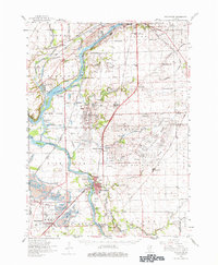
1954 Map of Wilmington
USGS Topo · Published 1979About this map
The Joliet Arsenal dominates the center of this mid-century landscape, a massive military installation bounded by extensive rail lines including the Wabash RR. To the west, the Des Plaines River and Kankakee River converge, framed by the industrial legacy of the Michigan and Illinois Canal and the Des Plaines Wildlife Conservation Area. This era marks a peak in the region's extraction economy, evidenced by the extensive Strip Mines and mine dumps surrounding Braidwood and Diamond. Local life is anchored in several small school districts and cemeteries, such as the Chicago Road Cem and the Wilmington High Sch. Significant river engineering is visible through features like the Kankakee Cutoff and various levees, while the Soldiers Widows Home in Wilmington reflects the community's established civic character.
Find a feature on this map
97 named features on this map. Tap any name to fly to it.
Don’t see what you’re looking for? This feature index may not catch every label — zoom into the map to look around manually.
Map Details
Editions of this 1954 Wilmington Map
3 editions found
Other maps of this area

1890 · Des Plaines
USGS Topo · 1:62,500

1892 · Morris
USGS Topo · 1:62,500

1892 · Joliet
USGS Topo · 1:62,500

1892 · Wilmington
USGS Topo · 1:62,500

1894 · Des Plaines
USGS Topo · 1:62,500

1900 · Des Plaines
USGS Topo · 1:62,500

1901 · Des Plaines
USGS Topo · 1:62,500

1918 · Wilmington
USGS Topo · 1:62,500

1918 · Morris
USGS Topo · 1:62,500

1922 · Kankakee
USGS Topo · 1:62,500