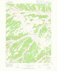
1952 Map of Wolf Ridge
USGS Topo · Published 1966About this map
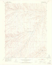
Wolf Ridge dominates the central landscape of this Rio Blanco County terrain, surveyed via aerial photography in the late 1940s. The map reveals a land defined by its drainage systems and water infrastructure, essential for ranching in this environment. A complex network of water features includes a Ditch, several instances of a Flume, and a Windmill located near the 84 Ranch. These man-made improvements highlight the effort to manage seasonal runoff through canyons like Trail Canyon and gulches such as Corral Gulch. To the southeast, the presence of the Ryan School (ABAND) near Ryan Gulch suggests a shift in the local population or educational centers by the early 1950s. The topography is meticulously detailed, showing the interplay between significant elevations like VABM Bell 6525 and the meandering paths of Duck Creek and Yellow Creek.
Find a feature on this map
21 named features on this map. Tap any name to fly to it.
Don’t see what you’re looking for? This feature index may not catch every label — zoom into the map to look around manually.
Map Details
Editions of this 1952 Wolf Ridge Map
7 editions found
Other maps of this area

1907 · Rangely
USGS Topo · 1:125,000

1907 · White River
USGS Topo · 1:125,000

1910 · White River
USGS Topo · 1:125,000

1910 · Rangely
USGS Topo · 1:125,000

1952 · Wolf Ridge
USGS Topo · 1:24,000

1952 · Yankee Gulch
USGS Topo · 1:24,000

1952 · Rock School
USGS Topo · 1:24,000

1952 · Square S Ranch
USGS Topo · 1:24,000

1954 · Vernal
USGS Topo · 1:250,000

1956 · Grand Junction
USGS Topo · 1:250,000