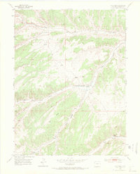
1952 Map of Wolf Ridge
USGS Topo · Published 1971About this map
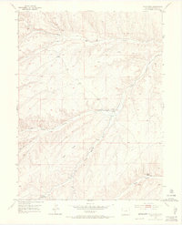
Wolf Ridge dominates this high-altitude landscape in Rio Blanco County, reflecting the sparse, utilitarian settlement patterns of Northwest Colorado in the early 1950s. The terrain is defined by a series of dramatic drainages including Yellow Creek, Corral Gulch, and Ryan Gulch, where water management was clearly a priority for the few residents. Infrastructure like the 84 Ranch and the Ryan School (Site) are connected by a network of Trails and unimproved roads, while labels for a Flume, Ditch, and Windmill highlight the engineering required to sustain ranching in this arid environment. The map captures an era of seasonal habitation and livestock grazing, marked by remote landmarks such as the VABM Bell geodetic station and various artesian wells and springs that served as critical anchors for the local ranching economy.
Find a feature on this map
20 named features on this map. Tap any name to fly to it.
Don’t see what you’re looking for? This feature index may not catch every label — zoom into the map to look around manually.
Map Details
Editions of this 1952 Wolf Ridge Map
7 editions found
Other maps of this area

1907 · Rangely
USGS Topo · 1:125,000

1907 · White River
USGS Topo · 1:125,000

1910 · White River
USGS Topo · 1:125,000

1910 · Rangely
USGS Topo · 1:125,000

1952 · Wolf Ridge
USGS Topo · 1:24,000

1952 · Yankee Gulch
USGS Topo · 1:24,000

1952 · Rock School
USGS Topo · 1:24,000

1952 · Square S Ranch
USGS Topo · 1:24,000

1954 · Vernal
USGS Topo · 1:250,000

1956 · Grand Junction
USGS Topo · 1:250,000