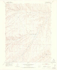
1952 Map of Wolf Ridge
USGS Topo · Published 1971About this map
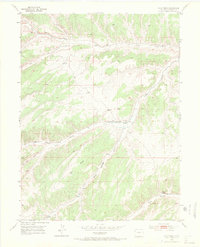
Wolf Ridge dominates this Rio Blanco County landscape, serving as a high divide between a complex network of dry gulches and seasonal watercourses. The 1952 field check documents a sparse high-desert ranching economy, centered on the 84 Ranch and several strategic water sources including an Artesian Well and Stake Springs. The presence of the Ryan School (Aband) near the confluence of Ryan Gulch and Yellow Creek suggests a previous era of more concentrated settlement that had already begun to recede by the mid-20th century. Terrain features like Corral Gulch and Box Elder Gulch define the rugged drainage patterns, while scattered Windmill sites and a Ditch indicate the persistent efforts to manage water in this arid environment. This survey provides a precise record of these isolated homesteads and geographical landmarks before modern energy development altered the region.
Find a feature on this map
20 named features on this map. Tap any name to fly to it.
Don’t see what you’re looking for? This feature index may not catch every label — zoom into the map to look around manually.
Map Details
Editions of this 1952 Wolf Ridge Map
7 editions found
Other maps of this area

1907 · Rangely
USGS Topo · 1:125,000

1907 · White River
USGS Topo · 1:125,000

1910 · White River
USGS Topo · 1:125,000

1910 · Rangely
USGS Topo · 1:125,000

1952 · Wolf Ridge
USGS Topo · 1:24,000

1952 · Yankee Gulch
USGS Topo · 1:24,000

1952 · Rock School
USGS Topo · 1:24,000

1952 · Square S Ranch
USGS Topo · 1:24,000

1954 · Vernal
USGS Topo · 1:250,000

1956 · Grand Junction
USGS Topo · 1:250,000