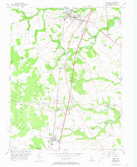
1956 Map of Wyoming
USGS Topo · Published 1973About this map
Wyoming and Camden anchor the northern reaches of this central Delaware landscape, where the Pennsylvania railroad line serves as a central spine through the agricultural heartland of Kent County. The map reveals a transition from these established village centers to a more dispersed rural economy defined by water-powered industry and community nodes. Family and community heritage is visible in landmarks like Voshell Mill on Tidbury Creek and Lexington Mill near McGinnis Pond, alongside numerous local meeting places such as St Johns Ch and the Odd Fellows Cem.
Find a feature on this map
54 named features on this map. Tap any name to fly to it.
Don’t see what you’re looking for? This feature index may not catch every label — zoom into the map to look around manually.
Map Details
Editions of this 1956 Wyoming Map
3 editions found
Other maps of this area

1899 · Vineland
USGS Topo · 1:125,000

1899 · Dover
USGS Topo · 1:125,000

1906 · Dover
USGS Topo · 1:125,000

1918 · Cedar Creek
USGS Topo · 1:62,500

1918 · Harrington
USGS Topo · 1:62,500

1919 · Cedar Creek
USGS Topo · 1:62,500

1919 · Vineland
USGS Topo · 1:125,000

1920 · Dover
USGS Topo · 1:125,000

1926 · Wyoming
USGS Topo · 1:48,000

1930 · Wyoming
USGS Topo · 1:62,500