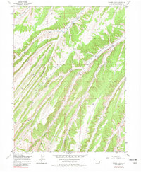
1952 Map of Yankee Gulch
USGS Topo · Published 1981About this map
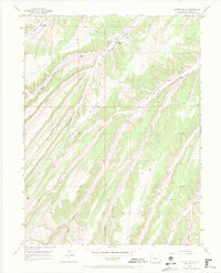
The Wagonroad Ridge divides this high-altitude landscape of Rio Blanco County, where steep drainages and isolated ranching outposts defined life in the mid-20th century. This 1952 field survey captures the area during a period of transition, noting the presence of a Shale Test Well—a concrete indicator of the geological exploration that would eventually transform the region's energy economy. Settlement is sparse, represented by family-named landmarks such as Reigle Ranch and Duckett Ranch, which were established along the reliable water sources of Ryan Gulch and Black Sulphur Creek. The intricate network of seasonal drainages, including Wet Swizer Gulch and Eureka Gulch, illustrates the complex topography that dictated movement and land use. For historians and researchers, these labels provide a precise record of early 1950s resource management and livestock operations before modern development altered the character of the gulches.
Find a feature on this map
17 named features on this map. Tap any name to fly to it.
Don’t see what you’re looking for? This feature index may not catch every label — zoom into the map to look around manually.
Map Details
Editions of this 1952 Yankee Gulch Map
6 editions found
Other maps of this area

1929 · Highmore
USGS Topo · 1:62,500

1952 · Wolf Ridge
USGS Topo · 1:24,000

1952 · Yankee Gulch
USGS Topo · 1:24,000

1952 · Rock School
USGS Topo · 1:24,000

1952 · Square S Ranch
USGS Topo · 1:24,000

1956 · Grand Junction
USGS Topo · 1:250,000

1959 · Grand Junction
USGS Topo · 1:250,000

1960 · Grand Junction
USGS Topo · 1:250,000

1962 · Grand Junction
USGS Topo · 1:250,000

1964 · Grand Junction
USGS Topo · 1:250,000