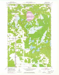
1951 Map of Zim
USGS Topo · Published 1978About this map
The St Louis River meanders through this landscape of the Mesabi Range region, defining the northern geography near Forbes. This area, heavily influenced by the iron mining industry, features a massive Tailings Pond at its center, signaling the industrial transformation of the terrain during the mid-20th century. The settlement of Zim serves as a local hub along the Duluth Missabe and Iron Range railroad, which parallels the river and connects the mining sites to southern ports.
Find a feature on this map
28 named features on this map. Tap any name to fly to it.
Don’t see what you’re looking for? This feature index may not catch every label — zoom into the map to look around manually.
Map Details
Editions of this 1951 Zim Map
5 editions found
Other maps of this area

1951 · Gilbert
USGS Topo · 1:24,000

1951 · Eveleth
USGS Topo · 1:24,000

1951 · Kirk
USGS Topo · 1:24,000

1951 · Central Lakes
USGS Topo · 1:24,000

1951 · Zim
USGS Topo · 1:24,000

1951 · Casco
USGS Topo · 1:24,000

1954 · Hibbing
USGS Topo · 1:250,000

1956 · Cotton
USGS Topo · 1:24,000

1957 · Hibbing
USGS Topo · 1:250,000

1958 · Hibbing
USGS Topo · 1:250,000