1970s Maps of La Paz County, Arizona
Explore 11 historic maps of La Paz County from the 1970s. These maps offer a rare glimpse into what life looked like during the 1970s — showing old roads, neighborhoods, homes, and landmarks that have changed or disappeared over time.
Whether you're researching your family's past, planning a metal detecting trip, or studying how La Paz County's landscape evolved across the 1970s, these high-resolution maps are a powerful tool for exploring the history of this region.
- Focus on a specific era: All maps on this page are from the 1970s, giving you a focused view of this time period.
- See what’s changed: Compare century-old streets, trails, and buildings to today's modern landscape using overlays and satellite layers.
- Research with precision: Use these maps for genealogy, historical research, land use analysis, or educational projects.
- View, download, or print: Maps are fully viewable online in high resolution, and can be downloaded or printed for your own records.
Start exploring La Paz County's history through authentic maps from the 1970s. This is your window into the past.
La Paz County, AZ maps
(11)- 1970 Map of Parker, 1973 Print
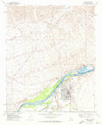 1970 Parker1973 Print · USGSThe Colorado River borderlands in the early 1970s reveal the growth of Parker alongside massive water infrastructure like the Headgate Rock Dam. Genealogists and historians can trace the Wyatt Earp House and the Indian Agency Headquarters.3 unique versions available
 - 1970 Map of Parker SE, 1973 Print
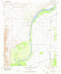
 1970 Parker SE1973 Print · USGSThe Colorado River Indian Reservation in the early seventies shows a landscape defined by industrial-scale irrigation and desert transit. Genealogists and historians can trace local landmarks like the Cremation Ground (Cem) or the path of the Atchison Topeka and Santa Fe railroad.2 unique versions available
 - 1970 Map of Parker SW, 1973 Print
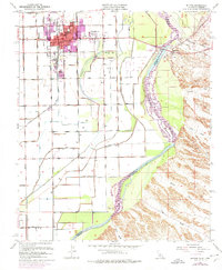
 1970 Parker SW1973 Print · USGSThe Colorado River borderlands in the early seventies reveal an intensive irrigation network carved into the desert floor. Researchers can trace the water infrastructure of the Main Canal alongside local landmarks like the Colorado River Day School and Lost Lake Resort.3 unique versions available
 - 1970 Map of Blythe, 1975 Print
 1970 Blythe1975 Print · USGSThe Colorado River valley transitioned into a modern agricultural and transit hub during the early seventies. Genealogists and local historians can trace the growth of Blythe and Ehrenberg near the Ehrenberg Cemetery and the vital Palo Verde Intake.
 - 1971 Map of Phoenix
 1971 Phoenix1971 Print · USGSCentral Arizona at the start of the seventies shows a desert metropolis expanding toward the Sun Valley retirement boom. Trace the growth of Sun City and Glendale, or locate remote historic sites like the Vulture Gold Mine and Nottbusch Cemetery.
 - 1971 Map of Dome Rock Mts SW, 1973 Print
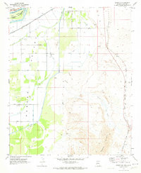
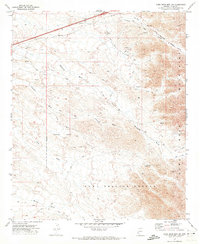 1971 Dome Rock Mts SW1973 Print · USGSArizona's western desert frontier comes into focus during the early 1970s, as mining and military activity overlap in the high desert. Mineral hunters and historians can trace the locations of the Copper Giant Mine, the Copper Chief Mine, and the sprawling Yuma Proving Ground.2 unique versions available
 - 1971 Map of Moon Mtn SE, 1973 Print
 1971 Moon Mtn SE1973 Print · USGSThe Colorado River Indian Reservation border and the high desert of La Paz County were meticulously mapped in the early seventies. Trace the tracks of miners and surveyors through the Dome Rock Mountains to find the Valenzuella Mine and Kaiser Waterhole.2 unique versions available
 - 1971 Map of Moon Mtn NE, 1973 Print
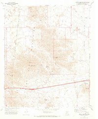
 1971 Moon Mtn NE1973 Print · USGSIn the early 1970s, this desert landscape in western Arizona was defined by its industrial activity and complex land boundaries. Trace the Colorado River Indian Reservation Boundary or locate historical extraction sites like the Gravel Pits and Gravel Pit.
 - 1971 Map of Middle Camp Mtn., 1973 Print
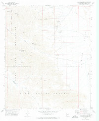
 1971 Middle Camp Mtn.1973 Print · USGSWestern Arizona prospecting was still etched into the desert floor during the early seventies. Genealogists and historians can trace old mining claims like the Darling Mine and Marquitta Mine or locate the Dome Rock Interchange along the modern highway.4 unique versions available
 - 1971 Map of Cunningham Mtn, 1974 Print
 1971 Cunningham Mtn1974 Print · USGSArizona's high desert mining country is captured here in the early 1970s, as operations dotted the foothills of the Dome Rock Mountains. Researchers can trace the trails and prospects surrounding the Copper Bottom Mine, Kellogg Mine, and Petroglyphs near Tule Springs.2 unique versions available
 - 1979 Map of Alamo Lake, 1997 Print
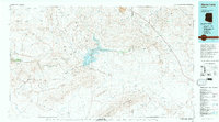 1979 Alamo Lake1997 Print · USGSThe Arizona desert at the end of the seventies reveals a landscape of massive water projects and deep-rooted mining history. Genealogists and historians can trace numerous remote claims like the Black Diamond and Nellie-Meda Mine or explore the early footprint of Alamo Lake State Park.2 unique versions available
End of results
Showing maps 1-11 of 11
Top cities of La Paz County
- Quartzsite historical maps
- Parker historical maps
- Salome historical maps
- Ehrenberg historical maps
- Bouse historical maps
- Bluewater historical maps
See more
Frequently asked questions
- What are the different types of historical maps available for La Paz County?
- What is the oldest map of La Paz County?
- Where can I purchase historical maps of La Paz County for my home or office?
- Where can I download high-res historical maps of La Paz County?
- Are there historical topographic maps available for La Paz County?
- Is there historical aerial imagery available for La Paz County?
- Where are historical maps of La Paz County sourced from?