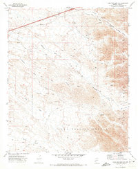
1971 Map of Dome Rock Mts SW
USGS Topo · Published 1973About this map
The Dome Rock Mountains dominate this 1970s landscape, defined by a complex network of desert drainages and mid-century resource extraction. At the base of the peaks, the Copper Giant Mine and Copper Chief Mine illustrate the region's mineral history, while numerous unnamed Prospects and Mines dot the arid slopes. The terrain is deeply incised by several major washes, including Ehrenberg Wash, Limekiln Wash, and La Paz Arroyo, which flow toward the Colorado River valley located just beyond the western margin. Significant administrative divisions shape the land use here, specifically the northern reach of the Yuma Proving Ground and the historical Old Indian Reservation Boundary. Evidence of modern infrastructure appears via the Pipeline corridors and the presence of a Rest Area in the northern corridor, providing a glimpse into the industrial and military utility of this desert expanse during the early 1970s.
Find a feature on this map
28 named features on this map. Tap any name to fly to it.
Don’t see what you’re looking for? This feature index may not catch every label — zoom into the map to look around manually.
Map Details
Editions of this 1971 Dome Rock Mts SW Map
2 editions found
Other maps of this area

1933 · Cunningham Mtn
USGS Topo · 1:48,000

1934 · Trigo Peaks
USGS Topo · 1:48,000

1939 · Trigo Peaks
USGS Topo · 1:62,500

1940 · Dome Rock Mts
USGS Topo · 1:62,500

1942 · Blythe
USGS Topo · 1:250,000

1945 · Cibola
USGS Topo · 1:62,500

1951 · Blythe
USGS Topo · 1:24,000

1951 · Blythe NE
USGS Topo · 1:24,000

1951 · Cibola
USGS Topo · 1:62,500

1952 · Mule Wash
USGS Topo · 1:24,000