1950s Maps of Yavapai County, Arizona
Explore 24 historic maps of Yavapai County from the 1950s. These maps offer a rare glimpse into what life looked like during the 1950s — showing old roads, neighborhoods, homes, and landmarks that have changed or disappeared over time.
Whether you're researching your family's past, planning a metal detecting trip, or studying how Yavapai County's landscape evolved across the 1950s, these high-resolution maps are a powerful tool for exploring the history of this region.
- Focus on a specific era: All maps on this page are from the 1950s, giving you a focused view of this time period.
- See what’s changed: Compare century-old streets, trails, and buildings to today's modern landscape using overlays and satellite layers.
- Research with precision: Use these maps for genealogy, historical research, land use analysis, or educational projects.
- View, download, or print: Maps are fully viewable online in high resolution, and can be downloaded or printed for your own records.
Start exploring Yavapai County's history through authentic maps from the 1950s. This is your window into the past.
Yavapai County, AZ maps
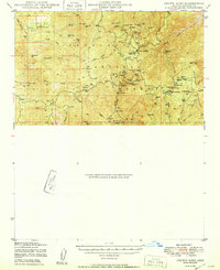
(24)- 1950 Map of Paulden
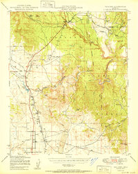 1950 Paulden1950 Print · USGSYavapai County ranching and rail infrastructure are captured here in the mid-twentieth century as the high desert settlements expanded. Researchers can trace the path of the Atchison Topeka and Santa Fe through Drake and locate family landmarks like Stewart Ranch and Hubbel Ranch.2 unique versions available
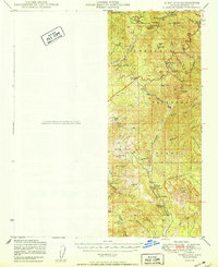
 - 1950 Map of Sheridan Mountain
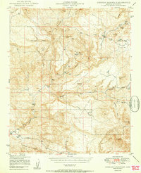 1950 Sheridan Mountain1950 Print · USGSYavapai County's high mesa ranching country is captured here during the post-war era within the Prescott National Forest. Genealogists and historians can locate established livestock operations like Spider Ranch, Dumbbell Ranch, and the Yolo Cabin.2 unique versions available
 - 1950 Map of Wagoner
 1950 Wagoner1950 Print · USGSYavapai County ranching life is preserved in this mid-century survey of the Arizona interior as it appeared just after the war. Researchers can trace the layout of the Diamond 2 Ranch, the isolated settlement of Minnehaha, and the winding course of the Hassayampa River.2 unique versions available
 - 1950 Map of Turkey Canyon
 1950 Turkey Canyon1950 Print · USGSThe Juniper Mountains and Prescott National Forest appear in the mid-century as a land of ranching outposts and massive land grants. Researchers can trace the layout of the Luis Maria Baca Float No 5 and locate local sites like Happy Camp and Lower Corrals.2 unique versions available
 - 1950 Map of Crown King
 1950 Crown King1950 Print · USGSThe high Bradshaw Mountains come to life in this mid-century survey of the Arizona interior. Genealogists and mining historians can trace dozens of mountain claims like the Crown King Mine and Algonquin Mine, alongside camps like Fort Misery.
 - 1950 Map of Kirkland
 1950 Kirkland1950 Print · USGSYavapai County ranching and mining operations are captured in detail at mid-century as the region's rural economy transitioned. Trace family history at the Walnut Grove School or locate old diggings like the Climax Mine and Cooper Crown Mine.
 - 1950 Map of Picacho Butte
 1950 Picacho Butte1950 Print · USGSYavapai County ranching and forest lands are captured here at mid-century, before modernization altered the high-desert range. Researchers can trace historic operations at the K4 Farm and CV Ranch or locate the old Stone Quarry and Mexican Dam.
 - 1950 Map of Bumblebee
 1950 Bumblebee1950 Print · USGSMining operations and remote settlements define this central Arizona landscape during the late nineteen-forties. Researchers can trace the era's mineral wealth through sites like the Thunderbolt Mine and Howard Copper Mine, or locate family landmarks near Bumblebee and Poland.
 - 1950 Map of Simmons
 1950 Simmons1950 Print · USGSYavapai County ranching country is captured here during the post-war era of the late 1940s. Genealogists and historians can trace significant family holdings like Seven V Ranch and Las Vegas Ranch or locate landmarks such as Inscription Canyon.2 unique versions available
 - 1950 Map of Prescott, 1951 Print
 1950 Prescott1951 Print · USGSArizona's mining and ranching frontiers were in full operation during the early fifties, from the vertical streets of Jerome to the remote western desert. Genealogists and researchers can trace rural life via the Bland School, the United Verde Mine, and stops along the Atchison Topeka and Santa Fe Railway.
 - 1954 Map of Prescott, 1963 Print
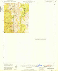
 1954 Prescott1963 Print · USGSYavapai County mining and ranching districts are shown in high detail during the mid-twentieth century. Researchers can trace the legacy of remote camps and transport hubs like Swansea, Octave, and the Bagdad Mine along the desert rail lines.4 unique versions available
 - 1954 Map of Phoenix, 1964 Print
 1954 Phoenix1964 Print · USGSMid-century Arizona is captured here as the Phoenix metropolitan area begins its rapid expansion into the surrounding desert. Genealogists and historians can trace the development of agricultural hubs like Buckeye and Tolleson, or locate remote landmarks like the Vulture Mine and Nottbusch Cem.5 unique versions available
 - 1954 Map of Holbrook, 1966 Print
 1954 Holbrook1966 Print · USGSNorth-central Arizona is seen here during the mid-fifties, from the high plateau of the Mogollon Rim to the Verde Valley. Researchers can trace the early growth of Holbrook, locate remote camps like Happy Jack, and explore the roads around Montezuma Castle National Monument.3 unique versions available
 - 1954 Map of Mesa, 1968 Print
 1954 Mesa1968 Print · USGSCentral Arizona in the mid-fifties reveals the rapid growth of the Valley of the Sun alongside the deep-rooted mining districts of the eastern mountains. Genealogists and researchers can trace the expansion of Mesa and Chandler or locate legacy operations at Inspiration Mine and the Magma Arizona railroad.4 unique versions available
 - 1954 Map of Williams, 1972 Print
 1954 Williams1972 Print · USGSThe high plateau of Northern Arizona is captured here during the mid-fifties, showing the rail-and-road corridor before the interstate era. You can trace family roots through remote railroad stops like Audley and Pica or locate early landmarks such as Grand Canyon Caverns and Frazier Wells.
 - 1956 Map of Williams, 1963 Print
 1956 Williams1963 Print · USGSNorthern Arizona in the mid-fifties reveals a landscape shaped by the Atchison Topeka and Santa Fe railroad and the iconic Highway 66. Trace the route of early travelers through Peach Springs, Seligman, and Ash Fork, or find remote sites like the Music Mountain Mine (Gold).3 unique versions available
 - 1957 Map of Mesa
 1957 Mesa1957 Print · USGSCentral Arizona's desert valleys and high-mountain mining districts come alive in the mid-fifties. Researchers can trace the early layout of Mesa and Phoenix or locate remote sites like Inspiration Mine and Arizona State College.
 - 1957 Map of Phoenix
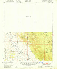
 1957 Phoenix1957 Print · USGSGreater Phoenix and the central Arizona desert during the mid-fifties reveal a landscape of growing suburbs and active desert mines. Researchers can trace the legacy of local landmarks like Wickenburg Prison, the Vulture Mine, and the Tonopah Post Office.
 - 1957 Map of Holbrook
 1957 Holbrook1957 Print · USGSNorthern Arizona in the mid-fifties is defined by the high-plateau timberlands and the bustling rail corridor of the Little Colorado River valley. Genealogists and historians can trace the route of U.S. 66 through Holbrook or locate more remote outposts like Zeniff and Aripine.
 - 1958 Map of Mesa
 1958 Mesa1958 Print · USGSMid-century Arizona comes alive in this survey of the valley and high desert, where urban growth begins to transform the landscape. Genealogists and researchers can trace the rail-and-mine economy through Inspiration Mine and old stops like Rittenhouse and Magma.
 - 1958 Map of Holbrook
 1958 Holbrook1958 Print · USGSNortheastern Arizona's high country is captured here during the mid-fifties, showing the growth of mountain towns and timber lands. Researchers can trace the Atchison Topeka & Santa Fe RR through Holbrook or find vanished spots like Zeniff.
 - 1958 Map of Prescott
 1958 Prescott1958 Print · USGSCentral Arizona's rugged mining and ranching corridors come alive in the late fifties. Genealogists and historians can trace the remote Trout Creek School, the mining operations at Jerome, and the rail stops at Skull Valley and Kirkland.
 - 1958 Map of Phoenix
 1958 Phoenix1958 Print · USGSThe Phoenix Valley enters a period of postwar expansion, where desert irrigation meets massive military aviation footprints. Trace the development of Phoenix and Glendale alongside the legendary Vulture Mine and the auxiliary runways of Luke Air Force Base.
 - 1959 Map of Prescott
 1959 Prescott1959 Print · USGSYavapai County and the central Arizona highlands come alive in the late fifties, showcasing a landscape of mountain mining towns and forest outposts. Researchers can trace the industrial footprints of the United Verde Mine, follow the Atchison Topeka and Santa Fe rails, and locate remote settlements like Swansea or Skull Valley.2 unique versions available
End of results
Showing maps 1-24 of 24
Top cities of Yavapai County
- Prescott historical maps
- Prescott Valley historical maps
- Cottonwood historical maps
- Camp Verde historical maps
- Williamson historical maps
- Paulden historical maps
See more
Frequently asked questions
- What are the different types of historical maps available for Yavapai County?
- What is the oldest map of Yavapai County?
- Where can I purchase historical maps of Yavapai County for my home or office?
- Where can I download high-res historical maps of Yavapai County?
- Are there historical topographic maps available for Yavapai County?
- Is there historical aerial imagery available for Yavapai County?
- Where are historical maps of Yavapai County sourced from?