1910s Maps of Arkansas
Explore 5 historic maps of Arkansas from the 1910s. These maps offer a rare glimpse into what life looked like during the 1910s — showing old roads, neighborhoods, homes, and landmarks that have changed or disappeared over time.
Whether you're researching your family's past, planning a metal detecting trip, or studying how Arkansas's landscape evolved across the 1910s, these high-resolution maps are a powerful tool for exploring the history of this region.
- Focus on a specific era: All maps on this page are from the 1910s, giving you a focused view of this time period.
- See what’s changed: Compare century-old streets, trails, and buildings to today's modern landscape using overlays and satellite layers.
- Research with precision: Use these maps for genealogy, historical research, land use analysis, or educational projects.
- View, download, or print: Maps are fully viewable online in high resolution, and can be downloaded or printed for your own records.
Start exploring Arkansas's history through authentic maps from the 1910s. This is your window into the past.
Arkansas maps
(5)- 1910 Map of Atlanta
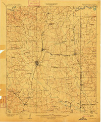 1910 Atlanta1910 Print · USGSNortheast Texas at the height of the timber boom is captured here, showing the intricate network of sawmills and rail lines crossing into Arkansas and Louisiana. Genealogists can locate family landmarks like Laws Chapel, Hosey's Store, and the Henderson Hill School among the many rural settlements.2 unique versions available
 - 1912 Map of Lake Cormorant
 1912 Lake Cormorant1912 Print · USGSDeSoto County and the Mississippi-Tennessee border are shown here in the early twentieth century as the rail-and-river economy flourished. Genealogists and local historians can trace the foundations of Lake Cormorant, locate the Morning Star Church, and find river landings like Norfolk Landing.3 unique versions available
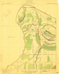
 - 1912 Map of Moon Lake
 1912 Moon Lake1912 Print · USGSThe Mississippi Delta's intricate river-and-rail landscape is preserved here during the early twentieth century. Genealogists and local historians can trace the foundations of the area through the Yazoo and Mississippi Valley R R and rural settlements like Powell and Delta Gerald P O.3 unique versions available
 - 1913 Map of De Queen
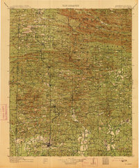 1913 De Queen1913 Print · USGSThe southern Ouachita Mountains and the Arkansas-Oklahoma borderlands appear here in the early twentieth century as the railroad transformed the timber and mining industries. Researchers can trace historic sites like the Welcome Home School, the Kansas City Southern RR corridor, and the early streets of De Queen.4 unique versions available
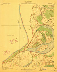
 - 1916 Map of Memphis, 1954 Print
 1916 Memphis1954 Print · USGSMemphis and the Mississippi River bottomlands appear here in the early twentieth century, showing a landscape shaped by river transport and rail expansion. Genealogists and historians can locate rural landmarks like Barton Store, the Levi School, and the community of Mound City.
End of results
Showing maps 1-5 of 5
Top cities of Arkansas
- Little Rock historical maps
- Fayetteville historical maps
- Fort Smith historical maps
- Springdale historical maps
- Jonesboro historical maps
- Rogers historical maps
See more
Top counties of Arkansas
- Pulaski County historical maps
- Benton County historical maps
- Washington County historical maps
- Sebastian County historical maps
- Faulkner County historical maps
- Saline County historical maps
See more
Frequently asked questions
- What are the different types of historical maps available for Arkansas?
- What is the oldest map of Arkansas?
- Where can I purchase historical maps of Arkansas for my home or office?
- Where can I download high-res historical maps of Arkansas?
- Are there historical topographic maps available for Arkansas?
- Is there historical aerial imagery available for Arkansas?
- Where are historical maps of Arkansas sourced from?