1900s (20th Century) Maps of Arkansas
Explore 1,585 historic maps of Arkansas from the 1900s (20th Century). These maps offer a rare glimpse into what life looked like during the 1900s — showing old roads, neighborhoods, homes, and landmarks that have changed or disappeared over time.
Whether you're researching your family's past, planning a metal detecting trip, or studying how Arkansas's landscape evolved across the 1900s, these high-resolution maps are a powerful tool for exploring the history of this region.
- Focus on a specific era: All maps on this page are from the 1900s, giving you a focused view of this time period.
- See what’s changed: Compare century-old streets, trails, and buildings to today's modern landscape using overlays and satellite layers.
- Research with precision: Use these maps for genealogy, historical research, land use analysis, or educational projects.
- View, download, or print: Maps are fully viewable online in high resolution, and can be downloaded or printed for your own records.
Start exploring Arkansas's history through authentic maps from the 1900s. This is your window into the past.
Arkansas maps
(1,585)- 1900 Map of Eureka Springs, 1954 Print
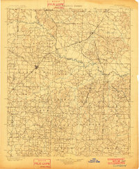
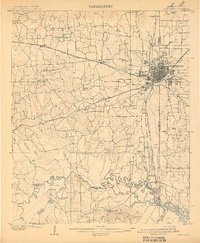
 1900 Eureka Springs1954 Print · USGSThe Ozark Mountains around the Arkansas and Missouri border are shown here during the turn of the century, when the river-and-rail economy was firmly established. Researchers can locate early family crossings and landmarks like Knox Ferry, Pivot Rock, and the St. Louis & San Francisco R. R.
 - 1901 Map of Winslow
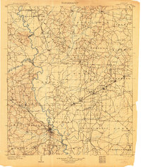
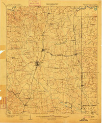
 1901 Winslow1901 Print · USGSThe Boston Mountains and the Arkansas border are captured here at the close of the nineteenth century, documenting the critical rail passage through the Ozarks. Genealogists and historians can trace the Frisco Line, the historic Old Wire Road, and early settlements like Cove City and Cane Hill.5 unique versions available
 - 1901 Map of Marshall
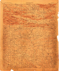
 1901 Marshall1901 Print · USGSThe Ozark plateau in the 1890s reveals a rugged network of high ridges and river forks where isolation defined early settlement. Genealogists can trace family roots through upland communities like Snowball, Witts Springs, and Wileys Cove before modern infrastructure reached the Boston Mountain range.4 unique versions available
 - 1901 Map of Eureka Springs
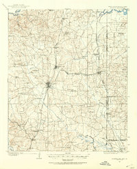
 1901 Eureka Springs1901 Print · USGSThe Arkansas Ozarks at the turn of the century are captured here in a time of river ferries and mountain townships. Genealogists and historians can locate early settlements like Eureka Springs and Berryville, or trace historic crossings such as Knox Ferry and Ellis Ford.3 unique versions available
 - 1901 Map of Fayetteville
 1901 Fayetteville1901 Print · USGSNorthwest Arkansas is seen here at the start of the twentieth century as railroads and trade began to reshape the Ozark foothills. Researchers can locate the Pea Ridge Battlefield and Elkhorn Tavern, or trace early industrial sites like Osage Mills and Rhea's Mill.4 unique versions available
 - 1901 Map of Gurdon
 1901 Gurdon1901 Print · USGSSouthwest Arkansas at the dawn of the twentieth century was a landscape defined by the arrival of the rails and the timber industry. Researchers can trace the development of early rail towns like Gurdon, Prescott, and Whelen Springs along the St. Louis Iron Mountain and Southern R. R.3 unique versions available
 - 1901 Map of Tahlequah
 1901 Tahlequah1901 Print · USGSTahlequah and the Cherokee Nation are captured here during the final years of the Indian Territory era. Genealogists can locate family landmarks such as the Female Seminary, Elm Springs Mission, and the rail-stop settlements of Stilwell and Wauhillau.8 unique versions available
 - 1903 Map of Yellville
 1903 Yellville1903 Print · USGSNorth Central Arkansas in the late nineteenth century is a land of winding river valleys and ridge-top settlements. Genealogists can trace early homesteads and river crossings like Denton Ferry, Yellville, and the remote outposts of Dodd City or St. Joe.
 - 1903 Map of Camden
 1903 Camden1903 Print · USGSSouth Arkansas at the turn of the century reveals a landscape of river-bend commerce and emerging rail towns along the Ouachita River. Trace family roots in early settlements like Holly Springs, Bearden, and the industrial hub at Eagle Mills.3 unique versions available
 - 1903 Map of Siloam Springs, 1904 Print
 1903 Siloam Springs1904 Print · USGSThe border of Arkansas and the Cherokee Nation comes to life in this survey from the turn of the century. Genealogists and historians can trace the early layout of Siloam Springs or locate small landmarks like Shoaps Store and Round Spring Church.
 - 1904 Map of Siloam Springs
 1904 Siloam Springs1904 Print · USGSThe Arkansas and Indian Territory borderlands are captured here at the turn of the century, prior to Oklahoma statehood. Researchers can trace the early layout of Siloam Springs and locate vanished landmarks like Shoaps Store or the Round Spring Church.7 unique versions available
 - 1904 Map of Fayetteville
 1904 Fayetteville1904 Print · USGSNorthwest Arkansas was a land of emerging railroads and Civil War memory at the turn of the century. Genealogists can locate family homesteads near Rhea's Mill, the Pea Ridge Battlefield, and early river crossings like Vanwinkle Ferry.
 - 1904 Map of Harrison, 1954 Print
 1904 Harrison1954 Print · USGSThe Ozark Mountains of Northwest Arkansas are documented here at the turn of the century, showing a landscape of pioneer settlements and new rail lines. Genealogists can trace early homesteads and commerce at Blantons Mill, the village of Carrollton, and the regional hub of Harrison.
 - 1905 Map of Harrison
 1905 Harrison1905 Print · USGSThe Ozark Plateau at the start of the century was a land of winding mountain railroads and isolated creek-side settlements. Genealogists can trace family footprints across the highlands from Lead Hill to Green Forest, finding early industrial landmarks like Blantons Mill and the Rock Quarry.3 unique versions available
 - 1905 Map of Yellville
 1905 Yellville1905 Print · USGSThe Ozark Mountains and the winding White River define this area at the start of the twentieth century. Genealogists can trace family names through dozens of river crossings and small settlements like Denton Ferry, Rush, and Elixir Springs.3 unique versions available
 - 1905 Map of Tahlequah
 1905 Tahlequah1905 Print · USGSTahlequah and the surrounding Cherokee Nation are captured here in the years before Oklahoma statehood. Researchers can trace the early rail routes and find historic sites like the Female Seminary, the Cherokee Orphan Asylum, and Elm Springs Mission.
 - 1906 Map of Batson
 1906 Batson1906 Print · USGSJohnson County highlands come into focus in the early 1900s through this rare advance sheet of the southern Batson area. Local historians can trace the early layout of Harmony, Hunt, and Grace near the waters of the East Fork of Horse Head Creek.
 - 1906 Map of Caddo Gap
 1906 Caddo Gap1906 Print · USGSWest-central Arkansas at the dawn of the twentieth century shows a rugged landscape defined by the Ouachita ridges and early mountain industries. Researchers can trace defunct mining communities like Slatington and Fancy Hill, or locate long-gone railway stops at Hickory Station and Brocktown.3 unique versions available
 - 1906 Map of Lavaca
 1906 Lavaca1906 Print · USGSThe Arkansas River valley comes to life in the late nineteenth century as railroads and ridges define the growing settlements of Sebastian County. Researchers can trace the original locations of Lavaca, Alma, and Vesta, or locate family-named landmarks like Butler's Knob and Arbuckles Island.
 - 1906 Map of Barber
 1906 Barber1906 Print · USGSSebastian County’s ridges and valley settlements are shown here at the start of the twentieth century, during a time of rural expansion. Researchers can trace early family sites and commerce through landmarks like the Toll Bridge and settlements such as Burnville and Sulphur Spring.
 - 1907 Map of Atlanta, 1954 Print
 1907 Atlanta1954 Print · USGSNorthwest Louisiana and Northeast Texas meet in this early century survey of the rail-and-timber corridor surrounding Atlanta. Researchers can trace the heritage of rural communities through dozens of local landmarks like Laws Chapel, Pritchard's Gin, and the Cass Lumber Co Sawmill.2 unique versions available
 - 1908 Map of Moon Lake, 1961 Print
 1908 Moon Lake1961 Print · USGSThe Mississippi Delta's oxbows and bayous are meticulously detailed here in the early 1900s, showing a river-driven landscape. Trace the old rail lines of the Yazoo and Mississippi Valley R R or locate local centers like Delta Gerald P O and Powell.
 - 1908 Map of Lake Cormorant, 1961 Print
 1908 Lake Cormorant1961 Print · USGSThe Mississippi Delta's shifting landscape is captured here in the early twentieth century, showing a world of river landings and new rail lines. Genealogists and historians can trace the foundations of Lake Cormorant, Glover, and the Morning Star Church.
 - 1909 Map of Texarkana
 1909 Texarkana1909 Print · USGSTexarkana emerged as a bustling tri-state rail center at the dawn of the twentieth century, defined by its complex web of iron roads and river commerce. Genealogists and local historians can trace family roots at White Chapel, the Stateline Ferry, and rural sites like Alamo Mills.5 unique versions available
 - 1910 Map of Atlanta
 1910 Atlanta1910 Print · USGSNortheast Texas at the height of the timber boom is captured here, showing the intricate network of sawmills and rail lines crossing into Arkansas and Louisiana. Genealogists can locate family landmarks like Laws Chapel, Hosey's Store, and the Henderson Hill School among the many rural settlements.2 unique versions available
Showing maps 1-25 of 1,585
Top cities of Arkansas
- Little Rock historical maps
- Fayetteville historical maps
- Fort Smith historical maps
- Springdale historical maps
- Jonesboro historical maps
- Rogers historical maps
See more
Top counties of Arkansas
- Pulaski County historical maps
- Benton County historical maps
- Washington County historical maps
- Sebastian County historical maps
- Faulkner County historical maps
- Saline County historical maps
See more
Frequently asked questions
- What are the different types of historical maps available for Arkansas?
- What is the oldest map of Arkansas?
- Where can I purchase historical maps of Arkansas for my home or office?
- Where can I download high-res historical maps of Arkansas?
- Are there historical topographic maps available for Arkansas?
- Is there historical aerial imagery available for Arkansas?
- Where are historical maps of Arkansas sourced from?