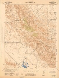
1940s Maps of Kern County, California
Explore 90 historic maps of Kern County from the 1940s. These maps offer a rare glimpse into what life looked like during the 1940s — showing old roads, neighborhoods, homes, and landmarks that have changed or disappeared over time.
Whether you're researching your family's past, planning a metal detecting trip, or studying how Kern County's landscape evolved across the 1940s, these high-resolution maps are a powerful tool for exploring the history of this region.
- Focus on a specific era: All maps on this page are from the 1940s, giving you a focused view of this time period.
- See what’s changed: Compare century-old streets, trails, and buildings to today's modern landscape using overlays and satellite layers.
- Research with precision: Use these maps for genealogy, historical research, land use analysis, or educational projects.
- View, download, or print: Maps are fully viewable online in high resolution, and can be downloaded or printed for your own records.
Start exploring Kern County's history through authentic maps from the 1940s. This is your window into the past.
Kern County, CA maps
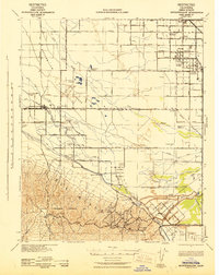
(90)- 1940 Map of Oil Center
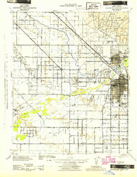
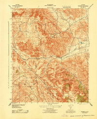
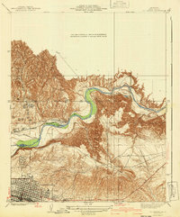 1940 Oil Center1940 Print · USGSBakersfield and its surrounding oil fields are caught here at a moment of intense industrial development during the late thirties and early fourties. Genealogists and researchers can trace local landmarks like Oil Center, the County Hospital, and several rural schools including Petroleum Sch.2 unique versions available
 - 1940 Map of Reynolds Ranch
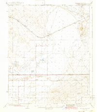
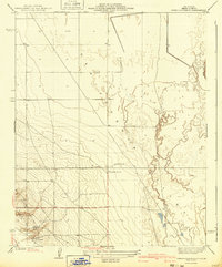 1940 Reynolds Ranch1940 Print · USGSKern County ranching and early irrigation projects are preserved here in the years leading up to the mid-century. Genealogists and local historians can trace the footprints of Reynolds Ranch, Gilbert Ranch, and the path of the Goose Lake Canal.
 - 1942 Map of Slater
 1942 Slater1942 Print · USGSKern County during the early war years shows an landscape of evolving rail towns and major irrigation works. Genealogists and historians can trace the early footprints of McFarland and Famoso, alongside family holdings like the Doyle Ranch and Kimberlina Ranch.
 - 1942 Map of Earlimart
 1942 Earlimart1942 Print · USGSThe southern San Joaquin Valley comes alive in the early 1940s, showing a grid of irrigation canals and major rail lines. Genealogists and historians can trace the foundations of Allensworth, locate numerous sportsmen's outposts like the Widgeon Gun Club, and follow the historic Southern Pacific route.2 unique versions available
 - 1942 Map of Buttonwillow
 1942 Buttonwillow1942 Print · USGSKern County's agricultural and energy heartland is meticulously detailed in this wartime survey of the San Joaquin Valley. Researchers can trace family ranch boundaries like Woolner Ranch, locate the Rio Bravo Oil Field, and follow the Southern Pacific McKittrick Branch rail line.
 - 1942 Map of Kramer
 1942 Kramer1942 Print · USGSThe high desert comes into focus in the 1930s and 40s as rail transit and early aviation began to shape this corner of San Bernardino. You can trace the Atchison Topeka and Santa Fe tracks through Amargo or find the remote Blake Ranch and Kramer.2 unique versions available
 - 1942 Map of Liberty Farms
 1942 Liberty Farms1942 Print · USGSThe reclaimed basin of Kings County is shown at the height of its early industrial ranching era, just after the turn of the decade. Genealogists and historians can trace the vast holdings of Harvester Ranch, Hacienda Ranch, and the Westlake Gun Club.2 unique versions available
 - 1942 Map of Hart Station
 1942 Hart Station1942 Print · USGSThe San Joaquin Valley during the early years of the war reveals an landscape of managed water and private sporting clubs. Genealogists and local historians can trace family-named properties like Cole Ranch and Douglas Ranch or locate the rural Semitropic Sch.
 - 1942 Map of Rogers Lake
 1942 Rogers Lake1942 Print · USGSThe Antelope Valley and Mojave Desert appear in the early 1940s as a landscape of remote ranches and emerging military ranges. Trace the early boundaries of the Muroc Bombing and Gunnery Range and find rural landmarks like Redman Sch and Solon.2 unique versions available
 - 1942 Map of Terra Bella
 1942 Terra Bella1942 Print · USGSThe San Joaquin Valley's agricultural heartland is captured here during the early 1940s, highlighting the vital rail-and-water network of the Tulare-Kern border. Researchers can trace historic family holdings like Menne Ranch or locate vanished rural schoolhouses such as Columbine Sch and Saucelito Sch.
 - 1942 Map of Bakersfield West, 1944 Print
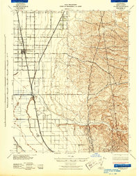
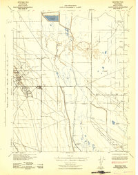
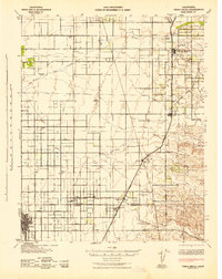
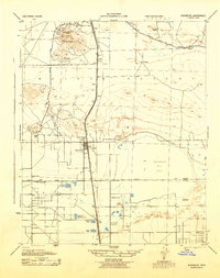
 1942 Bakersfield West1944 Print · USGSBakersfield and the surrounding oil fields are shown here during the early war years, revealing a landscape defined by petroleum and irrigation. Genealogists can locate family holdings near Rosedale, Pumpkin Center, or early schoolhouses like Greeley Sch.
 - 1942 Map of Eagle Rest Peak, 1956 Print
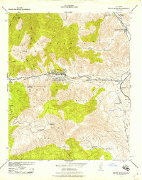
 1942 Eagle Rest Peak1956 Print · USGSThe southern San Joaquin Valley meets the high mountains of Kern County in the 1940s, showing a landscape defined by deep canyons and prominent peaks. Researchers can trace the boundaries of San Emigdio Ranch or locate landmarks like Brush Mountain and Eagle Rest Peak.5 unique versions available
 - 1942 Map of Tecuya Creek, 1957 Print
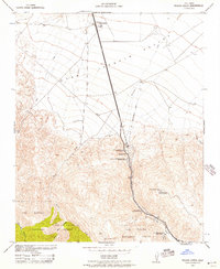 1942 Tecuya Creek1957 Print · USGSThe critical mountain pass of the Grapevine is captured here during the early 1940s as a vital energy and transport corridor. Trace the early industrial footprint of the General Petroleum Corp Rose Station and the high-altitude Kern Co Police Radio Relay Station.
 - 1942 Map of Frazier Mountain, 1957 Print
 1942 Frazier Mountain1957 Print · USGSThe mountain passes of Kern and Ventura counties were centers of mining and early petroleum transit during the 1940s. Genealogists and historians can trace family holdings at Lebec Oaks Ranch and Maxy Ranch or locate the historic Old Fort Tejon.
 - 1942 Map of Ballinger Canyon, 1958 Print
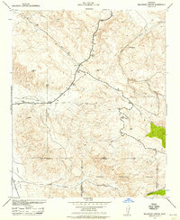 1942 Ballinger Canyon1958 Print · USGSThe high desert canyons of the California interior come to life in the early 1940s at the convergence of four county lines. Researchers can trace historic ranch sites like Klipstein Ranch and remote outposts such as Camp Dix near the Cuyama Valley floor.
 - 1942 Map of Tent Hills, 1960 Print
 1942 Tent Hills1960 Print · USGSIn the early 1940s, this pocket of the California Coast Ranges was a rugged intersection of ranch land and high ridges. Genealogists and historians can trace old homestead boundaries and early routes through Cottonwood Pass, Iron Spring Ranch, and Fahey Ranch.2 unique versions available
 - 1943 Map of Rosamond
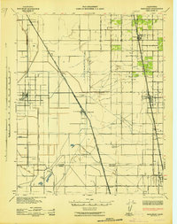
 1943 Rosamond1943 Print · USGSThe Mojave Desert comes alive in the early 1940s as a center of mining and rail transit. Researchers can trace the industrial footprint of the Golden Queen Mine, locate the Kern County Union School, and see the early layout of Rosamond.2 unique versions available
 - 1943 Map of Packwood
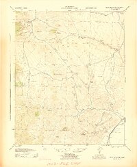
 1943 Packwood1943 Print · USGSThe Temblor Range and the border of Kern and San Luis Obispo counties are captured here during the early 1940s. Genealogists and local historians can trace isolated ranch sites like W M Cook and Sumners or locate the remote Cemetery and Bitterwater Pump Station.
 - 1943 Map of Tehachapi
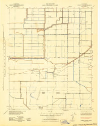
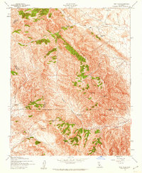
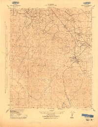
 1943 Tehachapi1943 Print · USGSTehachapi and the surrounding mountain passes are captured in the early 1940s during a period of vital rail and industrial activity. Trace the SOUTHERN PACIFIC line through the Tehachapi Pass or locate rural sites like Jameson Ranch and the Pine Tree Mine.4 unique versions available
 - 1943 Map of Grant Lake
 1943 Grant Lake1943 Print · USGSRanching outposts and high-desert canyons define this region of the California coast ranges during the early war years. Family-named landmarks such as Iverson Ranch and McIsaac can be traced alongside Choice Valley School and Grant Lake.
 - 1943 Map of Inyokern
 1943 Inyokern1943 Print · USGSInyokern and the high desert plains are shown during the mid-forties, highlighting a landscape shaped by the Southern Pacific and the Los Angeles Aqueduct. Genealogists and historians can trace old homesteads and stations like Carr Ranch, Bradys, and the Hi-Peak Mine.4 unique versions available
 - 1943 Map of Maricopa
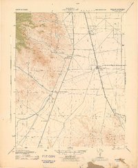
 1943 Maricopa1943 Print · USGSMaricopa and the surrounding oil fields come into sharp focus during the wartime production boom of the 1940s. Genealogists and industrial historians can trace the foundations of company towns like Spellacy and infrastructure such as the Sunset Railway or the Norwalk Oil Co Refinery.
 - 1943 Map of Tent Hills
 1943 Tent Hills1943 Print · USGSThe rugged junction of four California counties during the early 1940s is detailed here through the peaks of the Diablo Range. Genealogists and historians can trace family-named outposts like Acebedo Ranch and landmarks at Polonio Pass.
 - 1943 Map of Cross Mountain
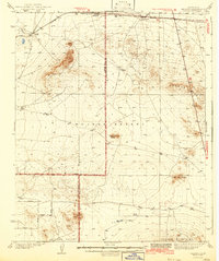
 1943 Cross Mountain1943 Print · USGSKern County's high desert reveals its mining and water-management history in the 1940s. Genealogists and researchers can trace the locations of the Landers School, the abandoned settlement of Sageland, and several historic mines including the San Antonio Mine.5 unique versions available
 - 1943 Map of Simmler
 1943 Simmler1943 Print · USGSThe high desert ranching country of the Carrizo Plain and Temblor Range is captured here during the early 1940s. Genealogists and local historians can locate early homesteads like McAllister Ranch and trace the original grounds of the Simmler School.
Showing maps 1-25 of 90
Top cities of Kern County
- Bakersfield historical maps
- Delano historical maps
- Ridgecrest historical maps
- Wasco historical maps
- Shafter historical maps
- Arvin historical maps
See more
Frequently asked questions
- What are the different types of historical maps available for Kern County?
- What is the oldest map of Kern County?
- Where can I purchase historical maps of Kern County for my home or office?
- Where can I download high-res historical maps of Kern County?
- Are there historical topographic maps available for Kern County?
- Is there historical aerial imagery available for Kern County?
- Where are historical maps of Kern County sourced from?