1990s Maps of Montrose County, Colorado
Explore 21 historic maps of Montrose County from the 1990s. These maps offer a rare glimpse into what life looked like during the 1990s — showing old roads, neighborhoods, homes, and landmarks that have changed or disappeared over time.
Whether you're researching your family's past, planning a metal detecting trip, or studying how Montrose County's landscape evolved across the 1990s, these high-resolution maps are a powerful tool for exploring the history of this region.
- Focus on a specific era: All maps on this page are from the 1990s, giving you a focused view of this time period.
- See what’s changed: Compare century-old streets, trails, and buildings to today's modern landscape using overlays and satellite layers.
- Research with precision: Use these maps for genealogy, historical research, land use analysis, or educational projects.
- View, download, or print: Maps are fully viewable online in high resolution, and can be downloaded or printed for your own records.
Start exploring Montrose County's history through authentic maps from the 1990s. This is your window into the past.
Montrose County, CO maps
(21)- 1994 Map of Davis Point
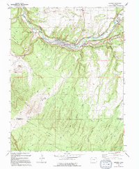
 1994 Davis Point1994 Print · USGSThe Uncompahgre plateau in the early nineties remains a landscape of high mesas and deep creek basins. Map collectors and historians can trace the Old Railroad Grade and remote forest routes like the Cushman Road and Roubideau Trail.
 - 1994 Map of Ute
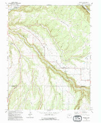
 1994 Ute1994 Print · USGSMontrose County was a landscape of high-country ranching and forest management during the 1990s. Genealogists and historians can trace the remote operations of the Basin Work Center, the Houser Cow Camp, and the seasonal importance of Monument Lake.
 - 1994 Map of Naturita
 1994 Naturita1994 Print · USGSNaturita and the San Miguel River valley are captured here in the mid-1990s, illustrating a landscape shaped by both water and mining. Researchers can trace irrigation networks like the Parkway Ditch or locate local landmarks including the High School and Hopkins-Montrose County Airport.
 - 1994 Map of Redvale
 1994 Redvale1994 Print · USGSWrights Mesa and the canyon lands of western Colorado are shown here in the mid-1990s, when irrigation ditches still defined the local agriculture. Researchers can trace rural settlement patterns through the Coventry Cem and the small communities of Redvale and Coventry.
 - 1994 Map of Moore Mesa
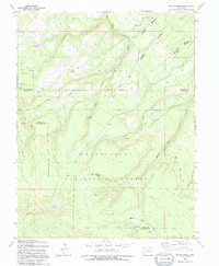
 1994 Moore Mesa1994 Print · USGSMontrose County was a landscape of high-altitude ranching and forest management during the 1990s. Researchers can locate seasonal outposts like 41 Cow Camp and trace mountain routes like the Monitor Mesa Road or Roubideau Trail.
 - 1994 Map of Red Canyon
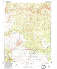
 1994 Red Canyon1994 Print · USGSThe canyon country of Western Colorado is shown here at a peak of industrial use during the 1990s. Trace the history of the Cold War uranium boom through the Department of Energy Uranium Reserve and remote sites like the King Solomon Mine and Shamrock Mines.
 - 1994 Map of Davis Mesa
 1994 Davis Mesa1994 Print · USGSIn the 1990s, this area of the Colorado plateau shows a landscape heavily shaped by mineral extraction within the Department of Energy Uranium Reserve. Genealogists and industrial historians can trace dozens of specific claims, including the Hidden Basin Mine, Florence Nellie Mine, and Black Shot Mine.
 - 1994 Map of Windy Point
 1994 Windy Point1994 Print · USGSMontrose County in the 1990s is captured here as a landscape of high-country grazing and remote aviation facilities. Trace the pack routes used by ranchers through Porters Cow Camp, locate the forest Landing Strip, and follow old paths like the Burro Trail.
 - 1994 Map of Dry Creek Basin
 1994 Dry Creek Basin1994 Print · USGSMontrose County in the mid-1990s reveals a specialized landscape of irrigation and water management across the Shavano Valley. Trace the paths of the West Canal and discover infrastructure like the Olathe Reservoir No 1 and local markers like the Temple Park Highway.
 - 1994 Map of Big Bucktail Creek
 1994 Big Bucktail Creek1994 Print · USGSMontrose County was still being actively shaped by mining and irrigation in the early nineties. You can trace the path of the San Miguel River and locate remote landmarks like the Cem and various Mines tucked into the canyon walls.
 - 1994 Map of Roc Creek
 1994 Roc Creek1994 Print · USGSMontrose County was a landscape of canyons and mines in the 1990s, defined by the Dolores River. Trace mining history at the Barium Cycle Mine or Sunrise Mine, and locate the Pace Ranch or the Radium Trail.
 - 1994 Map of Antone Spring
 1994 Antone Spring1994 Print · USGSHigh-altitude grazing lands and forest service routes define this Montrose County landscape in the early nineties. Researchers can trace historic seasonal outposts like Gray Cow Camp and Lary Y Cow Camp or explore remote paths such as the Roubideau Trail.
 - 1994 Map of Naturita NW
 1994 Naturita NW1994 Print · USGSWestern Colorado's uranium mining legacy is captured here in the mid-1990s, centering on the canyonlands and mesas of Montrose and San Miguel Counties. Researchers can locate extraction sites like the Thunderbolt Mine and the sprawling Department of Energy Uranium Reserve.
 - 1994 Map of Atkinson Creek
 1994 Atkinson Creek1994 Print · USGSMontrose and Mesa counties during the 1990s show a landscape of high mesas and heavy mineral extraction. Trace the industrial footprint of the Uranium Reserve near the San Miguel River and the remote Spring Creek Ranch.
 - 1994 Map of Anderson Mesa
 1994 Anderson Mesa1994 Print · USGSThe high mesas of Montrose and San Miguel counties are captured here in the 1990s, revealing a landscape defined by deep river canyons and remote mining claims. Researchers can trace the geography of local industry through sites like the Morning Star Mine, Raven Mine, and the winding Dolores River.
 - 1994 Map of Uravan
 1994 Uravan1994 Print · USGSMining operations dominate this stretch of the San Miguel River in the 1990s. Researchers can locate named sites like Sunbeam Mine and the Department of Energy Uranium Reserve.
 - 1994 Map of Pryor Creek
 1994 Pryor Creek1994 Print · USGSThe high country of the Uncompahgre Plateau is captured in the 1990s as it straddles the Montrose and Ouray county lines. Trace historic travel routes like the Old Paradox Road and locate remote outposts such as Silesca Guard Sta and Donley Camp.
 - 1994 Map of Starvation Point
 1994 Starvation Point1994 Print · USGSMontrose and Mesa counties are shown during the mid-1990s, revealing a landscape of high-altitude ranching and forest management. Researchers can trace historic grazing sites like Dillard Cow Camp or locate the Copper King Mine near Starvation Point.
 - 1994 Map of Nucla
 1994 Nucla1994 Print · USGSThe high desert plateau surrounding Nucla is captured here in the mid-1990s, showcasing a landscape defined by irrigation and resource extraction. Researchers can trace the town's footprint, from the Nucla Cemetery and High Sch to industrial sites like the Strip Mine and Nix Mine.
 - 1994 Map of Bull Canyon
 1994 Bull Canyon1994 Print · USGSThe Colorado plateau during the mid-1990s was a landscape defined by its deep mining roots and rugged uranium reserves. Researchers can trace historic extraction sites like the Monogram Mine and Wedding Bell Mine or locate the site of Indian Henrys Cabin.
 - 1994 Map of Paradox
 1994 Paradox1994 Print · USGSParadox Valley in the 1990s remained a landscape defined by its mining heritage and unusual drainage. Geologists and local historians can trace the Cashin Mine, the Paradox Cem, and operations like the Morning Glory Mine.
End of results
Showing maps 1-21 of 21
Top cities of Montrose County
Frequently asked questions
- What are the different types of historical maps available for Montrose County?
- What is the oldest map of Montrose County?
- Where can I purchase historical maps of Montrose County for my home or office?
- Where can I download high-res historical maps of Montrose County?
- Are there historical topographic maps available for Montrose County?
- Is there historical aerial imagery available for Montrose County?
- Where are historical maps of Montrose County sourced from?