1950s Maps of Idaho
Explore 269 historic maps of Idaho from the 1950s. These maps offer a rare glimpse into what life looked like during the 1950s — showing old roads, neighborhoods, homes, and landmarks that have changed or disappeared over time.
Whether you're researching your family's past, planning a metal detecting trip, or studying how Idaho's landscape evolved across the 1950s, these high-resolution maps are a powerful tool for exploring the history of this region.
- Focus on a specific era: All maps on this page are from the 1950s, giving you a focused view of this time period.
- See what’s changed: Compare century-old streets, trails, and buildings to today's modern landscape using overlays and satellite layers.
- Research with precision: Use these maps for genealogy, historical research, land use analysis, or educational projects.
- View, download, or print: Maps are fully viewable online in high resolution, and can be downloaded or printed for your own records.
Start exploring Idaho's history through authentic maps from the 1950s. This is your window into the past.
Idaho maps
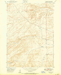
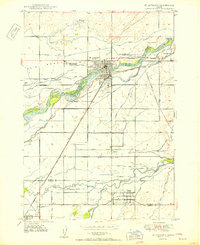
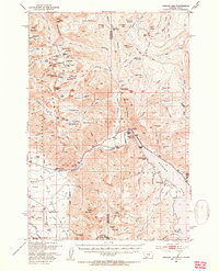
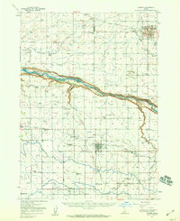
(269)- 1950 Map of Ririe
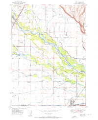 1950 Ririe1950 Print · USGSSoutheast Idaho at mid-century reveals a landscape transformed by the Snake River and its vast irrigation network. Researchers can trace family ties through Ririe and Sunnydell, or locate rural landmarks like Clark Sch and Sutton Cem.3 unique versions available
 - 1950 Map of Gooding Butte
 1950 Gooding Butte1950 Print · USGSThe high-desert terrain of Gooding County is revealed in this mid-century survey as the region developed its irrigation and rail networks. Genealogists and researchers can trace the course of the Union Pacific through Fuller or locate landmarks like Gooding Butte.2 unique versions available
 - 1950 Map of Shattuck Butte
 1950 Shattuck Butte1950 Print · USGSBonneville County in the late 1940s and early 1950s was a landscape defined by industrial quarrying and a complex irrigation network. Genealogists and researchers can trace the water rights and land use of Oakland Valley through markers like Oakland Canal, Shattuck Butte, and the Beckman Ditch.
 - 1950 Map of Parker
 1950 Parker1950 Print · USGSThe northern Snake River Plain comes into focus in this midcentury survey as agricultural irrigation meets the shifting Sand Dunes. Genealogists and historians can trace the irrigation networks of the St Anthony Canal, settlements like Parker, and the Fort Henry Historic Monument.
 - 1950 Map of Rexburg
 1950 Rexburg1950 Print · USGSRexburg and its surrounding irrigation district are shown at mid-century, just as the local economy was anchored by the railway and college. Genealogists and researchers can locate Ricks College, the Independence Ward Ch, and family plots in Rexburg Cem.
 - 1950 Map of Woodville
 1950 Woodville1950 Print · USGSSoutheast Idaho at mid-century reveals a landscape divided between the ancient Lava flows and a burgeoning agricultural network. Researchers can trace the development of irrigation systems like the Great Western Canal and locate the Woodville Cem near the banks of the Snake River.
 - 1950 Map of Newdale
 1950 Newdale1950 Print · USGSEastern Idaho’s agricultural heartland is captured here in the 1950s, showing the complex irrigation network between the Teton River and Fall River. Researchers can trace the Union Pacific rail lines and early road systems connecting Newdale and Chester.
 - 1950 Map of Oreana
 1950 Oreana1950 Print · USGSOreana and the Owyhee desert are captured here at the start of the fifties, showing the remote settlement patterns of southern Idaho. Genealogists and historians can locate the Oreana School, the local PO, and landmarks like Fossil Butte or the Cem.
 - 1950 Map of Roberts
 1950 Roberts1950 Print · USGSMid-century Jefferson County agriculture is centered on the settlement of Roberts during a period of heavy reliance on rail and irrigation. Researchers can trace the path of the Union Pacific or the complex water network of Taylor Slough and Larsen Ditch.
 - 1950 Map of Idaho Falls South
 1950 Idaho Falls South1950 Print · USGSThe Snake River Plain south of Idaho Falls reveals an intricate mid-century network of irrigation canals and rural school districts. Genealogists can locate family landmarks like New Sweden Cemetery, the LDS Temple, and the Riverdale Sch (Aband'd).
 - 1950 Map of Hagerman
 1950 Hagerman1950 Print · USGSThe Hagerman Valley at mid-century is a landscape defined by the Snake River's power and a complex network of irrigation. Researchers can trace early water rights through the Big Bend Ditch, locate the Buckeye Ranch, or study the Idaho State Fish Hatchery.
 - 1950 Map of Bliss
 1950 Bliss1950 Print · USGSThe rail-and-river landscape of southern Idaho is captured here at mid-century, centered on the town of Bliss. Genealogists and historians can trace the Union Pacific (Oregon Short Line) and local landmarks like the Cem and Bliss Reservoir.
 - 1950 Map of St Anthony
 1950 St Anthony1950 Print · USGSMid-century Fremont County is defined here by the meeting of the Henrys Fork and the Teton River amidst a massive irrigation network. Researchers can trace the Union Pacific rail line through St. Anthony and locate the Idaho Industrial Training School or Riverview Cemetery.3 unique versions available
 - 1950 Map of Indian Butte
 1950 Indian Butte1950 Print · USGSThe high Idaho desert south of the Snake River is captured here in the mid-century, defined by its role as a sprawling Aerial Gunnery Range. Researchers can trace old routes like the Castleford Road and explore landmarks like Indian Butte.
 - 1950 Map of Mt Spokane, 1952 Print
 1950 Mt Spokane1952 Print · USGSThe Washington-Idaho borderlands in the early fifties reveal a landscape of high summits and quiet lake basins. Genealogists and local historians can trace rural school districts like Kit Carson School and small community hubs such as Inland Grange and Peone.3 unique versions available
 - 1950 Map of Niagara Springs, 1952 Print
 1950 Niagara Springs1952 Print · USGSThe Snake River canyon near the Gooding and Twin Falls county line is shown here in the early 1950s during a period of agricultural expansion. Genealogists and researchers can trace local landmarks like Appleton, the Orchard Valley School, and the Crystal Springs Grade.2 unique versions available
 - 1950 Map of Filer, 1952 Print
 1950 Filer1952 Print · USGSThe irrigated farmlands of the Magic Valley are captured here during a period of steady post-war growth. Genealogists and local historians can locate early rural landmarks like Maroa School, the IOOF Cem, and the Knull Grange along the Union Pacific tracks.2 unique versions available
 - 1950 Map of Rigby, 1953 Print
 1950 Rigby1953 Print · USGSThe Snake River valley in the early postwar years was a thriving network of irrigated farms and railroad towns. Genealogists and local historians can trace the foundations of Rigby and Ririe, locating vanished landmarks like Bucks Sch (Aband) or Milo Cem.
 - 1950 Map of Hebgen Dam, 1954 Print
 1950 Hebgen Dam1954 Print · USGSThe Madison Range and the high country of the Montana-Idaho border come alive in this mid-century survey. You can trace the ranching and early tourism of the era through sites like Olifee Ranch, Campfire Lodge, and the remote Watkins Creek Ranch airstrip.7 unique versions available
 - 1950 Map of Lower Red Rock Lake, 1954 Print
 1950 Lower Red Rock Lake1954 Print · USGSThe high Centennial Valley comes to life in the early fifties, where ranching and conservation meet along the Continental Divide. Genealogists and historians can trace family locations like the Goble Ranch, the Doyle School, and the remote Landon Camp.5 unique versions available
 - 1950 Map of Upper Red Rock Lake, 1954 Print
 1950 Upper Red Rock Lake1954 Print · USGSThe Centennial Valley and the Continental Divide are documented here in the early fifties, featuring the expansive Upper Red Rock Lake. Researchers can trace old family holdings like the Hanson Ranch and Cook Sheep Ranch or locate the Selby Resort and early forest campgrounds.3 unique versions available
 - 1950 Map of Jerome, 1959 Print
 1950 Jerome1959 Print · USGSJerome and the surrounding Magic Valley countryside are shown here at mid-century, defined by a complex network of irrigation ditches and the deep canyon of the Snake River. Genealogists and local historians can locate early landmarks like Appleton School, Sonnickson Butte, and the Jerome town center.2 unique versions available
 - 1950 Map of Jerome, 1959 Print
 1950 Jerome1959 Print · USGSThe Magic Valley agricultural landscape is captured here in the 1950s, showing the early growth of Jerome and Filer along the Union Pacific rail lines. Genealogists and local historians can trace rural schools like Cedar Draw School and landmarks including the IOOF Cem and Northview Grange.2 unique versions available
 - 1950 Map of Blackbird Mtn, 1960 Print
 1950 Blackbird Mtn1960 Print · USGSSalmon National Forest in the early fifties reveals a landscape of remote mining operations and high-country lookouts. Trace the history of mineral extraction at the Blackbird Mine or Cobalt Mine, and locate isolated outposts like Forney or Miller Ranch.3 unique versions available
 - 1950 Map of Salmon, 1962 Print
 1950 Salmon1962 Print · USGSSalmon and the surrounding river valleys are captured here in the early 1950s, showing a landscape defined by mining, ranching, and mountain aviation. Researchers can trace historic claims like the Queen of the Hills Mine or find local landmarks such as the Geertson Creek Sch and Williams Lake.3 unique versions available
Showing maps 1-25 of 269
Top cities of Idaho
- Boise historical maps
- Meridian historical maps
- Nampa historical maps
- Idaho Falls historical maps
- Caldwell historical maps
- Pocatello historical maps
See more
Top counties of Idaho
- Ada County historical maps
- Canyon County historical maps
- Kootenai County historical maps
- Bonneville County historical maps
- Bannock County historical maps
- Twin Falls County historical maps
See more
Frequently asked questions
- What are the different types of historical maps available for Idaho?
- What is the oldest map of Idaho?
- Where can I purchase historical maps of Idaho for my home or office?
- Where can I download high-res historical maps of Idaho?
- Are there historical topographic maps available for Idaho?
- Is there historical aerial imagery available for Idaho?
- Where are historical maps of Idaho sourced from?