1920s Maps of Idaho
Explore 10 historic maps of Idaho from the 1920s. These maps offer a rare glimpse into what life looked like during the 1920s — showing old roads, neighborhoods, homes, and landmarks that have changed or disappeared over time.
Whether you're researching your family's past, planning a metal detecting trip, or studying how Idaho's landscape evolved across the 1920s, these high-resolution maps are a powerful tool for exploring the history of this region.
- Focus on a specific era: All maps on this page are from the 1920s, giving you a focused view of this time period.
- See what’s changed: Compare century-old streets, trails, and buildings to today's modern landscape using overlays and satellite layers.
- Research with precision: Use these maps for genealogy, historical research, land use analysis, or educational projects.
- View, download, or print: Maps are fully viewable online in high resolution, and can be downloaded or printed for your own records.
Start exploring Idaho's history through authentic maps from the 1920s. This is your window into the past.
Idaho maps
(10)- 1920 Map of Seven Devils Mining District
 1920 Seven Devils Mining District1920 Print · USGSThe Seven Devils Mining District was a bustling area of extraction and high-country ranching in the 1920s. Genealogists and historians can trace old homesteads and mining hubs like Cuprum, Landore, and Towsley Cabin, or locate the Landore School and Iron Springs Ranger Sta.
 - 1922 Map of He Devil
 1922 He Devil1922 Print · USGSThe Seven Devils Mountains of the early 1920s reveal a landscape of remote mining claims and high-elevation ranching camps. Researchers can locate historical sites like the Winchester Mine, Mc Gaffees Ranch, and Jacks Cabin.
 - 1922 Map of Custer
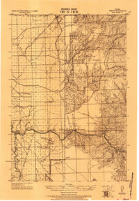
 1922 Custer1922 Print · USGSThe Salmon River high country comes alive in the years following the Great War, showing a landscape of isolated mining camps and early forest service outposts. Genealogists and researchers can trace the roads and trails connecting Custer, Bonanza, and the Sunbeam Mine.3 unique versions available
 - 1923 Map of Washington Creek
 1923 Washington Creek1923 Print · USGSThe Clearwater and Shoshone county line area in the early 1920s shows a frontier landscape of remote homesteads and forest reserves. Genealogists can locate named residents such as Fred Forsman and James Conner or the early buildings at Headquarters.
 - 1924 Map of Kamiah
 1924 Kamiah1924 Print · USGSNorth-central Idaho settlements thrive along the Clearwater River and upland plateaus during the mid-twenties. Genealogists and historians can trace the paths of the Northern Pacific railroad through rail towns like Volmer, Cottonwood, and the river crossing at Kamiah.
 - 1924 Map of Weippe
 1924 Weippe1924 Print · USGSNorth-central Idaho in the early 1920s is captured here, from the prairie settlements to the deep river canyons of the Clearwater. Genealogists can trace early homesteaders like G.W. Ford or locate long-gone post offices at Tahoe and Lowell.
 - 1924 Map of Hell Creek, 1958 Print
 1924 Hell Creek1958 Print · USGSSoutheast Idaho's high country is captured here during the mid-twenties, showcasing the rural life of Bonneville and Bingham Counties. Genealogists and local historians can trace family-named landmarks like Skelly Hill, the remote Dehlin School, and the early Hell Creek Ranger Station.2 unique versions available
 - 1924 Map of Ammon, 1958 Print
 1924 Ammon1958 Print · USGSSoutheast Idaho at the dawn of the motorized age shows a landscape of developing irrigation and rural schools. You can trace the path of the Union Pacific through Ammon or locate historic schoolhouses like Dewey School and Henry Creek School.3 unique versions available
 - 1926 Map of Hell Creek
 1926 Hell Creek1926 Print · USGSThe ranching and forest lands of eastern Idaho are captured here in the mid-1920s. Researchers can trace the rural infrastructure of the day, from the Dehlin School to the remote Fall Creek Ranger Sta and the waters of Tex Creek.2 unique versions available
 - 1929 Map of Bayhorse, 1961 Print
 1929 Bayhorse1961 Print · USGSCentral Idaho mining and ranching life are detailed in the late 1920s as mountain settlements like Bayhorse and Clayton thrived. Researchers can trace historic extraction sites like the Hecla Mine and Redbird Mine or locate the old East Fork Sch.
End of results
Showing maps 1-10 of 10
Top cities of Idaho
- Boise historical maps
- Meridian historical maps
- Nampa historical maps
- Idaho Falls historical maps
- Caldwell historical maps
- Pocatello historical maps
See more
Top counties of Idaho
- Ada County historical maps
- Canyon County historical maps
- Kootenai County historical maps
- Bonneville County historical maps
- Bannock County historical maps
- Twin Falls County historical maps
See more
Frequently asked questions
- What are the different types of historical maps available for Idaho?
- What is the oldest map of Idaho?
- Where can I purchase historical maps of Idaho for my home or office?
- Where can I download high-res historical maps of Idaho?
- Are there historical topographic maps available for Idaho?
- Is there historical aerial imagery available for Idaho?
- Where are historical maps of Idaho sourced from?