1950s Maps of Indiana
Explore 496 historic maps of Indiana from the 1950s. These maps offer a rare glimpse into what life looked like during the 1950s — showing old roads, neighborhoods, homes, and landmarks that have changed or disappeared over time.
Whether you're researching your family's past, planning a metal detecting trip, or studying how Indiana's landscape evolved across the 1950s, these high-resolution maps are a powerful tool for exploring the history of this region.
- Focus on a specific era: All maps on this page are from the 1950s, giving you a focused view of this time period.
- See what’s changed: Compare century-old streets, trails, and buildings to today's modern landscape using overlays and satellite layers.
- Research with precision: Use these maps for genealogy, historical research, land use analysis, or educational projects.
- View, download, or print: Maps are fully viewable online in high resolution, and can be downloaded or printed for your own records.
Start exploring Indiana's history through authentic maps from the 1950s. This is your window into the past.
Indiana maps
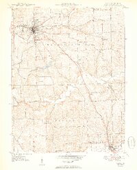
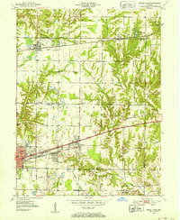
(496)- 1950 Map of Paducah
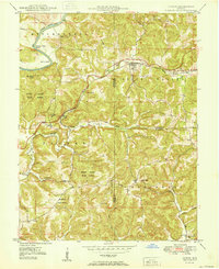
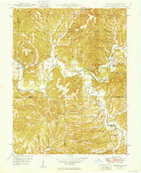
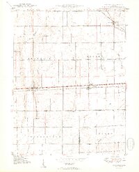
 1950 Paducah1950 Print · USGSThe confluence of the great midwestern rivers defines this mid-century landscape at the intersection of Illinois, Kentucky, and Missouri. Genealogists and historians can trace the rail-and-river economy through the hubs of Paducah, Cairo, and Metropolis or locate family roots near the Wildcat Hills.
 - 1950 Map of Salem
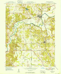
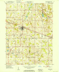
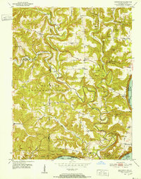
 1950 Salem1950 Print · USGSWashington County at mid-century centers on the industrious town of Salem and the winding Blue River valley. Family historians can trace rural roots at Old Blue River Cem, Canton, and the Pierce Consolidated Sch along the Monon rail line.2 unique versions available
 - 1950 Map of Gosport
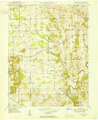
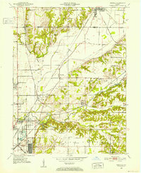
 1950 Gosport1950 Print · USGSMid-century Owen and Monroe Counties center on the winding river valley as the regional rail network and park system flourished. Researchers can trace rural lineages through sites like Old Dutch Ch, Stinesville, and the Chambersville Cem.
 - 1950 Map of Becks Mill
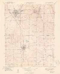
 1950 Becks Mill1950 Print · USGSWashington County at the start of the 1950s shows a landscape of small farming townships and vital rail connections. Researchers can locate family roots at Becks Mill, trace the path of the Chicago Indianapolis and Louisville railroad, or find rural landmarks like Mount Tabor Ch and Texas Sch.
 - 1950 Map of Mitchell
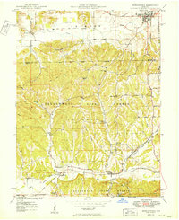
 1950 Mitchell1950 Print · USGSMitchell and Orleans sit at a critical railroad junction in southern Indiana during the mid-twentieth century. Researchers can trace the karst landscape of Spring Mill State Park or locate family roots near Liberty Ch and Lawrenceport Cem.2 unique versions available
 - 1950 Map of Arney
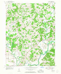 1950 Arney1950 Print · USGSMid-century Owen County life centered on the river junctions and rural townships. Trace the paths of the New York Central railroad and find historic river landmarks like Farmers Ferry and small settlements like Point Commerce.2 unique versions available
 - 1950 Map of New Castle East
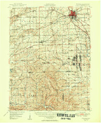
 1950 New Castle East1950 Print · USGSMid-century Henry County centers on the industrial growth of New Castle and the unique institutional landscape of the Indiana Village for Epileptics. Genealogists can trace family landmarks like South Mound Cem, Batson Ch, and several rural schoolhouses.2 unique versions available
 - 1950 Map of Fort Knox
 1950 Fort Knox1950 Print · USGSFort Knox and its surroundings in the years following the war show a landscape transformed by military necessity and river valley geography. Researchers can trace the layout of the US Bullion Depository and Godman Field alongside older communities like West Point and Goldville.
 - 1950 Map of Belmont
 1950 Belmont1950 Print · USGSThe Brown County hill country in 1950 shows a landscape of ridge-top roads and secluded valley settlements. Genealogists can trace family names at the T C Steele Memorial, Duncan Ch, and Brummet Cem among the deep hollows.
 - 1950 Map of Huron
 1950 Huron1950 Print · USGSSouthern Indiana's timbered hills and rail corridors are captured here in the mid-twentieth century. Genealogists and hikers can trace the Baltimore and Ohio line past Willow Tunnel or find the remote Acre Cem and Wiesbach Sch.
 - 1950 Map of Shoals
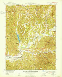
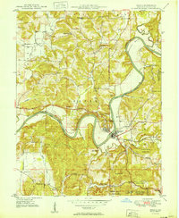 1950 Shoals1950 Print · USGSMartin County’s river-carved landscape is captured here in the mid-twentieth century, centered on the horseshoe bend of the East Fork White River. Genealogists can trace family footprints at Mt Union Ch, Poplar Grove Ch, and schools like Hickory Ridge Sch or Red Sch.2 unique versions available
 - 1950 Map of Morgantown
 1950 Morgantown1950 Print · USGSMid-century Morgan and Brown Counties are shown here at a time when the Illinois Central railroad still linked small rural timber and farming hamlets. Trace family roots and vanished landmarks near Helmsburg, Needmore, and the Bear Creek Cem.2 unique versions available
 - 1950 Map of Franklin
 1950 Franklin1950 Print · USGSMid-century Johnson County and Brown County come into focus here, showing the expansion of settlements and military infrastructure during the post-war years. Researchers can trace the layout of the Camp Atterbury Military Reservation, locate family names at Greenlawn Cemetery, or find vanished landmarks like the Prisoner of War Camp.2 unique versions available
 - 1950 Map of Edinburg
 1950 Edinburg1950 Print · USGSMid-century Shelby and Bartholomew Counties are captured here as the military presence at Atterbury meets a deeply rooted farming landscape. Researchers can locate dozens of country landmarks like Jollity Church, Tennehill Bridge, and the Shelby Township School.2 unique versions available
 - 1950 Map of Elkinsville
 1950 Elkinsville1950 Print · USGSBrown County's rugged ridge-and-hollow terrain is captured here at mid-century, just as the local forest preserves were maturing. Genealogists and hikers can trace old family sites like Elkinsville Cem, Maumee Sch, and the Hickory Ridge Lookout Tower.
 - 1950 Map of Laconia
 1950 Laconia1950 Print · USGSHarrison County settlement patterns are preserved here in the mid-twentieth century, centered on the riverfront and the rural crossroads of Laconia. Researchers can trace dozens of family cemeteries like Ferree Cem and vanished landmarks like Rehoboth Sch or Tobacco Landing.2 unique versions available
 - 1950 Map of Palmyra
 1950 Palmyra1950 Print · USGSMid-century Harrison and Washington counties are documented here at a time when small rural settlements like Martinsburg and Palmyra anchored the local landscape. Genealogists can trace family footprints through sites like Snyders Chapel, Miller Cem, and the Morgan Township Sch.2 unique versions available
 - 1950 Map of Dunreith
 1950 Dunreith1950 Print · USGSSouthern Henry County in the mid-twentieth century reveals a landscape defined by the intersection of major rail lines and rural townships. Researchers can trace family history through several local burial sites like Shiloh Cem or locate the industrial works at Stone Quarry Mills.
 - 1950 Map of Lewisville
 1950 Lewisville1950 Print · USGSEast-central Indiana farmland is documented here in the mid-twentieth century, centered on the railroad corridor through Lewisville. Genealogists can trace family roots through rural landmarks like Rich Square Ch, Ebenezer Ch, and the small settlement of Beacon.2 unique versions available
 - 1950 Map of Leesburg, 1952 Print
 1950 Leesburg1952 Print · USGSKosciusko County at the start of the fifties shows a lakefront landscape evolving through rail and air travel. Trace family roots at New Salem or Dutchtown, and explore the shoreline landings at Big Chapman Lake and the grounds of the Tippecanoe Country Club.2 unique versions available
 - 1950 Map of Pierceton, 1952 Print
 1950 Pierceton1952 Print · USGSIndiana's farm country and glacial lake districts are captured here in the early fifties, centered on the railroad town of Pierceton. Trace family roots at Washington-Union Cemetery, locate the Consolidated School, or explore the shores of Robinson and Sellers Lake.2 unique versions available
 - 1950 Map of Rosedale, 1952 Print
 1950 Rosedale1952 Print · USGSThe rail-and-creek landscape of Parke and Vigo counties comes alive in this mid-century survey. Trace family roots and vanished rail stops through settlements like Atherton, Sandcut, and Burnett, or locate country landmarks like Friendship Ch and Markles Cem.2 unique versions available
 - 1950 Map of Charlestown, 1952 Print
 1950 Charlestown1952 Print · USGSSouthern Indiana was undergoing a major industrial and military transformation at mid-century as the Cold War intensified. Local researchers can trace the massive Indiana Arsenal, the path of the Pennsylvania RR, and family history at St Michael Ch or Pleasant Grove Cem.
 - 1950 Map of Brazil East, 1952 Print
 1950 Brazil East1952 Print · USGSClay County at mid-century was a landscape defined by coal and transit, as massive industrial earthworks reshaped the outskirts of its communities. Genealogists and historians can trace the foundations of Brazil and Knightsville or locate rural landmarks like Wesley Chapel and Calcutta Cem.
 - 1950 Map of Beechwood, 1952 Print
 1950 Beechwood1952 Print · USGSThe Indiana-Kentucky borderlands along the Ohio River appear in high detail during the early fifties. Genealogists and hikers can trace remote landmarks like the Buzzard Roost Fire Tower, Old Union Ch, and the Wiseman Cem.3 unique versions available
Showing maps 1-25 of 496
Top cities of Indiana
- Indianapolis historical maps
- Fort Wayne historical maps
- Evansville historical maps
- South Bend historical maps
- Carmel historical maps
- Fishers historical maps
See more
Top counties of Indiana
- Lake County historical maps
- Allen County historical maps
- Hamilton County historical maps
- Saint Joseph County historical maps
- Elkhart County historical maps
- Tippecanoe County historical maps
See more
Frequently asked questions
- What are the different types of historical maps available for Indiana?
- What is the oldest map of Indiana?
- Where can I purchase historical maps of Indiana for my home or office?
- Where can I download high-res historical maps of Indiana?
- Are there historical topographic maps available for Indiana?
- Is there historical aerial imagery available for Indiana?
- Where are historical maps of Indiana sourced from?