1920s Maps of Iowa
Explore 17 historic maps of Iowa from the 1920s. These maps offer a rare glimpse into what life looked like during the 1920s — showing old roads, neighborhoods, homes, and landmarks that have changed or disappeared over time.
Whether you're researching your family's past, planning a metal detecting trip, or studying how Iowa's landscape evolved across the 1920s, these high-resolution maps are a powerful tool for exploring the history of this region.
- Focus on a specific era: All maps on this page are from the 1920s, giving you a focused view of this time period.
- See what’s changed: Compare century-old streets, trails, and buildings to today's modern landscape using overlays and satellite layers.
- Research with precision: Use these maps for genealogy, historical research, land use analysis, or educational projects.
- View, download, or print: Maps are fully viewable online in high resolution, and can be downloaded or printed for your own records.
Start exploring Iowa's history through authentic maps from the 1920s. This is your window into the past.
Iowa maps
- 1923 Map of Lehigh
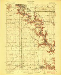 1923 Lehigh1923 Print · USGSWebster County in the early twenties centers on the industrial and mining hubs along the Des Moines River. Trace the history of regional industries through Clayworks, Coalville, and Kalo, or locate rural landmarks like Coon Mound and Wildcat Cave.3 unique versions available
 - 1923 Map of Fort Dodge
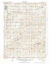
 1923 Fort Dodge1923 Print · USGSThe river valleys and rail corridors of North Central Iowa are detailed here in the years following the Great War. Genealogists and local historians can locate dozens of rural schoolhouses and the early footprints of Humboldt, Badger, and Fort Dodge.3 unique versions available
 - 1924 Map of Melcher
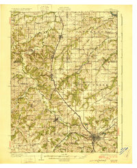
 1924 Melcher1924 Print · USGSSouth-central Iowa thrives during the 1920s coal boom, where rail lines and mine shafts transformed the rural landscape. Trace the growth of mining towns like Tipperary and Bucknell, and locate vanished local schools such as Coal Glen School.3 unique versions available
 - 1926 Map of Stoddard
 1926 Stoddard1926 Print · USGSUpper Mississippi river life and ridge-top farming meet in the mid-1920s along the Wisconsin-Minnesota border. Researchers can trace the complex river channels near Stoddard or find family roots at rural landmarks like Evening Star School and Romance.2 unique versions available
 - 1929 Map of Albia
 1929 Albia1929 Print · USGSMonroe County was a bustling coal and rail corridor during the late twenties, anchored by the junction at Albia. Genealogists and historians can trace defunct mining camps like Hiteman and dozens of rural school sites such as Halfway Prairie Sch.3 unique versions available
 - 1929 Map of Ferryville, 1957 Print
 1929 Ferryville1957 Print · USGSThe riverfront and ridge-top communities of Crawford and Vernon counties are captured here in the late 1920s before major lock and dam construction. Genealogists can locate family landmarks such as Freeman Church, Redmound School, and the riverside tracks of the Chicago Burlington and Quincy Railroad.2 unique versions available
 - 1929 Map of Prairie Du Chien, 1963 Print
 1929 Prairie Du Chien1963 Print · USGSThe Mississippi River valley of Crawford County at the end of the twenties shows a landscape of complex sloughs and rugged ridges. Genealogists can locate family schoolhouses like Frenchtown Sch and Hazen Corners Sch or trace the early rail lines through Prairie du Chien.
End of results
Showing maps 1-7
Top cities of Iowa
- Des Moines historical maps
- Cedar Rapids historical maps
- Davenport historical maps
- Sioux City historical maps
- Iowa City historical maps
- West Des Moines historical maps
See more
Top counties of Iowa
- Polk County historical maps
- Linn County historical maps
- Scott County historical maps
- Johnson County historical maps
- Black Hawk County historical maps
- Woodbury County historical maps
See more
Frequently asked questions
- What are the different types of historical maps available for Iowa?
- What is the oldest map of Iowa?
- Where can I purchase historical maps of Iowa for my home or office?
- Where can I download high-res historical maps of Iowa?
- Are there historical topographic maps available for Iowa?
- Is there historical aerial imagery available for Iowa?
- Where are historical maps of Iowa sourced from?