1930s Maps of Iowa
Explore 24 historic maps of Iowa from the 1930s. These maps offer a rare glimpse into what life looked like during the 1930s — showing old roads, neighborhoods, homes, and landmarks that have changed or disappeared over time.
Whether you're researching your family's past, planning a metal detecting trip, or studying how Iowa's landscape evolved across the 1930s, these high-resolution maps are a powerful tool for exploring the history of this region.
- Focus on a specific era: All maps on this page are from the 1930s, giving you a focused view of this time period.
- See what’s changed: Compare century-old streets, trails, and buildings to today's modern landscape using overlays and satellite layers.
- Research with precision: Use these maps for genealogy, historical research, land use analysis, or educational projects.
- View, download, or print: Maps are fully viewable online in high resolution, and can be downloaded or printed for your own records.
Start exploring Iowa's history through authentic maps from the 1930s. This is your window into the past.
Iowa maps
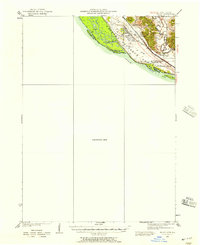
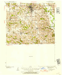
(24)- 1930 Map of Mitchellville
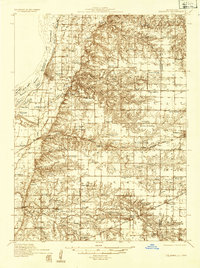
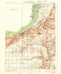
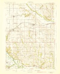 1930 Mitchellville1930 Print · USGSCentral Iowa's fertile prairie and river valleys come alive in this late 1920s survey of the settlements between the Skunk and Des Moines rivers. Researchers can locate dozens of country schools like Nebo Sch and Peacock Sch or trace family roots near Camp Center Ch.3 unique versions available
 - 1931 Map of Indianola
 1931 Indianola1931 Print · USGSWarren County at the end of the 1920s reveals a landscape of thriving rail junctions and rural schoolhouses across central Iowa. Researchers can trace the path of the Chicago Great Western RR through Martensdale and locate local landmarks like Scotch Ridge Sch and the Orillia Mine.4 unique versions available
 - 1932 Map of Ferryville
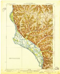 1932 Ferryville1932 Print · USGSThe Mississippi River bottoms and the ridge-and-hollow country of western Wisconsin are captured here in the early 1930s. Genealogists can trace family farm locations near dozens of rural landmarks like Redmound School, Freeman Church, and Battle Slough.
 - 1932 Map of Prairie Du Chien
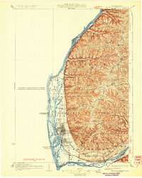 1932 Prairie Du Chien1932 Print · USGSCrawford County at the confluence of the two great rivers in the early thirties shows a landscape of ridge-top schools and bustling riverfront rail towns. Genealogists can trace family footprints at Wrights Ferry, Hazen Corners, or rural outposts like Lamer Ridge Sch.4 unique versions available
 - 1932 Map of Lomax, 1957 Print
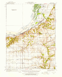 1932 Lomax1957 Print · USGSWestern Illinois river towns and railroad junctions thrive during the early 1930s as the river remains a central artery for commerce and life. Genealogists can trace family footprints across dozens of rural landmarks, including Dallas City, Gittings Mound, and the uniquely named Froggie Sch.
 - 1934 Map of Oquawka
 1934 Oquawka1934 Print · USGSHenderson County river life and prairie farming are captured here in the mid-thirties, from the Mississippi sloughs to the railroad towns. Genealogists can locate family landmarks including the County Farm, Coghill Cem, and the Little Brick Sch.3 unique versions available
 - 1934 Map of Humeston
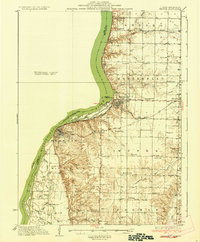
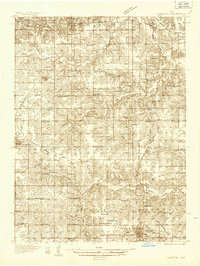 1934 Humeston1934 Print · USGSSouthern Iowa farmland and small-town commerce define this 1930s landscape, where rail lines and river branches meet. Genealogists can trace family roots at Humeston and Corydon or locate rural landmarks like Eden Ch and the Wayne County Farm.3 unique versions available
 - 1934 Map of Burlington
 1934 Burlington1934 Print · USGSThe river bottomlands of Illinois and Iowa come alive in the mid-1930s, showing a landscape defined by the shifting currents and rail lines. Genealogists and historians can trace small rural communities and local education centers like Orchard City, Carthage Junc, and Crystal Lake Sch.2 unique versions available
 - 1935 Map of Keithsburg
 1935 Keithsburg1935 Print · USGSMercer County during the mid-thirties reveals a landscape of river towns and railroad junctions along the Mississippi. Genealogists and local historians can trace rural roots at Peniel Ch, Brick Cem, and numerous schoolhouses like Hazel Dell Sch.4 unique versions available
 - 1935 Map of Nehawka
 1935 Nehawka1935 Print · USGSThe Missouri River valley along the Nebraska-Iowa border appears here during the mid-1930s, showing a landscape defined by riverside bluffs and fertile bottomlands. Genealogists can trace family roots through numerous local landmarks, from Sargents Spur and Nehawka to rural schools like Ameck Sch and Eight Mile Grove Sch.2 unique versions available
 - 1935 Map of East Dubuque, 1957 Print
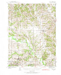
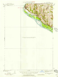 1935 East Dubuque1957 Print · USGSThe riverfront and rail lines of Jo Daviess County come alive in this mid-1930s survey of the tri-state border region. Researchers can trace the old tracks of the Chicago Illinois Burlington and Quincy and locate vanished rural schoolhouses like Miller Sch and Sand Ridge Sch.
 - 1935 Map of Miles, 1957 Print
 1935 Miles1957 Print · USGSIn the mid-1930s, the Mississippi River shoreline was defined by military expansion and the rail economy. Genealogists and historians can trace the foundations of the Savanna Ordnance Depot and local landmarks like Whitton and Lost Mound Sch.
 - 1935 Map of Russell, 1958 Print
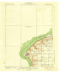
 1935 Russell1958 Print · USGSSouthern Iowa in the mid-thirties was a landscape of river-valley farms and rail-connected towns like Russell and Melrose. Researchers can trace old township school locations such as Brush College Sch and Rabbit Hill Sch or locate the New York Cem.2 unique versions available
 - 1936 Map of Keokuk
 1936 Keokuk1936 Print · USGSHancock County and the Mississippi River transition into a new era of hydroelectric power and rail transit in the 1930s. Genealogists can locate dozens of country schools and churches, from Froggy Sch and Sylvanvale Sch to Sanobia Ch.3 unique versions available
 - 1936 Map of Fort Madison
 1936 Fort Madison1936 Print · USGSThe Illinois shore of the Mississippi River is captured here in the mid-1930s, featuring the historic street grid of Nauvoo. Genealogists and local historians can trace a dense network of rural landmarks, including Jackson Cem and numerous country schoolhouses like Maple Grove Sch and Elliott Sch.3 unique versions available
 - 1937 Map of Corydon
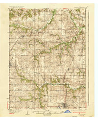 1937 Corydon1937 Print · USGSWayne County and the city of Corydon are captured in the mid-1930s, showing a landscape tightly organized around rail transport and rural education. Genealogists and historians can trace dozens of country schools and churches like Rabbit Ridge Sch, Brown Jug Sch, and Eden Ch.2 unique versions available
 - 1937 Map of Lomax
 1937 Lomax1937 Print · USGSThe riverfront and rail corridors of Henderson and Hancock Counties come alive in the late 1930s, documenting a time of active country schools and river commerce. Genealogists can locate family landmarks like Gittings Cem, Enterprise Ch, and distinctively named sites like Shake Rag Sch.2 unique versions available
 - 1938 Map of Iowa City
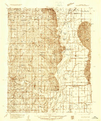
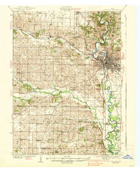 1938 Iowa City1938 Print · USGSIowa City and its surrounding townships are captured in the mid-1930s, revealing a landscape of rural schoolhouses and the early University of Iowa campus. Trace vanished local landmarks like the State Sanatorium, Iowa City Landing Field, and dozens of named country schools.3 unique versions available
 - 1938 Map of Russell
 1938 Russell1938 Print · USGSSouthern Iowa's rural school and rail network are preserved here during the mid-1930s. Genealogists can trace family footprints across dozens of local landmarks like Hilledgeville Cem, Rabbit Hill Sch, and the settlement of Confidence.2 unique versions available
 - 1938 Map of Edgington, 1955 Print
 1938 Edgington1955 Print · USGSThe Mississippi River corridor in the late thirties shows a landscape of active rail lines and riverfront industry. Genealogists can trace rural family roots through numerous local landmarks like Jimtown, White Eagle School, and Buffalo Center School.
 - 1939 Map of Farragut
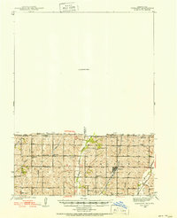 1939 Farragut1939 Print · USGSThe Iowa-Missouri borderlands come into focus in the late 1930s, showing a landscape of river-valley farms and rural schoolhouses. Genealogists can trace family roots through sites like Walden Grove Cem, Yale Sch, and the community at Westboro.
 - 1939 Map of Hamburg
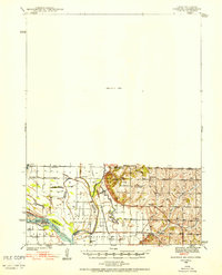 1939 Hamburg1939 Print · USGSThe Missouri River lowlands at the triple-state border are captured here just before the mid-century. Genealogists can trace family footprints across a dense network of rural schoolhouses like Miller Sch and Star Sch, or locate the Stoner Cem and Lone Chapel.2 unique versions available
 - 1939 Map of Centerville, 1954 Print
 1939 Centerville1954 Print · USGSAppanoose County sits at a busy rail crossroads in the late thirties, just as the regional landscape was transitioning toward modern infrastructure. Genealogists can trace family footprints across dozens of rural landmarks like Cornbread College Sch, Jewish Cem, and Cincinnati.3 unique versions available
 - 1939 Map of Mystic, 1966 Print
 1939 Mystic1966 Print · USGSAppanoose County in the late thirties is a landscape of thriving rural townships and busy rail junctions. Genealogists and historians can trace family roots through numerous country schools like Buffalo Wallow Sch and churches such as Wesley Chapel.
End of results
Showing maps 1-24 of 24
Top cities of Iowa
- Des Moines historical maps
- Cedar Rapids historical maps
- Davenport historical maps
- Sioux City historical maps
- Iowa City historical maps
- West Des Moines historical maps
See more
Top counties of Iowa
- Polk County historical maps
- Linn County historical maps
- Scott County historical maps
- Johnson County historical maps
- Black Hawk County historical maps
- Woodbury County historical maps
See more
Frequently asked questions
- What are the different types of historical maps available for Iowa?
- What is the oldest map of Iowa?
- Where can I purchase historical maps of Iowa for my home or office?
- Where can I download high-res historical maps of Iowa?
- Are there historical topographic maps available for Iowa?
- Is there historical aerial imagery available for Iowa?
- Where are historical maps of Iowa sourced from?