Old Maps of Iowa for Academic Research
Study the evolution of Iowa with 2,595 high-resolution historic maps. Whether you're teaching, researching, or modeling changes in land use, these maps provide essential visual documentation of urban, environmental, and geographic change.
- Analyze long-term change: Track patterns in development, transportation, and natural features.
- Ideal for environmental or urban studies: Support academic projects with primary historical map data.
- Use in the classroom or lab: Educators and researchers rely on these maps to bring historical context to life.
These maps are a powerful tool for teaching, research, and visualizing how Iowa has changed over the decades.
Iowa maps
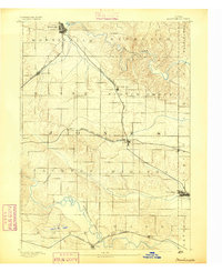
(2,595)- 1887 Map of Cedar Rapids
 1887 Cedar Rapids1887 Print · USGSLinn and Johnson Counties come alive in this late 19th-century study of the river valleys and rail lines connecting Cedar Rapids to the surrounding prairie. Genealogists can trace old property lines across Jefferson and Big Grove or locate early settlements like Ely and Shueyville.
 - 1888 Map of Shellsburg
 1888 Shellsburg1888 Print · USGSBenton and Linn Counties come alive in this late nineteenth-century survey of the eastern Iowa heartland. Local historians can trace the early rail-side growth of Shellsburg and Palo or follow the winding Cedar River past Opossum Creek and Urbana.
 - 1888 Map of Marion
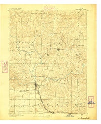
 1888 Marion1888 Print · USGSLinn County thrives as a late 19th-century rail center where major lines intersect at the growing town of Marion. Genealogists and historians can trace the early township divisions and steam-era routes like the Illinois Central Railroad and Central City.
 - 1888 Map of Amana
 1888 Amana1888 Print · USGSThe Amana Colonies and the Iowa River valley are shown here in the late 1880s, during a period of communal prosperity and rail expansion. Genealogists can trace the specific villages of Hohe Amana, Middle Amana, and Homestead alongside three major railroads.
 - 1889 Map of Tipton
 1889 Tipton1889 Print · USGSCedar County at the close of the nineteenth century was a landscape shaped by two major rail lines. Genealogists and local historians can trace the early town plats of Tipton, Mechanicsville, and Stanwood, alongside landmarks like Sugar Creek and the Chicago and North-Western Railroad.
 - 1889 Map of Marion
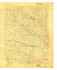
 1889 Marion1889 Print · USGSMarion and the surrounding townships in the 1880s show a landscape transformed by the iron horse and river trade. Genealogists can trace the early rail-connected footprints of Marion, Central City, and Toddville along the Illinois Central Railroad.3 unique versions available
 - 1889 Map of Amana
 1889 Amana1889 Print · USGSCentral Iowa at the close of the nineteenth century reveals the unique communal settlement of the Amana colonies along the Iowa River. Trace early village footprints from Hohe Amana to Homestead and the rail corridors of the Chicago and Northwestern Railroad.2 unique versions available
 - 1889 Map of Shellsburg
 1889 Shellsburg1889 Print · USGSBenton and Linn Counties come alive in the late 1880s as the rail-driven economy begins to reshape the Iowa prairie. Researchers can trace the early development of Shellsburg and Center Point along the Burlington Cedar Rapids and Northern Railroad.
 - 1890 Map of Durant
 1890 Durant1890 Print · USGSEastern Iowa's rail-dependent farming communities are documented in the late nineteenth century as the grid of townships began to mature. Genealogists and historians can trace the early footprints of Durant, Walcott, and the remote Round Grove P.O. along established rail lines.
 - 1890 Map of Tipton
 1890 Tipton1890 Print · USGSCedar County in the late nineteenth century is captured here as a thriving rail-centered landscape. Genealogists and local historians can trace the early grids of Tipton, Mechanicsville, and Stanwood along the tracks of the Chicago and North-Western Railroad.2 unique versions available
 - 1890 Map of Anamosa
 1890 Anamosa1890 Print · USGSEastern Iowa was a landscape defined by river valleys and expanding rail lines in the 1890s. Genealogists can trace family roots through early settlements like Anamosa, Springville, and Viola along the Chicago Milwaukee and St. Paul Railroad.2 unique versions available
 - 1891 Map of DeWitt
 1891 DeWitt1891 Print · USGSClinton County is shown here during the peak of its railroad expansion in the late nineteenth century. Researchers can trace the development of De Witt and find early platted details for Delmar, Elwood, and the junction at Grand Mound.3 unique versions available
 - 1891 Map of Davenport
 1891 Davenport1891 Print · USGSIowa's riverfront and rolling prairie townships are captured here during a period of rapid railroad expansion in the late nineteenth century. Trace early land tracts and rail junctions like Eldridge Junction or locate landmarks such as Green Tree Tavern and Maysville.
 - 1891 Map of Monticello
 1891 Monticello1891 Print · USGSJones County at the peak of the rail era shows a landscape organized by iron rails and river bends. Trace the junctions and early plats of Monticello, Center Junction, and Wyoming along the Chicago and North Western Railroad.3 unique versions available
 - 1891 Map of Oxford
 1891 Oxford1891 Print · USGSEastern Iowa in the late nineteenth century was a landscape of burgeoning rail towns and fertile creek bottoms. Genealogists can trace the early township borders of Oxford and York while following the paths of the Chicago Rock Island and Pacific Railroad and Old Mans Creek.
 - 1891 Map of Mechanicsville
 1891 Mechanicsville1891 Print · USGSEastern Iowa during the late Victorian era is defined here by its emerging rail corridors and the winding path of the Cedar River. Genealogists can trace the early footprints of settlements like Mechanicsville, Mt. Vernon, and Solon before modern development.
 - 1891 Map of Cedar Rapids
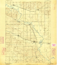
 1891 Cedar Rapids1891 Print · USGSEastern Iowa in the late nineteenth century is a landscape of growing river towns and expanding rail lines. Genealogists and historians can trace the early layout of Cedar Rapids and the development of rail hubs like Ely and Bertram along the Cedar River.2 unique versions available
 - 1891 Map of Maquoketa
 1891 Maquoketa1891 Print · USGSJackson County, Iowa, was a thriving agricultural and rail corridor in the years following the Civil War. Trace the early streets of Maquoketa and locate rural landmarks like Cottonville, Andrew, and the river crossing at Bridgeport.3 unique versions available
 - 1891 Map of Iowa City
 1891 Iowa City1891 Print · USGSIowa City and its surrounding townships appear at the peak of the late 19th-century rail era. Researchers can trace early railroad alignments like the Chicago Rock Island and Pacific and locate established settlements including Tiffin, Coralville, and South Liberty.3 unique versions available
 - 1891 Map of Wilton Junction
 1891 Wilton Junction1891 Print · USGSEastern Iowa in the late nineteenth century is defined here by the transit corridor of the Chicago Rock Island and Pacific Railroad. Genealogists and local historians can trace the early footprints of Wilton, Rochester, and the small industrial outpost at Lime City.3 unique versions available
 - 1891 Map of Baldwin
 1891 Baldwin1891 Print · USGSJackson County at the end of the century shows a rugged landscape transitioning from river-based industry to a railroad economy. Genealogists can trace family footprints in early settlements like Ozark, Clay Mills, and the rail hubs of Baldwin and Monmouth.3 unique versions available
 - 1891 Map of Clinton
 1891 Clinton1891 Print · USGSThe Mississippi River corridor thrived as a dual-state rail hub in the 1890s, anchored by the riverfront centers of Clinton and Fulton. Researchers can trace the early tracks of the Chicago and Northwestern RR and locate vanished stops like Almont and Argo.
 - 1892 Map of Wheatland
 1892 Wheatland1892 Print · USGSEastern Iowa in the late nineteenth century was a landscape of burgeoning rail towns and river settlements. Genealogists and historians can trace early property boundaries and rail corridors through Wheatland, the winding Wapsipinicon River, and the curiously named Lost Nation.
 - 1892 Map of Goose Lake
 1892 Goose Lake1892 Print · USGSClinton County thrived at the end of the nineteenth century as a hub of river commerce and expanding rail lines. Genealogists and local historians can trace the early development of Camanche on the Mississippi River or the inland rail stops of Charlotte and Low Moor.
 - 1892 Map of Savanna
 1892 Savanna1892 Print · USGSThe upper Mississippi corridor in the late nineteenth century was a bustling hub of river commerce and competing rail lines. Map enthusiasts can trace the old tracks of the Chicago Burlington and Northern Railroad and locate vanished landmarks like Hickory Grove or Idens Lake.8 unique versions available
Showing maps 1-25 of 2,595
Top cities of Iowa
- Des Moines historical maps
- Cedar Rapids historical maps
- Davenport historical maps
- Sioux City historical maps
- Iowa City historical maps
- West Des Moines historical maps
See more
Top counties of Iowa
- Polk County historical maps
- Linn County historical maps
- Scott County historical maps
- Johnson County historical maps
- Black Hawk County historical maps
- Woodbury County historical maps
See more
Frequently asked questions
- What are the different types of historical maps available for Iowa?
- What is the oldest map of Iowa?
- Where can I purchase historical maps of Iowa for my home or office?
- Where can I download high-res historical maps of Iowa?
- Are there historical topographic maps available for Iowa?
- Is there historical aerial imagery available for Iowa?
- Where are historical maps of Iowa sourced from?