1900s (20th Century) Maps of Missouri
Explore 2,547 historic maps of Missouri from the 1900s (20th Century). These maps offer a rare glimpse into what life looked like during the 1900s — showing old roads, neighborhoods, homes, and landmarks that have changed or disappeared over time.
Whether you're researching your family's past, planning a metal detecting trip, or studying how Missouri's landscape evolved across the 1900s, these high-resolution maps are a powerful tool for exploring the history of this region.
- Focus on a specific era: All maps on this page are from the 1900s, giving you a focused view of this time period.
- See what’s changed: Compare century-old streets, trails, and buildings to today's modern landscape using overlays and satellite layers.
- Research with precision: Use these maps for genealogy, historical research, land use analysis, or educational projects.
- View, download, or print: Maps are fully viewable online in high resolution, and can be downloaded or printed for your own records.
Start exploring Missouri's history through authentic maps from the 1900s. This is your window into the past.
Missouri maps
(2,547)- 1900 Map of Eureka Springs, 1954 Print
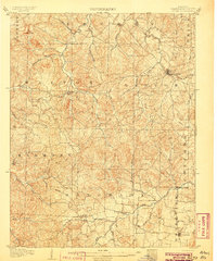
 1900 Eureka Springs1954 Print · USGSThe Ozark Mountains around the Arkansas and Missouri border are shown here during the turn of the century, when the river-and-rail economy was firmly established. Researchers can locate early family crossings and landmarks like Knox Ferry, Pivot Rock, and the St. Louis & San Francisco R. R.
 - 1901 Map of De Soto
 1901 De Soto1901 Print · USGSJefferson and Franklin Counties at the turn of the century show a landscape defined by industrial milling and river fords. Genealogists can trace early homesteads near Hillsboro or industrial sites like Vulcan Mine and Byrnes Mill.5 unique versions available
 - 1901 Map of Marshall
 1901 Marshall1901 Print · USGSCentral Missouri thrives along the river and rail lines at the turn of the century. Trace the early footprints of Marshall and Slater, or locate long-standing river landings and rural stations like Miami Station, Malta Bend, and Laynesville.5 unique versions available
 - 1901 Map of Eureka Springs
 1901 Eureka Springs1901 Print · USGSThe Arkansas Ozarks at the turn of the century are captured here in a time of river ferries and mountain townships. Genealogists and historians can locate early settlements like Eureka Springs and Berryville, or trace historic crossings such as Knox Ferry and Ellis Ford.3 unique versions available
 - 1901 Map of Fayetteville
 1901 Fayetteville1901 Print · USGSNorthwest Arkansas is seen here at the start of the twentieth century as railroads and trade began to reshape the Ozark foothills. Researchers can locate the Pea Ridge Battlefield and Elkhorn Tavern, or trace early industrial sites like Osage Mills and Rhea's Mill.4 unique versions available
 - 1903 Map of O'Fallon
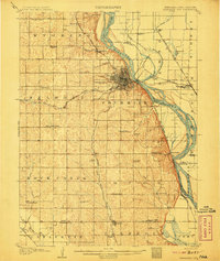
 1903 O'Fallon1903 Print · USGSSt. Charles County at the turn of the century is a labyrinth of river islands and rail lines at the confluence of the Missouri and Mississippi. Researchers can trace old river landings like Cap Au Gris Landing and family-named settlements from Moscow Mills to New Melle.5 unique versions available
 - 1903 Map of Yellville
 1903 Yellville1903 Print · USGSNorth Central Arkansas in the late nineteenth century is a land of winding river valleys and ridge-top settlements. Genealogists can trace early homesteads and river crossings like Denton Ferry, Yellville, and the remote outposts of Dodd City or St. Joe.
 - 1903 Map of Kahoka
 1903 Kahoka1903 Print · USGSNortheast Missouri at the turn of the century shows a landscape defined by the convergence of major rivers and competing rail lines. Genealogists can trace family roots in early centers like Kahoka and Monticello, or locate riverfront crossings at St. Francisville and Canton.3 unique versions available
 - 1903 Map of Sullivan
 1903 Sullivan1903 Print · USGSFranklin and Gasconade counties are captured here at the close of the nineteenth century, as the St. Louis and San Francisco railroad spurred growth in timber and mining. Genealogists can trace early homesteads and river crossings like Hughes Ford, Spring Bluff, and Anthonies Mill.3 unique versions available
 - 1903 Map of Palmyra
 1903 Palmyra1903 Print · USGSNortheast Missouri at the start of the twentieth century was a landscape of river-valley farming and critical rail junctions. Researchers can trace early rural life through features like Sharp Mills, St. Pauls Ch., and the crossing of the Hannibal and St. Joseph R. R.2 unique versions available
 - 1903 Map of Edina
 1903 Edina1903 Print · USGSNortheast Missouri at the turn of the century shows a bustling landscape of rail-fed market towns and river valley townships. Researchers can trace the path of the Santa Fe Railroad through Baring or locate early settlements like Pleasant Retreat and Bible Grove.2 unique versions available
 - 1903 Map of Siloam Springs, 1904 Print
 1903 Siloam Springs1904 Print · USGSThe border of Arkansas and the Cherokee Nation comes to life in this survey from the turn of the century. Genealogists and historians can trace the early layout of Siloam Springs or locate small landmarks like Shoaps Store and Round Spring Church.
 - 1904 Map of Siloam Springs
 1904 Siloam Springs1904 Print · USGSThe Arkansas and Indian Territory borderlands are captured here at the turn of the century, prior to Oklahoma statehood. Researchers can trace the early layout of Siloam Springs and locate vanished landmarks like Shoaps Store or the Round Spring Church.7 unique versions available
 - 1904 Map of Fayetteville
 1904 Fayetteville1904 Print · USGSNorthwest Arkansas was a land of emerging railroads and Civil War memory at the turn of the century. Genealogists can locate family homesteads near Rhea's Mill, the Pea Ridge Battlefield, and early river crossings like Vanwinkle Ferry.
 - 1904 Map of Eldon
 1904 Eldon1904 Print · USGSMiller and Morgan counties thrived at the turn of the century as the new railroad network connected agricultural hills to outside markets. Genealogists can trace family roots through early settlements like Barnett Sta. and Olean or locate the historic Simpson Coalmine.
 - 1904 Map of Gravois Mills
 1904 Gravois Mills1904 Print · USGSMorgan County is shown at a pivotal moment in the early twentieth century as railroads began to transform the local economy. Researchers can locate the historic rail junction at Versailles or trace early lead and zinc prospects like the Juliette Mine and Wolfoen Mine.2 unique versions available
 - 1904 Map of Harrison, 1954 Print
 1904 Harrison1954 Print · USGSThe Ozark Mountains of Northwest Arkansas are documented here at the turn of the century, showing a landscape of pioneer settlements and new rail lines. Genealogists can trace early homesteads and commerce at Blantons Mill, the village of Carrollton, and the regional hub of Harrison.
 - 1904 Map of Farmington, 1954 Print
 1904 Farmington1954 Print · USGSFarmington and the surrounding St. Francois County area are shown at a peak of early rail development at the turn of the century. Genealogists and historians can trace old wagon routes like Plank Road or locate vanished sites like Valley Forge and Thurman.2 unique versions available
 - 1905 Map of Harrison
 1905 Harrison1905 Print · USGSThe Ozark Plateau at the start of the century was a land of winding mountain railroads and isolated creek-side settlements. Genealogists can trace family footprints across the highlands from Lead Hill to Green Forest, finding early industrial landmarks like Blantons Mill and the Rock Quarry.3 unique versions available
 - 1905 Map of Yellville
 1905 Yellville1905 Print · USGSThe Ozark Mountains and the winding White River define this area at the start of the twentieth century. Genealogists can trace family names through dozens of river crossings and small settlements like Denton Ferry, Rush, and Elixir Springs.3 unique versions available
 - 1905 Map of Bonneterre
 1905 Bonneterre1905 Print · USGSEastern Missouri's Lead Belt comes into focus during its industrial peak at the turn of the century. Genealogists and rail historians can trace the intricate connections between Bonneterre, Desloge, and Bismarck along the Mississippi River and Bonneterre RR.3 unique versions available
 - 1906 Map of Potosi
 1906 Potosi1906 Print · USGSWashington County at the start of the century shows a landscape of Ozark creek bottoms and rail-connected towns. Genealogists and historians can trace old homesteads and landmarks near Potosi, Hunters Mill, and the community of Caledonia.3 unique versions available
 - 1906 Map of Farmington
 1906 Farmington1906 Print · USGSFarmington and the surrounding Ozark foothills are captured here during a pivotal era of railroad expansion and rural settlement. Genealogists and historians can trace defunct rail lines like the Illinois Southern Ry. and locate family landmarks in French Village or Valley Forge.2 unique versions available
 - 1907 Map of Nebraska City
 1907 Nebraska City1907 Print · USGSNebraska City and its surrounding Missouri River bluffs are captured here in the first decade of the 1900s during a period of significant rail expansion. Genealogists can locate numerous rural schoolhouses and small settlements like Minersville, Wyoming, and the historic St Lukes Church.3 unique versions available
 - 1907 Map of Forsyth
 1907 Forsyth1907 Print · USGSThe White River country of southwest Missouri is seen here in the early nineteen-hundreds, prior to the region's major dam projects. Genealogists can trace family homesteads near landmarks like Marble Cave, numerous riverside crossings such as Mabry Ferry, and local landmarks like Loafers Glory School.3 unique versions available
Showing maps 1-25 of 2,547
Top cities of Missouri
- Kansas City historical maps
- St. Louis historical maps
- Springfield historical maps
- Columbia historical maps
- Independence historical maps
- Lee's Summit historical maps
See more
Top counties of Missouri
- Saint Louis County historical maps
- Jackson County historical maps
- Saint Charles County historical maps
- St. Louis historical maps
- Greene County historical maps
- Clay County historical maps
See more
Frequently asked questions
- What are the different types of historical maps available for Missouri?
- What is the oldest map of Missouri?
- Where can I purchase historical maps of Missouri for my home or office?
- Where can I download high-res historical maps of Missouri?
- Are there historical topographic maps available for Missouri?
- Is there historical aerial imagery available for Missouri?
- Where are historical maps of Missouri sourced from?