1930s Maps of Missouri
Explore 208 historic maps of Missouri from the 1930s. These maps offer a rare glimpse into what life looked like during the 1930s — showing old roads, neighborhoods, homes, and landmarks that have changed or disappeared over time.
Whether you're researching your family's past, planning a metal detecting trip, or studying how Missouri's landscape evolved across the 1930s, these high-resolution maps are a powerful tool for exploring the history of this region.
- Focus on a specific era: All maps on this page are from the 1930s, giving you a focused view of this time period.
- See what’s changed: Compare century-old streets, trails, and buildings to today's modern landscape using overlays and satellite layers.
- Research with precision: Use these maps for genealogy, historical research, land use analysis, or educational projects.
- View, download, or print: Maps are fully viewable online in high resolution, and can be downloaded or printed for your own records.
Start exploring Missouri's history through authentic maps from the 1930s. This is your window into the past.
Missouri maps
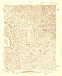
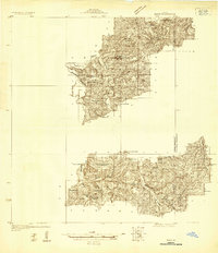
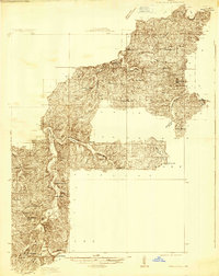
(208)- 1930 Map of Pearl
 1930 Pearl1930 Print · USGSThe Illinois River valley in the late 1920s shows a landscape of river-bottom farms and rugged bluff-top settlements. Genealogists can locate family landmarks like Miller Cem, Farmers Ridge Ch, and schools such as Summit Grove Sch or Village Green Sch.3 unique versions available
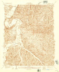
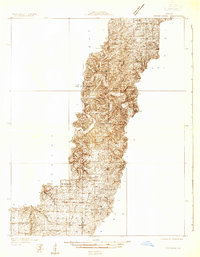
 - 1930 Map of De Soto NE
 1930 De Soto NE1930 Print · USGSJefferson County settlement and rural education are captured in the early 1930s as the railroad and river networks shaped the valley. Genealogists can locate family landmarks like Peter Moore Sch and Buckie Sch near the Victoria and De Soto corridors.
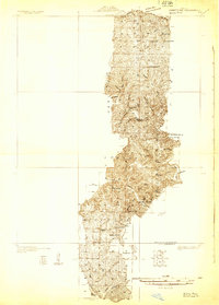
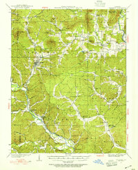
 - 1930 Map of Pacific SE
 1930 Pacific SE1930 Print · USGSJefferson County rural life in the early 1930s is captured here through its network of country schoolhouses and river valleys. Researchers can trace historic routes like Le May Ferry Road and find old settlements such as Belews and Goldman.2 unique versions available
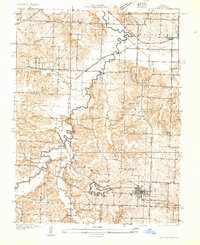
 - 1930 Map of Coldwater
 1930 Coldwater1930 Print · USGSMadison County's rugged river valleys and early Ozark settlements are documented here between the world wars. Genealogists can trace family roots at Revelle Cem, early river crossings like Wade Ford, and local centers like Coldwater or French Mills.4 unique versions available
 - 1930 Map of Nebo
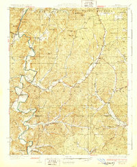
 1930 Nebo1930 Print · USGSThe Mississippi River bottomlands and Pike County bluffs are shown here in the late twenties, featuring a landscape of sloughs and rail-dependent towns. Trace family roots at Wildcat Cem or locate rural landmarks like Riprap Landing and Old Baptist Sch.
 - 1930 Map of Hardin
 1930 Hardin1930 Print · USGSCalhoun County's narrow peninsula is captured here between the two great rivers during the late Prohibition era. Genealogists and local researchers can locate numerous rural landmarks like Indian Creek Ch, Oases Ch, and a high concentration of schoolhouses including South Lincoln Sch.2 unique versions available
 - 1931 Map of Sikeston
 1931 Sikeston1931 Print · USGSSikeston and the surrounding Bootheel lowlands are captured here in the early 1930s as a massive drainage network transformed the landscape into fertile farmland. Researchers can trace the development of small rail towns like Morehouse and Canalou alongside old country schools like Stringer Sch and Hale Sch.2 unique versions available
 - 1931 Map of Barry
 1931 Barry1931 Print · USGSPike County bottomlands along the Mississippi River are shown here in the late twenties and early thirties, just as drainage projects transformed the landscape. Genealogists and local historians can trace rural school locations like Guss Sch and Munger Sch, or find family burials at Money Cem and Blackjack Cem.
 - 1931 Map of Fulton
 1931 Fulton1931 Print · USGSFulton and its rural Callaway County hinterlands are documented here in the early thirties as the region transitioned to modern highways. Genealogists can locate family-named landmarks like Scott Sch, Fairview Ch, and the settlement of Bachelor.2 unique versions available
 - 1931 Map of Manchester SE
 1931 Manchester SE1931 Print · USGSSt. Louis County and Jefferson County were still largely defined by the river and rail lines during the early 1930s. Researchers can trace the early layout of Times Beach or locate family-history landmarks like the Rankin Cem and Oak Ridge Sch.
 - 1931 Map of De Soto SE
 1931 De Soto SE1931 Print · USGSJefferson County was still a landscape of remote hill-country schools and river-valley railroads in the early thirties. Genealogists can trace family names and local landmarks like Mothershead Sch, the Joachim Cem, and the rail stop at Vineland.2 unique versions available
 - 1931 Map of Manes
 1931 Manes1931 Print · USGSWright and Texas Counties are shown here in the early thirties, a landscape of ridge-top schools and river-valley mills. Researchers can trace rural lineages through local landmarks like Grimes Mill, Post Oak Sch, and Evening Shade Ch.
 - 1931 Map of Pacific NE
 1931 Pacific NE1931 Print · USGSJefferson County was a land of river bends and rural schools in the early thirties. Local historians can trace the foundations of communities at Byrnes Mill and House Springs, or locate old schoolhouse sites like Whiteoak Sch and Cedar Sch.2 unique versions available
 - 1931 Map of Bandyville
 1931 Bandyville1931 Print · USGSThe Eleven Point River valley in the early 1930s remains a landscape of isolated rural townships and crossroads schools. Genealogists can trace family roots through sites like Falling Springs Cemetery, Hickory Grove Ch, and Bildad Sch.
 - 1931 Map of Brussels
 1931 Brussels1931 Print · USGSThe peninsula between the Illinois and Mississippi Rivers is captured here in the early 1930s, showcasing a network of river landings and ridge-top settlements. Genealogists can trace family roots through numerous local landmarks like Golden Eagle, Point Pleasant, and Nichols Sch.2 unique versions available
 - 1931 Map of Cairo, 1954 Print
 1931 Cairo1954 Print · USGSSouthern Illinois and western Kentucky meet at the great river confluence during the late 1920s and early 1930s. Genealogists can trace family footprints through numerous rural landmarks like Pleasant Hill Sch, the National Cem, and the riverfront at Mound City.2 unique versions available
 - 1932 Map of Manchester NE
 1932 Manchester NE1932 Print · USGSThe Missouri River floodplain and the rising bluffs of St. Louis County are captured here in the early 1930s. Genealogists and local historians can trace the foundations of Chesterfield and Bellefontaine alongside sites like Zion Sch and the St Louis City Water Works.
 - 1932 Map of Mexico
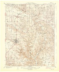
 1932 Mexico1932 Print · USGSThe rail hub of Mexico and the surrounding Audrain County farm country are captured here between the wars, just as modern highways began to parallel the older tracks. Genealogists can locate dozens of country schools and churches, from Hedgesdale Sch to Sunrise Ch, and the grounds of the Mo Military Academy.3 unique versions available
 - 1932 Map of Hannibal
 1932 Hannibal1932 Print · USGSAlong the Mississippi River in the early 1930s, this survey captures the riverfront from Hannibal across to the Illinois bottomlands. Researchers can trace the river rail crossings of the WABASH and locate rural landmarks like Bird Slough Sch and the CHENALE ECARTE CLUB.4 unique versions available
 - 1932 Map of Steelville
 1932 Steelville1932 Print · USGSCrawford County's river valleys and rail junctions are documented here during the early 1930s. Genealogists and historians can locate rural landmarks like Frazier Cem, the St Louis-San Francisco rail line, and numerous schools such as Liberty Sch.
 - 1932 Map of Versailles No 4
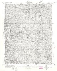
 1932 Versailles No 41932 Print · USGSThe Missouri Ozarks are captured here in the early 1930s, showing the early transformation of the landscape following the creation of Lake of the Ozarks. Researchers can trace the roots of Osage Beach or locate rural landmarks like Popplewell Cem and Watson Sch.
 - 1932 Map of Cedar Grove
 1932 Cedar Grove1932 Print · USGSShannon County and the surrounding Ozark highlands are captured in the early 1930s, showing a landscape of small timber-country settlements. Genealogists can trace family homesteads near Cedar Grove and several local schools like Black Valley Sch and Round Valley Sch.
 - 1932 Map of Piedmont, 1955 Print
 1932 Piedmont1955 Print · USGSThe Ozark foothills come to life in the early 1930s, showing a landscape defined by the Black Missouri River and the railroad. Genealogists can trace family roots through numerous rural landmarks like Hog Eye Sch, Dees Chapel, and the community of Patterson.2 unique versions available
 - 1933 Map of Creve Coeur
 1933 Creve Coeur1933 Print · USGSSt. Louis County in the early thirties shows a landscape of growing suburbs and deep-rooted cemeteries. Trace family history at Fee Fee Cemetery and locate old landmarks like Chaminade College or the Zion Sch.
 - 1933 Map of Blue Springs
 1933 Blue Springs1933 Print · USGSJackson County in the 1930s shows a landscape of rural schoolhouses and family farms connected by the Little Blue River. Researchers can trace ancestral property near Lobb Cemetery or locate vanished landmarks like Selsa and the Old Blue Springs Sch.
Showing maps 1-25 of 208
Top cities of Missouri
- Kansas City historical maps
- St. Louis historical maps
- Springfield historical maps
- Columbia historical maps
- Independence historical maps
- Lee's Summit historical maps
See more
Top counties of Missouri
- Saint Louis County historical maps
- Jackson County historical maps
- Saint Charles County historical maps
- St. Louis historical maps
- Greene County historical maps
- Clay County historical maps
See more
Frequently asked questions
- What are the different types of historical maps available for Missouri?
- What is the oldest map of Missouri?
- Where can I purchase historical maps of Missouri for my home or office?
- Where can I download high-res historical maps of Missouri?
- Are there historical topographic maps available for Missouri?
- Is there historical aerial imagery available for Missouri?
- Where are historical maps of Missouri sourced from?