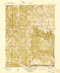
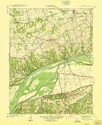
1940s Maps of Missouri
Explore 362 historic maps of Missouri from the 1940s. These maps offer a rare glimpse into what life looked like during the 1940s — showing old roads, neighborhoods, homes, and landmarks that have changed or disappeared over time.
Whether you're researching your family's past, planning a metal detecting trip, or studying how Missouri's landscape evolved across the 1940s, these high-resolution maps are a powerful tool for exploring the history of this region.
- Focus on a specific era: All maps on this page are from the 1940s, giving you a focused view of this time period.
- See what’s changed: Compare century-old streets, trails, and buildings to today's modern landscape using overlays and satellite layers.
- Research with precision: Use these maps for genealogy, historical research, land use analysis, or educational projects.
- View, download, or print: Maps are fully viewable online in high resolution, and can be downloaded or printed for your own records.
Start exploring Missouri's history through authentic maps from the 1940s. This is your window into the past.
Missouri maps
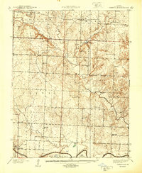
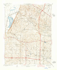
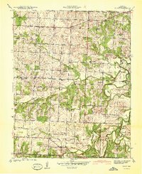
(362)- 1940 Map of Gainesville
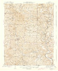 1940 Gainesville1940 Print · USGSOzark County at the end of the 1930s reveals a landscape of isolated river fords and high-ridge settlements. Genealogists and historians can trace family locations near landmarks like Gainesville, Price Cem, and White Ferry.2 unique versions available
 - 1940 Map of Tarkio
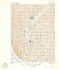 1940 Tarkio1940 Print · USGSAtchison County at the end of the Depression was a landscape of river-bottom farms and rural school districts. Genealogists can locate family-named landmarks and country parishes like English Grove Ch, Tarkio College, and Prairie Hill Cem.
 - 1940 Map of Farragut
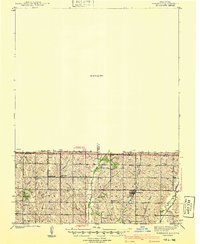 1940 Farragut1940 Print · USGSThe Iowa-Missouri state line serves as the anchor for this 1939 survey of Atchison, Fremont, and Page counties. Genealogists and local historians can trace the positions of vanished schoolhouses like Yale Sch and Emporia Sch, or locate family sites near Farmers City and Westboro.
 - 1940 Map of Kansas City
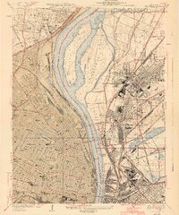
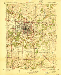
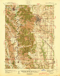
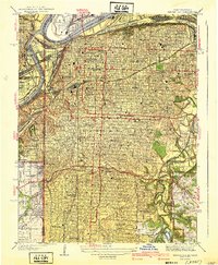 1940 Kansas City1940 Print · USGSKansas City's urban landscape is shown in remarkable detail just before the war, highlighting its massive rail yards and industrial riverfront. Genealogists and historians can trace neighborhood schools like Longfellow Sch, Central High Schools, and the resting places at Calvary Cemetery.3 unique versions available
 - 1940 Map of Granite City
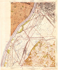
 1940 Granite City1940 Print · USGSThe industrial heart of the bi-state region comes alive in this 1940s survey of the riverfront between Illinois and Missouri. Researchers can trace the massive rail yards and river docks supporting Granite City, alongside historic landmarks like Union Station, St Louis University, and the Bellefontaine Cemetery.4 unique versions available
 - 1940 Map of West Plains
 1940 West Plains1940 Print · USGSWest Plains was a bustling Ozark rail hub just before the mid-century, surrounded by a landscape of family farms and valley schools. Genealogists can locate specific local landmarks like County Home, Smith Chapel, and the St Louis San Francisco rail corridor.
 - 1940 Map of Cedar Hill
 1940 Cedar Hill1940 Print · USGSJefferson County was a landscape of small river towns and hilltop schoolhouses just before the 1940s. Genealogists and local historians can trace family roots through landmarks like St Martins Ch, Morse Mill, and the many rural schools including Bethlehem Sch.
 - 1940 Map of Cahokia
 1940 Cahokia1940 Print · USGSThe industrial riverfront south of St Louis thrived in the early twentieth century as a massive rail and shipping hub. Trace the development of Cahokia and Dupo or locate landmarks like the U S Marine Hospital and the Lark Cem.3 unique versions available
 - 1940 Map of Taberville
 1940 Taberville1940 Print · USGSSettled along the northern banks of the Osage River just before the mid-century, this area of St. Clair County shows a landscape of small mines and rural schoolhouses. Genealogists can trace family landmarks like Ridgeway Cem or the sites of Gray's Mine and Johnson City.
 - 1940 Map of Eureka
 1940 Eureka1940 Print · USGSThe Missouri countryside west of St. Louis appears here just before the mid-century, defined by the twin river valleys of the Missouri and Meramec. You can trace the development of Eureka and Allenton along the St Louis San Francisco rail line, or find the CCC Camp and Wildhorse Creek Sch in the hills.
 - 1940 Map of Weldon Spring
 1940 Weldon Spring1940 Print · USGSThe Missouri River bottoms and St. Charles County uplands are captured here just before the Second World War. Researchers can trace family history through several rural landmarks, including Pitman Cem, Antioch Ch, and the lost river community of Hamburg.
 - 1940 Map of Columbia
 1940 Columbia1940 Print · USGSMid-century Columbia and the University of Missouri are captured here just before the post-war building boom transformed the campus and surrounding Boone County landscape. Researchers can locate vanished landmarks like the original Columbia Airport, the State Serum Plant, and historic rural schoolhouses including Bethel Sch and Keene Sch.
 - 1940 Map of Creve Coeur
 1940 Creve Coeur1940 Print · USGSWest of St. Louis in the late thirties, this area shows a transition from the Missouri River bottomlands to suburban townships and prestigious private clubs. Trace family roots at Fee Fee Cemetery or locate old school sites like Adams Sch and Spoede Sch.3 unique versions available
 - 1940 Map of Sweet Springs
 1940 Sweet Springs1940 Print · USGSWestern Missouri in the late thirties is revealed here as a landscape of interconnected river valleys and tightly knit rural communities. Genealogists and historians can trace family roots through numerous country schools and landmarks like High Hill Cem, Bleak Mound, and the Missouri Pacific rail line.
 - 1940 Map of Harwood
 1940 Harwood1940 Print · USGSVernon County farmland and rural rail towns are captured here at the end of the thirties, anchored by the Missouri Kansas Texas line. Trace early school locations like Robinson Sch and Lowe Sch alongside the historic town plats of Walker and Fair Haven.
 - 1940 Map of Roscoe
 1940 Roscoe1940 Print · USGSThe Osage and Sac rivers meet in this late 1930s Missouri survey, capturing the rural riverfront settlements of St. Clair and Cedar counties. Genealogists can trace family footprints at Roscoe Cem, Hardyville, and country schools like Motley Sch.2 unique versions available
 - 1940 Map of Kirkwood
 1940 Kirkwood1940 Print · USGSSt. Louis County shows its rapid suburban and institutional growth before the mid-century boom. Genealogists and historians can trace the rail-centered development of Kirkwood and find vanished landmarks like Windsor Springs and Hartman College.3 unique versions available
 - 1940 Map of Liberty
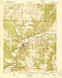
 1940 Liberty1940 Print · USGSClay County at the dawn of the 1940s shows a dense network of river-bottom railroads and hilltop college life. Genealogists can trace family landmarks like Withers Sch, the Odd Fellows Home, and the Depression-era Federal Transient Camp.2 unique versions available
 - 1940 Map of Kirksville
 1940 Kirksville1940 Print · USGSAdair County and the city of Kirksville are captured just before the 1940s, showing a landscape defined by crossing railroads and numerous small townships. Genealogists can locate dozens of rural landmarks, from Union Temple Ch to long-gone schoolhouses like Troy Mills Sch and Danforth Sch.
 - 1940 Map of Osceola
 1940 Osceola1940 Print · USGSOsceola and the Osage River valley are captured in the late 1930s, showing a landscape of riverfront camps and remote country schools. Researchers can locate the County Home, trace the St Louis - San Francisco rail line, or find family roots at Springstude Cem and Dunkard Ch.
 - 1940 Map of Bonner Springs
 1940 Bonner Springs1940 Print · USGSThe Kansas and Missouri rivers converge near these busy rail corridors just before the Second World War. Researchers can trace rural life through dozens of named schools like Mission Sch and the community center at Elm Grove Community Hall.3 unique versions available
 - 1940 Map of Williamsville
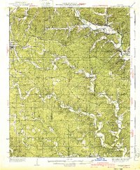 1940 Williamsville1940 Print · USGSThe eastern Ozarks at the start of the 1940s reveal a bustling rail-and-river economy centered on the junction of the Missouri Pacific and St Louis - San Francisco. Researchers can trace the unique immigrant history of Budapest or locate vanished landmarks like the Fire Tower CCC Camp and Barrett Mine.2 unique versions available
 - 1940 Map of North Kansas City
 1940 North Kansas City1940 Print · USGSThe industrial riverfront and Clay County uplands are documented here during the mid-1930s as the regional transport network matured. Genealogists and researchers can locate family landmarks like New Stark Cem, Bethel Ch, and the many rural schoolhouses serving Gashland and Barry.2 unique versions available
 - 1940 Map of Independence
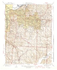 1940 Independence1940 Print · USGSIndependence and its eastern suburbs are shown here in the mid-1930s, caught between the industrial Missouri River bend and the rural ridges of Jackson County. Genealogists can trace family landmarks like Woodlawn Cemetery, the Sanitarium, and rural schools like Whiteoak Sch.2 unique versions available
 - 1940 Map of Filley
 1940 Filley1940 Print · USGSCedar County was a landscape of remote farmsteads and scattered rural schools at the end of the Depression. Genealogists can trace family footprints across dozens of local landmarks, from the Wright Cem and Tennessee Cem to the crossing at Ivy Bridge.2 unique versions available
Showing maps 1-25 of 362
Top cities of Missouri
- Kansas City historical maps
- St. Louis historical maps
- Springfield historical maps
- Columbia historical maps
- Independence historical maps
- Lee's Summit historical maps
See more
Top counties of Missouri
- Saint Louis County historical maps
- Jackson County historical maps
- Saint Charles County historical maps
- St. Louis historical maps
- Greene County historical maps
- Clay County historical maps
See more
Frequently asked questions
- What are the different types of historical maps available for Missouri?
- What is the oldest map of Missouri?
- Where can I purchase historical maps of Missouri for my home or office?
- Where can I download high-res historical maps of Missouri?
- Are there historical topographic maps available for Missouri?
- Is there historical aerial imagery available for Missouri?
- Where are historical maps of Missouri sourced from?