1910s Maps of New York
Explore 203 historic maps of New York from the 1910s. These maps offer a rare glimpse into what life looked like during the 1910s — showing old roads, neighborhoods, homes, and landmarks that have changed or disappeared over time.
Whether you're researching your family's past, planning a metal detecting trip, or studying how New York's landscape evolved across the 1910s, these high-resolution maps are a powerful tool for exploring the history of this region.
- Focus on a specific era: All maps on this page are from the 1910s, giving you a focused view of this time period.
- See what’s changed: Compare century-old streets, trails, and buildings to today's modern landscape using overlays and satellite layers.
- Research with precision: Use these maps for genealogy, historical research, land use analysis, or educational projects.
- View, download, or print: Maps are fully viewable online in high resolution, and can be downloaded or printed for your own records.
Start exploring New York's history through authentic maps from the 1910s. This is your window into the past.
New York maps
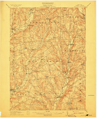
- 1910 Map of Ramapo
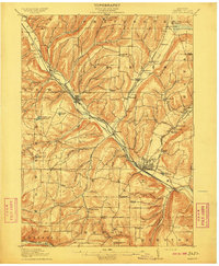
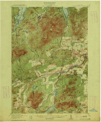
 1910 Ramapo1910 Print · USGSThe Ramapo Valley at the turn of the century served as a vital transit corridor between New York and New Jersey, dominated by rail lines and river industry. Genealogists and local historians can trace the foundations of Sloatsburg, Suffern, and Pearl River, alongside landmarks like the Ramapo Cem. and the Powder Works.6 unique versions available
 - 1910 Map of Neversink
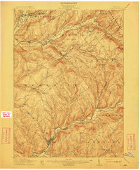
 1910 Neversink1910 Print · USGSSullivan and Ulster counties appear here in the early twentieth century, showing a region of mountain hamlets and sprawling ponds before major reservoir construction. Genealogists can trace family footprints in Grahamsville, Eureka, and Loch Sheldrake, or follow the Ontario and Western RR through Liberty.6 unique versions available
 - 1910 Map of Greenwood Lake
 1910 Greenwood Lake1910 Print · USGSThe Highlands of northern New Jersey and southern New York are shown here during a peak era of iron mining and rail expansion. Genealogists and industrial historians can trace the foundations of Sterling Furnace, Charlotteburg Mine, and the New Milford Sta. along the Erie Railroad.9 unique versions available
 - 1910 Map of Bath
 1910 Bath1910 Print · USGSSteuben County was a bustling corridor of rail and river commerce in the early twentieth century. Researchers can trace the lineage of local institutions like the State Soldiers and Sailors Home or find vanished schoolhouses such as Bucks School and Whites School.4 unique versions available
 - 1910 Map of Stony Creek
 1910 Stony Creek1910 Print · USGSThe southern Adirondacks at the turn of the century are captured here, centered on the intersection of Hamilton, Warren, and Saratoga counties. Genealogists can trace early outposts and hamlets like Harrisburg West Stony Creek PO, Hope Falls, and Griffin.7 unique versions available
 - 1910 Map of Hartwick, 1953 Print
 1910 Hartwick1953 Print · USGSOtsego County's rural landscape is meticulously detailed during the early twentieth century, showing a world of hillside farms and valley hamlets. Genealogists and historians can trace old homesteads and transport routes like the O & W RR near Mt Vision and South Hartwick.
 - 1910 Map of Canton, 1956 Print
 1910 Canton1956 Print · USGSSt. Lawrence County is captured here in the early twentieth century as a busy corridor of rail travel and river-powered industry. Researchers can locate family homesteads near Crary Mills, Langdon Corners, or the historic Brick Chapel along the Grass River.
 - 1910 Map of New Berlin, 1963 Print
 1910 New Berlin1963 Print · USGSThe Unadilla and Chenango river valleys are seen here in the early twentieth century as established rail corridors and farming hubs. Researchers can trace the N Y O & W R R line through Holmesville or locate family sites like Kings Settlement and the Dimmick Hollow School.
 - 1911 Map of Delhi
 1911 Delhi1911 Print · USGSDelaware County during the first decade of the twentieth century shows a landscape of rail-driven river towns and high hill farms. You can trace the historic routes of the Ulster and Delaware RR and locate local landmarks like the Elk Creek Church and Wakaqua Falls.5 unique versions available
 - 1911 Map of Canton
 1911 Canton1911 Print · USGSNorthern St. Lawrence County is captured here in the early twentieth century as a busy corridor of river-powered industry and rail transport. Genealogists and historians can trace the foundations of Canton and Potsdam or locate smaller rural hubs like Brick Chapel and Pyrites.4 unique versions available
 - 1911 Map of Monticello
 1911 Monticello1911 Print · USGSSullivan County at the height of its early resort era shows a landscape shaped by competing railroads and mountain valleys. Genealogists and historians can trace the New York Ontario and Western RR through Hurleyville Luzon Sta or locate the Delaware and Hudson Canal (Abandoned).6 unique versions available
 - 1911 Map of Antwerp
 1911 Antwerp1911 Print · USGSJefferson County was a landscape of bustling river towns and intersecting rail lines just after the turn of the century. Trace the early footprints of Antwerp and Sterlingville, or locate family landmarks like Bishops Corners and Woods Mill.6 unique versions available
 - 1911 Map of Lyon Mountain, 1956 Print
 1911 Lyon Mountain1956 Print · USGSThe northern Adirondacks at the peak of the iron era reveal a landscape of mining hamlets and mountain kilns. Genealogists can trace family footprints in Loudell PO, Standish, and Sugarbush, or follow the industrial path of the Delaware and Hudson RR.2 unique versions available
 - 1911 Map of Lowville, 1959 Print
 1911 Lowville1959 Print · USGSLewis County at the start of the 1910s reveals a thriving network of river-powered hamlets and rural school districts. Genealogists can locate family landmarks like Bushes Landing, Kirchnerville, and the Wisner School along the Black River valley.2 unique versions available
 - 1912 Map of New Berlin
 1912 New Berlin1912 Print · USGSChenango County's river valleys and dairy uplands are meticulously captured in this pre-war survey of the New Berlin area. Genealogists can locate family-named landmarks and institutions like Columbus Hill Church, Kings Settlement, and the Dimmick Hollow School.4 unique versions available
 - 1912 Map of Rochester
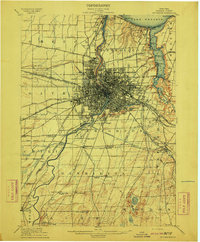 1912 Rochester1912 Print · USGSRochester and its surrounding Monroe County townships are shown here during a transformative era of canal and rail expansion. Genealogists can locate family-named stations and settlements like Maplewood Bealsburg PO, Mortimer, and Barnard along the busy tracks of the Lehigh Valley R. R.2 unique versions available
 - 1912 Map of Hartwick
 1912 Hartwick1912 Print · USGSOtsego County's rural heartland is captured here at the height of its rail-and-river economy in the years before the Great War. Genealogists can trace family homesteads near Burlington Flats, New Lisbon, and the tracks of the O & H Electric line.4 unique versions available
 - 1912 Map of Hammond
 1912 Hammond1912 Print · USGSThe rural borderlands of St. Lawrence and Jefferson counties are captured here in the early twentieth century. Genealogists and historians can trace defunct district schools like California School and Stark School, or locate the Old Iron Works and rail stops at South Hammond Oakvale Sta.4 unique versions available
 - 1912 Map of Number Four
 1912 Number Four1912 Print · USGSThe Adirondack wilderness of Herkimer and Lewis counties is captured here in the early twentieth century before modern development. Trace the remote waterways from the Oswegatchie River down to Soft Maple Dam or locate family landmarks near Balsam Flats and Stillwater Mtn.
 - 1912 Map of Mc Keever
 1912 Mc Keever1912 Print · USGSThe southwestern Adirondack wilderness comes into focus in this early twentieth-century survey, showcasing the arrival of the railroad in a landscape of logging camps. Genealogists and researchers can trace the development of Mc Keever and locate family-named sites like Millard's Camp, Porters Corners, and Becks Camp.8 unique versions available
 - 1912 Map of Ontario Beach
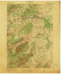
 1912 Ontario Beach1912 Print · USGSThe Lake Ontario shoreline near Rochester was a burgeoning hub of transit and tourism in the early twentieth century. Researchers can trace the path of the Grand View Beach Electric RR or locate landmarks like Genesee L. H. and Manitou Beach.
 - 1913 Map of Naples
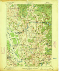
 1913 Naples1913 Print · USGSThe Finger Lakes region at the start of the twentieth century shows a landscape of deep waters and steep ridges connected by steam and rail. Trace the historic Steamboat Route on Canandaigua Lake and follow the rail lines to Naples or Prattsburg.
 - 1913 Map of Dannemora
 1913 Dannemora1913 Print · USGSClinton County's industrial and correctional history is frozen in time at the edge of the Adirondacks before the First World War. Trace the Chateaugay Branch rail line to the State Penitentiary or locate old schoolhouses like Grand Hill School.5 unique versions available
 - 1913 Map of Lowville
 1913 Lowville1913 Print · USGSLewis County in the early twentieth century is captured here as a landscape of river-powered industry and dispersed rural settlements. Genealogists can locate family-named landmarks like Petries Corners, trace the Lowville and Utica Line, and find dozens of local schools including Henry School and Osson School.5 unique versions available
 - 1913 Map of Lyon Mountain
 1913 Lyon Mountain1913 Print · USGSThe northern Adirondacks in the pre-war years were a landscape of mountain hamlets and industrial outposts. Genealogists and historians can trace the foundations of Lyon Mountain, locate the Loudell P.O., and follow the Delaware and Hudson RR through the high country.5 unique versions available
Showing maps 1-25
Top cities of New York
- New York historical maps
- Hempstead historical maps
- Brookhaven historical maps
- Islip historical maps
- Oyster Bay historical maps
- Buffalo historical maps
See more
Top counties of New York
- Kings County historical maps
- Queens County historical maps
- New York County historical maps
- Suffolk County historical maps
- Bronx County historical maps
- Nassau County historical maps
See more
Frequently asked questions
- What are the different types of historical maps available for New York?
- What is the oldest map of New York?
- Where can I purchase historical maps of New York for my home or office?
- Where can I download high-res historical maps of New York?
- Are there historical topographic maps available for New York?
- Is there historical aerial imagery available for New York?
- Where are historical maps of New York sourced from?