1980s Maps of New York
Explore 120 historic maps of New York from the 1980s. These maps offer a rare glimpse into what life looked like during the 1980s — showing old roads, neighborhoods, homes, and landmarks that have changed or disappeared over time.
Whether you're researching your family's past, planning a metal detecting trip, or studying how New York's landscape evolved across the 1980s, these high-resolution maps are a powerful tool for exploring the history of this region.
- Focus on a specific era: All maps on this page are from the 1980s, giving you a focused view of this time period.
- See what’s changed: Compare century-old streets, trails, and buildings to today's modern landscape using overlays and satellite layers.
- Research with precision: Use these maps for genealogy, historical research, land use analysis, or educational projects.
- View, download, or print: Maps are fully viewable online in high resolution, and can be downloaded or printed for your own records.
Start exploring New York's history through authentic maps from the 1980s. This is your window into the past.
New York maps
(120)- 1980 Map of Cambria
 1980 Cambria1980 Print · USGSNiagara County in the early eighties shows a mix of Cold War military presence and educational growth. Researchers can trace the layout of the Lockport Air Force Station, find St Peters Ch, or explore the CONRAIL rail corridor.
 - 1980 Map of Tonawanda West
 1980 Tonawanda West1980 Print · USGSThe Niagara River frontier in the early 1980s reveals a landscape of heavy industry, military aviation, and growing suburbs. Researchers can trace historic cemeteries like Holy Ghost Cem, local schools such as Duffy High Sch, and the layout of Grand Island.
 - 1980 Map of Clarence Center
 1980 Clarence Center1980 Print · USGSSuburban development meets rural Erie County during the early eighties as new residential tracts rise near established crossroads. Researchers can trace the Erie Canal near the Sulphur Springs Guard Lock or locate family roots at St Marys Cem and Clarence Center.
 - 1980 Map of Hunter
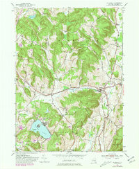
 1980 Hunter1980 Print · USGSThe Catskill high country comes into focus in this study of the mountain corridor before the modern era. Genealogists can trace family names at Evergreen Cem or locate historic parish sites like St Johns Ch and East Kill Valley Ch.
 - 1980 Map of Ransomville
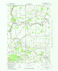
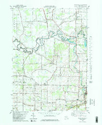
 1980 Ransomville1980 Print · USGSNiagara County's agricultural and industrial character is preserved here in the early eighties, from the Lake Ontario plains to the Tuscarora escarpment. Trace local family roots and historical land use through landmarks like Mt Hope Cem, the settlement at Model City, and the Tuscarora Indian Reservation.2 unique versions available
 - 1980 Map of Barker
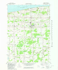 1980 Barker1980 Print · USGSNiagara County's fertile lakeside plains are captured here in the early eighties, showing the rural communities of Barker and Somerset. Researchers can locate family landmarks such as the Quaker Cemetery, the Quaker Road Church, and the unique Barker Central School Airport.
 - 1980 Map of Lockport
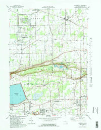
 1980 Lockport1980 Print · USGSLockport and the surrounding Niagara County countryside are captured here in the early eighties, showing the city's industrial core and rural townships. Researchers can trace local landmarks like St Bridgets Ch, the County Fairgrounds, and the path of the ERIE CANAL.3 unique versions available
 - 1980 Map of Willsboro
 1980 Willsboro1980 Print · USGSThe Lake Champlain shoreline at the edge of the Adirondacks was a bustling corridor of rail and water transport in the late twentieth century. Researchers can trace the Delaware and Hudson line between Willsboro and Essex, or locate family sites like Brookfield Cem and St Josephs Ch.
 - 1980 Map of Wolcottsville
 1980 Wolcottsville1980 Print · USGSThe rural borders of Erie and Niagara counties come alive in the late twentieth century as this survey follows the winding Tonawanda Creek. Trace the sites of Swifts Mills, Dancer Cem, and the old rail connections at Akron Junction.2 unique versions available
 - 1980 Map of Ft Niagara
 1980 Ft Niagara1980 Print · USGSThe international border at the mouth of the Niagara River is captured here in the 1980s, showing a landscape defined by military history and lakefront growth. Researchers can trace the layout of Niagara-On-The-Lake, Youngstown, and the grounds of Fort Niagara State Park.
 - 1980 Map of Tonawanda East
 1980 Tonawanda East1980 Print · USGSNiagara and Erie counties meet at the historic canal in the early eighties as suburban growth reshapes the landscape. Genealogists and local historians can trace the development of North Tonawanda, the grounds of White Chapel Memorial Cem, and small hamlets like Wendelville.
 - 1980 Map of Westport, 1981 Print
 1980 Westport1981 Print · USGSLake Champlain divides the New York Adirondacks from the Vermont plains in the early eighties, showing a landscape defined by water and rail. Researchers can trace family sites at Riverside Cem and Prospect Cem, or locate landmarks like Camp Dudley and the Delaware and Hudson railroad.3 unique versions available
 - 1980 Map of Hensonville, 1981 Print
 1980 Hensonville1981 Print · USGSHigh peaks and narrow kills define these Greene County highlands during the late twentieth century. Researchers can trace the Old Railroad Grade and find family names at cemeteries near Hensonville and Cornwallville.2 unique versions available
 - 1980 Map of Greenville, 1981 Print
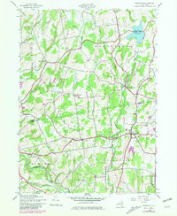 1980 Greenville1981 Print · USGSThe Albany and Greene County borderlands in the early eighties show a landscape of hamlets connected by winding creeks and country roads. Genealogists and historians can trace family burial sites like Locust Cem and rural settlements such as South Westerlo and Norton Hill.
 - 1980 Map of Lewiston, 1981 Print
 1980 Lewiston1981 Print · USGSNiagara County and the international border are seen here in the 1980s, showcasing the massive power infrastructure along the river. Genealogists and researchers can locate Riverdale Cemetery, Stella Niagara Seminary, and the unique Our Lady of Fatima Shrine.
 - 1980 Map of Kingston West, 1981 Print
 1980 Kingston West1981 Print · USGSKingston and the Esopus Creek valley are shown here in the 1980s as the region balanced its colonial roots with modern infrastructure. Researchers can trace family sites at the Old Dutch Ch Cem, the old West Hurley District Sch No 8, or along the CONRAIL line.
 - 1980 Map of Hyde Park, 1981 Print
 1980 Hyde Park1981 Print · USGSDutchess and Ulster counties meet along the Hudson River in the early eighties, showcasing a landscape of historic estates and religious seminaries. Genealogists can trace the Stoutenburgh Cem, locate the F D Roosevelt Home National Historic Site, or explore landmarks like Indian Rock.2 unique versions available
 - 1980 Map of Kinderhook, 1981 Print
 1980 Kinderhook1981 Print · USGSColumbia County in the early eighties retains its storied village character even as modern parkways and rail lines intersect the landscape. Genealogists can trace family footprints near Kinderhook at the House of History or locate early settlements along the Valatie Kill.
 - 1980 Map of Hillsdale, 1981 Print
 1980 Hillsdale1981 Print · USGSThe hills of Columbia County are captured here in the early eighties, showing a landscape defined by dairy country and growing summer retreats. Genealogists can locate family-named sites like Crum Cem and Collins Cem, or trace the New York Central rail line.
 - 1980 Map of Hudson South, 1981 Print
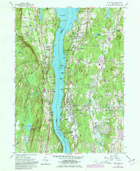
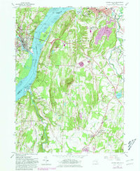 1980 Hudson South1981 Print · USGSThe Hudson River valley at the start of the 1980s reveals a blend of historic estates, maritime industry, and established river towns. Genealogists and historians can trace riverside landings and local institutions like Olana Historic Site, St Anthonys Seminary, and the Germantown Reformed Cemetery.
 - 1980 Map of Hudson North, 1981 Print
 1980 Hudson North1981 Print · USGSThe Hudson River valley at the dawn of the 1980s reveals a landscape of industrial river towns and sprawling institutions. Genealogists and historians can trace family sites at Limestreet Cem or explore the rail-linked history of Stockport Sta and Newton Hook.
 - 1980 Map of Niagara Falls, 1981 Print
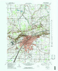
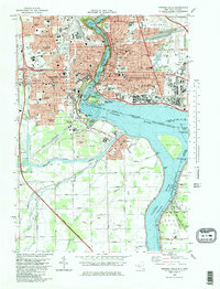 1980 Niagara Falls1981 Print · USGSNiagara Falls and its international surrounds are captured in the early eighties as a hub of hydropower and tourism. Genealogists and historians can trace neighborhood schools like Gaskill High School, resting places like Oakwood Cemetery, and rail junctions at Montrose Junction.
 - 1980 Map of Port Henry, 1981 Print
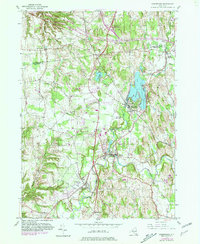
 1980 Port Henry1981 Print · USGSLake Champlain's narrows were a hub of activity in the late twentieth century, balancing heavy industry with significant colonial heritage. Genealogists and historians can trace Fort St Frederic Ruins, family cemeteries like Spear Cem, and the path of the Delaware and Hudson railroad.
 - 1980 Map of Willsboro Bay, 1981 Print
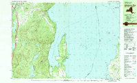 1980 Willsboro Bay1981 Print · USGSLake Champlain and the eastern edge of the Adirondacks meet in the early eighties, revealing a landscape of shoreline camps and mountain peaks. Trace the Delaware and Hudson rail line through Port Douglass or locate historic family spots near Highlands Forge Lake and Schuyler Island.2 unique versions available
 - 1980 Map of Bradford, 1982 Print
 1980 Bradford1982 Print · USGSNorthern Pennsylvania's oil country and deep forests are captured here during the 1980s. Genealogists and researchers can trace rail-side settlements like Kushequa, Gifford, and Lewis Run or locate specific Oil and Gas Field sites across the plateau.
Showing maps 1-25 of 120
Top cities of New York
- New York historical maps
- Hempstead historical maps
- Brookhaven historical maps
- Islip historical maps
- Oyster Bay historical maps
- Buffalo historical maps
See more
Top counties of New York
- Kings County historical maps
- Queens County historical maps
- New York County historical maps
- Suffolk County historical maps
- Bronx County historical maps
- Nassau County historical maps
See more
Frequently asked questions
- What are the different types of historical maps available for New York?
- What is the oldest map of New York?
- Where can I purchase historical maps of New York for my home or office?
- Where can I download high-res historical maps of New York?
- Are there historical topographic maps available for New York?
- Is there historical aerial imagery available for New York?
- Where are historical maps of New York sourced from?