1950s Maps of New York
Explore 556 historic maps of New York from the 1950s. These maps offer a rare glimpse into what life looked like during the 1950s — showing old roads, neighborhoods, homes, and landmarks that have changed or disappeared over time.
Whether you're researching your family's past, planning a metal detecting trip, or studying how New York's landscape evolved across the 1950s, these high-resolution maps are a powerful tool for exploring the history of this region.
- Focus on a specific era: All maps on this page are from the 1950s, giving you a focused view of this time period.
- See what’s changed: Compare century-old streets, trails, and buildings to today's modern landscape using overlays and satellite layers.
- Research with precision: Use these maps for genealogy, historical research, land use analysis, or educational projects.
- View, download, or print: Maps are fully viewable online in high resolution, and can be downloaded or printed for your own records.
Start exploring New York's history through authentic maps from the 1950s. This is your window into the past.
New York maps
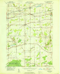
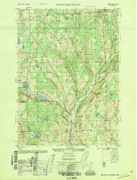
(556)- 1950 Map of Buffalo NW
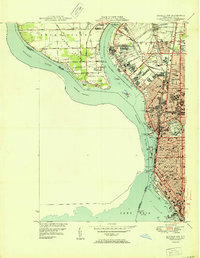 1950 Buffalo NW1950 Print · USGSThe Niagara River and Grand Island are shown in detail during the early fifties, capturing Buffalo's northern expansion. Genealogists and historians can locate dozens of local institutions like Lafayette High Sch, Mt Olivet Cem, and Bell Airport.2 unique versions available
 - 1950 Map of Bridport
 1950 Bridport1950 Print · USGSThe rural landscapes of Bridport and Shoreham come alive in the 1950s, showing a world of hilltop farms and winding valley streams. Genealogists can locate family names at Pine Hill Cem or Lakeview Cem, and trace the grounds of All Saints Chapel and School No 6.2 unique versions available
 - 1950 Map of Corfu
 1950 Corfu1950 Print · USGSThe Erie and Genesee County borderlands thrived at mid-century as a vital railroad corridor between Buffalo and Batavia. Researchers can trace the path of four major rail lines and locate rural landmarks like Brick House Corners, School No. 13, and Fargo.2 unique versions available
 - 1950 Map of Newfane
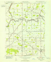
 1950 Newfane1950 Print · USGSNiagara County's lakefront and agricultural heartland are captured here at mid-century as the region's rural character remained firmly intact. Researchers can trace family sites near Olcott and Newfane, locating specific landmarks like Sawyer Cem, School No 6, and the New York Central Railroad.
 - 1950 Map of Wolcottsville
 1950 Wolcottsville1950 Print · USGSNiagara and Erie Counties are captured here at the start of the 1950s, showing a transition from rural farming to structured township growth. Researchers can trace family history through numerous district schools and landmarks like Swifts Mills, Akron Junction, and the Clarence Center Church.
 - 1950 Map of Elmira
 1950 Elmira1950 Print · USGSThe Finger Lakes region thrived in the late 1940s as a hub of industry and transport. Trace family roots and vanished landmarks near Seneca Lake or explore the rail lines of the Erie RR and the sprawling Seneca Ordnance Depot.2 unique versions available
 - 1950 Map of Lockport
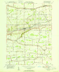
 1950 Lockport1950 Print · USGSLockport and its surrounding townships thrive along the Erie Canal in the post-war era. Genealogists and local historians can trace legacy sites like Cold Spring Cem, the Chapel of the Good Shepherd, and the International Railway corridor.
 - 1950 Map of Greene
 1950 Greene1950 Print · USGSThe Chenango River valley in the years after the war shows a landscape of rail-connected villages and historic turnpikes. Genealogists can locate family burial sites at Sylvan Lawn Cem and Horton Cem or trace the path of the Catskill Turnpike.
 - 1950 Map of Ransomville
 1950 Ransomville1950 Print · USGSMid-century Niagara County is captured here at a time when the Tuscarora Indian Reservation and the New York Central Railroad defined the local landscape. Genealogists can trace family footprints through numerous rural landmarks like St Michaels Cem, Model City, and School No 11.
 - 1950 Map of Clarence Center
 1950 Clarence Center1950 Print · USGSMidcentury Western New York is captured here as rural townships began to evolve around the Erie Canal and Tonawanda Creek. Genealogists and local historians can locate early district schools, the Sulphur Springs Guard Lock, and hamlets like Swormville and Hodgeville Sta.2 unique versions available
 - 1950 Map of Gasport
 1950 Gasport1950 Print · USGSNiagara County's canal and rail corridor is captured here at mid-century, following the Erie Canal through Gasport. Genealogists and local historians can trace the foundations of several hamlets including Reynales Basin, Terrys Corner, and Orangeport Settlement.
 - 1950 Map of Sharon
 1950 Sharon1950 Print · USGSLitchfield County’s corner of the Northwest Hills was a landscape of boarding schools and iron-industry remnants in the mid-twentieth century. Researchers can trace the grounds of The Hotchkiss Sch or explore old village sites like Lime Rock and Ore Hill.2 unique versions available
 - 1950 Map of Binghamton
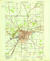
 1950 Binghamton1950 Print · USGSBinghamton and the surrounding Southern Tier are shown in the mid-century era, highlighting the intricate rail and river networks that drove local industry. Researchers can trace the path of the Erie Railroad and locate landmarks from Otsego Lake to Sidney Mountain.2 unique versions available
 - 1950 Map of Tonawanda East
 1950 Tonawanda East1950 Print · USGSNiagara and Erie counties meet along the canal and river during this postwar period of industrial activity and suburban expansion. Genealogists and local historians can trace the foundations of Martinsville and Hodgeville, or locate family sites near Wheatfield Cemetery and School No. 10.2 unique versions available
 - 1950 Map of Egremont
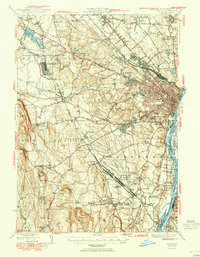
 1950 Egremont1950 Print · USGSThe Berkshires of the mid-twentieth century are captured here along the New York border, showing the rural character of the Egremont hamlets. Researchers can trace historic property lines near Egremont Plain or locate old landmarks like the Great Barrington Airport and Prospect Lake.
 - 1950 Map of Albany
 1950 Albany1950 Print · USGSMid-century Albany and its burgeoning suburbs are captured here at a peak of rail and river commerce. Genealogy and local history researchers can trace the New York Central lines to the Selkirk Yards or find family landmarks like Keefers Corners and Bethlehem Church.
 - 1950 Map of Knowlesville
 1950 Knowlesville1950 Print · USGSOrleans County at mid-century remains a landscape defined by the historic Erie Canal and the transit lines of the New York Central. Genealogists and local historians can trace family plots at Millville Cem or locate old schoolhouses and settlements like East Shelby and West Barre.3 unique versions available
 - 1950 Map of Lancaster
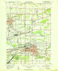 1950 Lancaster1950 Print · USGSErie County at the mid-century mark shows a landscape of burgeoning suburbs and vital rail corridors. Genealogists and researchers can trace family landmarks like St Marys High School, the Transit Cem, and old district sites like School No 8.
 - 1950 Map of Buffalo NE
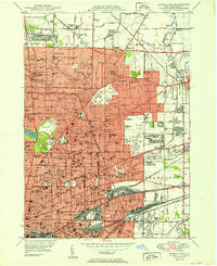 1950 Buffalo NE1950 Print · USGSBuffalo and its northeastern suburbs in the mid-twentieth century show a dense urban fabric of streetcar-era neighborhoods and burgeoning park systems. Genealogists and historians can trace family locations through dozens of numbered schools, large cemeteries like Forest Lawn, and industrial corridors near Sloan and Walden.
 - 1950 Map of Clarence
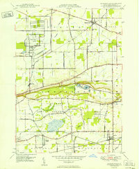
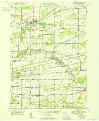 1950 Clarence1950 Print · USGSMid-century Erie County comes into focus through this survey of the rail-and-road network connecting Clarence and Alden. You can trace old property contexts via landmarks like Trinity Ch, Mt Olive Cem, and the various numbered schools scattered across the township lines.
 - 1950 Map of Smithville Flats
 1950 Smithville Flats1950 Print · USGSMid-century Chenango County remains a landscape of dairy farms and small hamlets before modern development altered the rural character. Trace ancestral roots at Westview Cem, locate vanished schoolhouses like School No 1, and explore the banks of Genegantslet Creek.
 - 1950 Map of Glens Falls
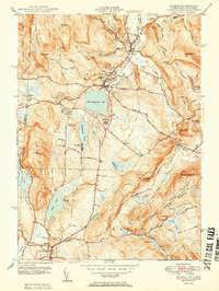
 1950 Glens Falls1950 Print · USGSThe Adirondacks and the Green Mountains meet in this mid-century survey of the New York and Vermont borderlands. Researchers can trace the industrial rail corridors of the Rutland RR and Delaware & Hudson RR connecting Glens Falls, Rutland, and the shores of Lake George.
 - 1950 Map of Tonawanda West
 1950 Tonawanda West1950 Print · USGSNiagara Falls and North Tonawanda are captured during a period of major post-war industrial and suburban growth. Researchers can trace the development of Cayuga Island, find local schools like Gratwick Sch, and locate family plots at White Haven Cem.
 - 1950 Map of Lake Champlain
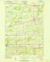
 1950 Lake Champlain1950 Print · USGSThe Lake Champlain valley and its surrounding peaks are captured in detail during the late 1940s, showing the vital rail and road connections between New York and Vermont. Researchers can trace the routes of the Central Vermont Railway or locate old industrial centers like Mineville and Witherbee.2 unique versions available
 - 1950 Map of Orchard Park
 1950 Orchard Park1950 Print · USGSSoutheast of Buffalo in the early fifties, this region shows a landscape of small townships and emerging suburban hubs. Researchers can locate numerous local institutions like Michael Road School, trace the Pennsylvania RR, or find the historic Willink settlement.
Showing maps 1-25 of 556
Top cities of New York
- New York historical maps
- Hempstead historical maps
- Brookhaven historical maps
- Islip historical maps
- Oyster Bay historical maps
- Buffalo historical maps
See more
Top counties of New York
- Kings County historical maps
- Queens County historical maps
- New York County historical maps
- Suffolk County historical maps
- Bronx County historical maps
- Nassau County historical maps
See more
Frequently asked questions
- What are the different types of historical maps available for New York?
- What is the oldest map of New York?
- Where can I purchase historical maps of New York for my home or office?
- Where can I download high-res historical maps of New York?
- Are there historical topographic maps available for New York?
- Is there historical aerial imagery available for New York?
- Where are historical maps of New York sourced from?