1920s Maps of New York
Explore 60 historic maps of New York from the 1920s. These maps offer a rare glimpse into what life looked like during the 1920s — showing old roads, neighborhoods, homes, and landmarks that have changed or disappeared over time.
Whether you're researching your family's past, planning a metal detecting trip, or studying how New York's landscape evolved across the 1920s, these high-resolution maps are a powerful tool for exploring the history of this region.
- Focus on a specific era: All maps on this page are from the 1920s, giving you a focused view of this time period.
- See what’s changed: Compare century-old streets, trails, and buildings to today's modern landscape using overlays and satellite layers.
- Research with precision: Use these maps for genealogy, historical research, land use analysis, or educational projects.
- View, download, or print: Maps are fully viewable online in high resolution, and can be downloaded or printed for your own records.
Start exploring New York's history through authentic maps from the 1920s. This is your window into the past.
New York maps
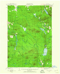
(60)- 1920 Map of Long Eddy
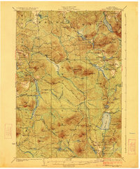
 1920 Long Eddy1920 Print · USGSThe Delaware River borderlands come alive in the 1920s as a hub of rail activity and riverfront commerce. Genealogists can locate family names near landmarks like Peckville P O, Equinunk, and rural schoolhouses like the South Branch School.3 unique versions available
 - 1920 Map of Bridgeport
 1920 Bridgeport1920 Print · USGSCoastal Connecticut comes alive in the early twentieth century as a hub of maritime commerce and industrial growth. Researchers can trace the development of Bridgeport and Milford, or locate specific landmarks like Charles Island and Beardsley Park.
 - 1920 Map of Rochester
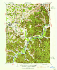
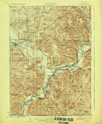
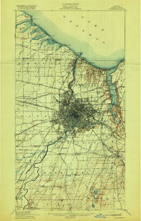 1920 Rochester1920 Print · USGSRochester and its surrounding townships thrive at the height of the rail and canal era during the early 1920s. Researchers can trace the original routes of the Barge Canal and locate specific sites like the State Industrial School or South Greece Station.5 unique versions available
 - 1920 Map of Childwold, 1954 Print
 1920 Childwold1954 Print · USGSIn the Adirondack interior during the early 1920s, this area showcases a network of timber camps and early sporting clubs. Researchers can trace the riverfront development of Hollywood and Childwold, or locate landmarks like the Shur-leff Hotel and Kildare.2 unique versions available
 - 1920 Map of Damascus, 1956 Print
 1920 Damascus1956 Print · USGSThe Upper Delaware River valley at the start of the 1920s shows a landscape of river-fronting hamlets and upland dairy farms. Genealogists can locate numerous rural schoolhouses and churches, such as Kester School, Smith Hill Church, and the Oil Pumping Station at Cochecton.2 unique versions available
 - 1921 Map of Plainfield
 1921 Plainfield1921 Print · USGSNew Jersey's industrial corridor meets the ridges of the First and Second Mountains in the early twenties. Genealogists can trace family names and small settlements like Raritan Landing, Smalleytown, and the grounds of the New Jersey Reformatory.
 - 1921 Map of Cranberry Lake
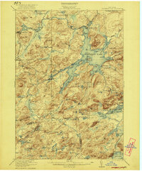 1921 Cranberry Lake1921 Print · USGSIn the early 1920s, this area of the Adirondacks was a nexus of wilderness and industry, from the waters of Cranberry Lake to the iron operations at Benson Mines. Researchers can trace the early grounds of the State Ranger School and follow the New York Central RR through Wanakena.7 unique versions available
 - 1921 Map of Gardiners Island
 1921 Gardiners Island1921 Print · USGSThe maritime landscape of eastern Long Island is detailed here in the years following the Great War. Researchers can trace historic shorelines and landings like Quincetree Landing, locate the military grounds of Fort Terry, or find family-named sites such as Barnes Landing and Hicks.
 - 1921 Map of New London
 1921 New London1921 Print · USGSCoastal Connecticut thrived between the world wars as a strategic naval and rail hub. Genealogists and historians can trace the foundations of local life through the Norwich State Hospital, the sprawling US Naval Station, and small hamlets like Gales Ferry or Flanders Village.
 - 1921 Map of Long Eddy
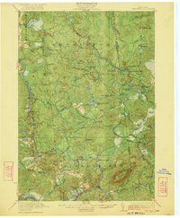
 1921 Long Eddy1921 Print · USGSThe Delaware River borderlands are captured here in the early twenties, showing a network of small upland communities and river crossings. Genealogists can trace family footprints through numerous rural schoolhouses and landmarks like Read Cemetery, Abrahamsville, and the Ferry.
 - 1921 Map of Childwold
 1921 Childwold1921 Print · USGSThe Adirondack wilderness in the early twenties was a landscape of remote sporting clubs and isolated river outposts. Genealogists and historians can trace old homesteads and landmarks like the Shurtleff Hotel, Childwold School, and the long-vanished community of Hollywood.
 - 1921 Map of Nicholville
 1921 Nicholville1921 Print · USGSUpper St. Lawrence and Franklin counties come alive in the early twentieth century as a landscape of timber-driven river towns and rural school districts. Genealogists can trace family footprints near St Regis Falls, Dickinson Center, and numerous rural sites like Harper School or Joe Indian.4 unique versions available
 - 1921 Map of Easthampton
 1921 Easthampton1921 Print · USGSThe eastern tip of Long Island comes alive in the early twentieth century, showing a maritime landscape defined by rail and sea. Genealogy and history buffs can trace the Long Island R. R. through Easthampton or locate the coastal Georgica L.S.S. and the settlement at Promised Land.
 - 1921 Map of Stonington
 1921 Stonington1921 Print · USGSCoastal Connecticut and Rhode Island meet here between the wars, where river and rail drive the regional economy. Genealogists can trace family footprints in North Stonington and Westerly, or locate the Silex Mine and the Light House at Stonington.
 - 1921 Map of Livingston Manor, 1952 Print
 1921 Livingston Manor1952 Print · USGSSullivan County in the early twenties is captured here as a landscape of timber processing and rail-connected mountain towns. Genealogists and historians can trace numerous rural districts like the Ireland School or find specific industrial sites such as the Acid Plant and Dye Works.2 unique versions available
 - 1921 Map of Stark, 1956 Print
 1921 Stark1956 Print · USGSSt. Lawrence County in the early twenties shows a landscape shaped by logging and the Adirondack wilderness. Researchers can trace the path of the Lumber RR, locate early rural sites like Glendale Mill and Cold Brook School, or find the secluded Stillwater Club.2 unique versions available
 - 1921 Map of Santa Clara, 1960 Print
 1921 Santa Clara1960 Print · USGSFranklin County's deep woods and timber-driven rail lines are captured here in the early 1920s. Genealogists and historians can locate rural schoolhouses like School No 7 and vanished logging stops along the Brooklyn Cooperage RR or near Santa Clara.2 unique versions available
 - 1922 Map of White Lake
 1922 White Lake1922 Print · USGSSullivan County's lake-strewn highlands appear here in the early twenties, showing a landscape defined by small mountain hamlets and rural school districts. Genealogists can trace family names through landmarks like Stewart Cemetery, Bauer's Mill, and Mount Hope School.6 unique versions available
 - 1922 Map of Childwold
 1922 Childwold1922 Print · USGSThe St. Lawrence County wilderness in the early twenties is a landscape of isolated camps and early Adirondack outposts. Local historians can locate vanished sites like the Shurtleff Hotel or trace the early foundations of Childwold and Hollywood near the Jordan River.4 unique versions available
 - 1922 Map of Randolph, 1955 Print
 1922 Randolph1955 Print · USGSCattaraugus County in the early twenties shows a landscape of river-valley commerce and mountain parkland. Genealogists can locate dozens of country schoolhouses like Archer Hill School and vanished rail stops such as Onoville Sta and Elkdale Sta.2 unique versions available
 - 1922 Map of Andes, 1955 Print
 1922 Andes1955 Print · USGSThe East Branch Delaware River valley is captured in the 1920s before the creation of the Pepacton Reservoir. Researchers can trace the original locations of Pepacton, Shavertown, and Union Grove, alongside numerous rural schoolhouses like Basin Clove School and Arbuckle School.2 unique versions available
 - 1923 Map of Santa Clara
 1923 Santa Clara1923 Print · USGSFranklin County's North Country is captured here in the early twenties, showing a landscape of timber-driven rail lines and mountain hamlets. Researchers can trace the New York Central Railroad through Santa Clara or locate the old McCollom School and Everton settlement.5 unique versions available
 - 1923 Map of Damascus
 1923 Damascus1923 Print · USGSThe Delaware River valley thrived as a corridor for rail and industry in the early twenties. Genealogists and historians can trace family-named landmarks like Stanton Corner or locate vanished infrastructure like the Oil Pumping Station and Nobody Station School.5 unique versions available
 - 1923 Map of Randolph
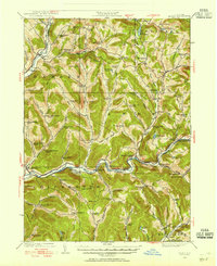
 1923 Randolph1923 Print · USGSCattaraugus County's southern borderlands are captured here in the early 1920s, showing a landscape defined by the winding Allegheny River and burgeoning state park. Genealogists can trace family footprints at the Wolf Run Elko PO, Oldtown School, or the many rural schoolhouses like Bunker Hill School.4 unique versions available
 - 1923 Map of Long Eddy
 1923 Long Eddy1923 Print · USGSThe Delaware River valley thrived in the 1920s as a rail and timber hub between New York and Pennsylvania. Genealogists can trace family roots through the many rural schoolhouses and riverside settlements like Lordville, Equinunk, and Fishs Eddy.5 unique versions available
Showing maps 1-25 of 60
Top cities of New York
- New York historical maps
- Hempstead historical maps
- Brookhaven historical maps
- Islip historical maps
- Oyster Bay historical maps
- Buffalo historical maps
See more
Top counties of New York
- Kings County historical maps
- Queens County historical maps
- New York County historical maps
- Suffolk County historical maps
- Bronx County historical maps
- Nassau County historical maps
See more
Frequently asked questions
- What are the different types of historical maps available for New York?
- What is the oldest map of New York?
- Where can I purchase historical maps of New York for my home or office?
- Where can I download high-res historical maps of New York?
- Are there historical topographic maps available for New York?
- Is there historical aerial imagery available for New York?
- Where are historical maps of New York sourced from?