1940s Maps of New York
Explore 832 historic maps of New York from the 1940s. These maps offer a rare glimpse into what life looked like during the 1940s — showing old roads, neighborhoods, homes, and landmarks that have changed or disappeared over time.
Whether you're researching your family's past, planning a metal detecting trip, or studying how New York's landscape evolved across the 1940s, these high-resolution maps are a powerful tool for exploring the history of this region.
- Focus on a specific era: All maps on this page are from the 1940s, giving you a focused view of this time period.
- See what’s changed: Compare century-old streets, trails, and buildings to today's modern landscape using overlays and satellite layers.
- Research with precision: Use these maps for genealogy, historical research, land use analysis, or educational projects.
- View, download, or print: Maps are fully viewable online in high resolution, and can be downloaded or printed for your own records.
Start exploring New York's history through authentic maps from the 1940s. This is your window into the past.
New York maps
(832)- 1940 Map of Canaseraga
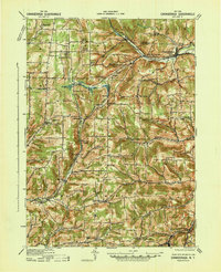 1940 Canaseraga1940 Print · USGSAllegany County's rural township structure is captured here just before the mid-century, showing a landscape tied together by local district schools and the Erie railroad. Researchers can locate early homesteads near Brewer Corners, trace the rail sidings at Garwoods Sta, or find ancestral landmarks like the County House and Jersey Hill School.2 unique versions available
 - 1940 Map of Ramsey
 1940 Ramsey1940 Print · USGSNorthern Bergen County in the late thirties is caught between its mountain wilderness and the rail-driven growth of the valley. Researchers can trace the Erie railroad line through Ramsey or locate historic estates and camps like Skylands and Camp Yaw-Paw.2 unique versions available
 - 1940 Map of Stark
 1940 Stark1940 Print · USGSSt. Lawrence County was a landscape of remote logging camps and private sporting clubs during the interwar years. Genealogists can locate family outposts like Sellecks Cors or trace the early rural education system at Littlejohn School and Cold Brook School.
 - 1940 Map of Port Leyden
 1940 Port Leyden1940 Print · USGSUpper Lewis County at the start of the 1940s reveals a landscape shaped by the BLACK RIVER and the rail industry. Researchers can trace historic homesteads near Constableville, industrial sites at Goulds Mill, and the riverside Leyden Station PO.
 - 1940 Map of Weehawken
 1940 Weehawken1940 Print · USGSBergen and Hudson Counties are shown just before the wartime industrial boom, highlighting a landscape where massive rail yards met expansive tidal marshes. Researchers can trace ancestral roots through dozens of local landmarks like Flower Hill Cem, Bendix Airport, and the Hudson County Penitentiary.3 unique versions available
 - 1940 Map of Schuylerville
 1940 Schuylerville1940 Print · USGSSaratoga and Washington Counties are shown here just before the mid-century, defined by the industrial river towns and the grounds of the Saratoga Battlefield. Genealogists can trace family names at Clarks Corners or Quaker Springs and locate early 20th-century landmarks like the Saratoga Battle Monument.3 unique versions available
 - 1940 Map of South Amboy
 1940 South Amboy1940 Print · USGSCoastal Middlesex County at the dawn of the 1940s reveals a landscape of heavy rail, maritime commerce, and emerging state parks. Local historians can trace the paths of the Raritan River RR, find the Polish Cem, or locate the Great Beds LH off the shore.2 unique versions available
 - 1940 Map of Brewerton
 1940 Brewerton1940 Print · USGSThe northern reaches of Onondaga County are captured here just before the war, centered on the historic Oneida River and canal systems. Researchers can trace the era's rural infrastructure through Woodard Sta, the Peat Swamp, and old landmarks like Morgan Ch.
 - 1940 Map of Nyack, 1952 Print
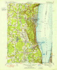 1940 Nyack1952 Print · USGSThe Hudson River shoreline and Rockland County interior are captured here just before mid-century suburban expansion. Researchers can trace the extensive grounds of the Rockland State Hospital, the paths of the West Shore RR, and historic sites like Sneden Landing.
 - 1940 Map of Cicero, 1957 Print
 1940 Cicero1957 Print · USGSOneida Lake’s southern shoreline was still largely rural and agricultural in the years before the war. Genealogists and local historians can trace family-named landmarks and early district schools like Van Anthrup Sch and the Cobblestone Sch.
 - 1941 Map of Cleveland
 1941 Cleveland1941 Print · USGSOneida Lake’s central waters and the surrounding shorelines are captured here in the early 1940s, highlighting a landscape of rail-connected villages and rural school districts. Genealogists can locate family landmarks like Smith Ridge Cem or trace the path of the New York Ontario and Western RR through Bernhard Bay.2 unique versions available
 - 1941 Map of Cattaraugus
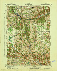 1941 Cattaraugus1941 Print · USGSWestern New York’s rural townships are captured here just before the mid-century, from the Cattaraugus Indian Reservation to the valley of Little Valley. Genealogists can trace dozens of early schoolhouses and local hamlets like Bagdad, Eddyville, and Five Points.
 - 1941 Map of Cherry Creek
 1941 Cherry Creek1941 Print · USGSChautauqua and Cattaraugus counties are captured here at the dawn of the 1940s, when the Erie railroad still bound these rural townships together. Genealogists can trace family footprints through numerous small villages like Forestville, South Dayton, and Charlotte Center.
 - 1941 Map of Kinzua
 1941 Kinzua1941 Print · USGSThe Allegheny River valley and the Cornplanter Indian Reservation are shown here in the years before mid-century dam projects forever changed the landscape. Researchers can trace the river-level Pennsylvania Railroad, the Kinzua Coal Mine, and now-submerged settlements like Kinzua and Corydon.3 unique versions available
 - 1941 Map of South Amboy
 1941 South Amboy1941 Print · USGSCoastal Middlesex County comes alive in this pre-war survey, showing the busy maritime and rail corridors between the Raritan River and the bay. Researchers can trace the layout of South Amboy, locate the Polish Cem, and find the U S Military Reservation.2 unique versions available
 - 1941 Map of Chautauqua
 1941 Chautauqua1941 Print · USGSChautauqua Lake was a bustling hub of rail and water travel in the early 1940s. Genealogists and local historians can trace family-named sites like Starr Farm and Jones Corners alongside the path of the Chautauqua Traction Co.
 - 1941 Map of Bay Shore West
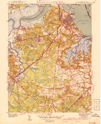
 1941 Bay Shore West1941 Print · USGSCoastal Suffolk County comes to life during the early 1940s, showing the South Shore villages as the Long Island suburb began to take shape. Researchers can trace the layout of early school districts like the Union Free Sch or find local landmarks such as the Babylon Yacht Club and St Patricks Ch.
 - 1941 Map of Angelica
 1941 Angelica1941 Print · USGSAllegany County during the early years of the Second World War was defined by its river-valley rail lines and high-country hamlets. Researchers can trace the legacy of Houghton College, the impact of the Caneadea Dam, and find vanished crossroads like Aristotle and McGrawville.
 - 1941 Map of Plattsburg
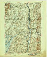
 1941 Plattsburg1941 Print · USGSLake Champlain was a critical corridor of military and transport activity in the years leading into the war. Researchers can trace the legacy of the Plattsburg Barracks, the winding Rutland rail line, and the geological site at Ausable Chasm.
 - 1941 Map of West Point
 1941 West Point1941 Print · USGSThe Hudson Highlands were undergoing significant change in the years leading up to the war, blending heavy industry with expanding military installations. Genealogists can trace family lines through Continental Village, Hillside Cem, and the various schools like Manitou Sch.3 unique versions available
 - 1941 Map of Ellicottville
 1941 Ellicottville1941 Print · USGSCattaraugus County in the early 1940s is shown here as a landscape of rural school districts and rail-side villages. Researchers can trace the Baltimore and Ohio tracks through Riceville Sta or locate family sites near Dutch Hill Church and Fancy Tract.
 - 1941 Map of Willsboro
 1941 Willsboro1941 Print · USGSLake Champlain's shores in New York and Vermont are captured here just before the war, showing a landscape defined by lakefront landings and busy railroads. Trace the routes of the Delaware and Hudson and find local landmarks like Craterclub, Whallonsburg, and St Josephs Ch.2 unique versions available
 - 1941 Map of Jewell
 1941 Jewell1941 Print · USGSOneida Lake shoreline communities in the early 1940s are documented here, showing a mix of established lakeside hamlets and inland farming hubs. Genealogists and local historians can locate early landmarks like Lakeport Chapel, West Church, and the rural Whitelaw Cem.
 - 1941 Map of Clymer, 1945 Print
 1941 Clymer1945 Print · USGSChautauqua County at the start of the 1940s reveals a landscape of highland dairy farms and vital rail links. Genealogists can trace family footprints at Sheldon Corners, find the Nettle Hill Sch, or follow the Pennsylvania RR through Sherman.
 - 1941 Map of Catskill, 1945 Print
 1941 Catskill1945 Print · USGSThe Hudson River valley at the start of the Second World War shows a landscape defined by historic estates and new river crossings. Genealogists and historians can trace the foundations of Bard College, locate the Birthplace of Robert Livingston, and explore early hamlets like Katsbaan and Cheviot.
Showing maps 1-25 of 832
Top cities of New York
- New York historical maps
- Hempstead historical maps
- Brookhaven historical maps
- Islip historical maps
- Oyster Bay historical maps
- Buffalo historical maps
See more
Top counties of New York
- Kings County historical maps
- Queens County historical maps
- New York County historical maps
- Suffolk County historical maps
- Bronx County historical maps
- Nassau County historical maps
See more
Frequently asked questions
- What are the different types of historical maps available for New York?
- What is the oldest map of New York?
- Where can I purchase historical maps of New York for my home or office?
- Where can I download high-res historical maps of New York?
- Are there historical topographic maps available for New York?
- Is there historical aerial imagery available for New York?
- Where are historical maps of New York sourced from?