1990s Maps of New York
Explore 137 historic maps of New York from the 1990s. These maps offer a rare glimpse into what life looked like during the 1990s — showing old roads, neighborhoods, homes, and landmarks that have changed or disappeared over time.
Whether you're researching your family's past, planning a metal detecting trip, or studying how New York's landscape evolved across the 1990s, these high-resolution maps are a powerful tool for exploring the history of this region.
- Focus on a specific era: All maps on this page are from the 1990s, giving you a focused view of this time period.
- See what’s changed: Compare century-old streets, trails, and buildings to today's modern landscape using overlays and satellite layers.
- Research with precision: Use these maps for genealogy, historical research, land use analysis, or educational projects.
- View, download, or print: Maps are fully viewable online in high resolution, and can be downloaded or printed for your own records.
Start exploring New York's history through authentic maps from the 1990s. This is your window into the past.
New York maps
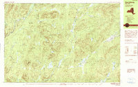
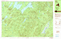
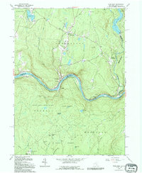
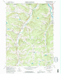
(137)- 1990 Map of Hope Falls
 1990 Hope Falls1990 Print · USGSThe Adirondack foothills of Saratoga and Hamilton Counties are shown here during the late twentieth century as the region balanced wilderness and remote settlement. Researchers can trace historic hamlets like Hope Falls and Tennantville or follow the shoreline of Great Sacandaga Lake past West Day.
 - 1990 Map of Bakers Mills
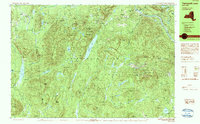
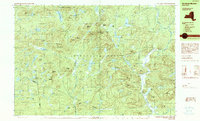
 1990 Bakers Mills1990 Print · USGSThe Adirondack wilderness of the late eighties and early nineties reveals a complex landscape of high peaks and isolated settlements. Researchers can locate remote forest sites like Grave, the clearing at Oregon, and water features including Garnet Lake and the Siamese Ponds.
 - 1990 Map of Little Tupper Lake
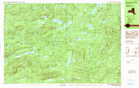
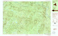
 1990 Little Tupper Lake1990 Print · USGSAdirondack wilderness in the 1990s reveals a landscape of massive lakes and isolated outposts across Hamilton and St. Lawrence counties. Trace the remote settlement of Sabattis, the facility at Whitney Headquarters, or the old route of Robinson Rd.
 - 1990 Map of Page Mountain
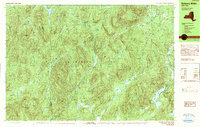
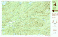
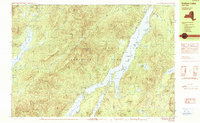
 1990 Page Mountain1990 Print · USGSThe village of Speculator and the surrounding Adirondack wilderness appear here in the late twentieth century. Outdoor historians can trace old clearings like Indian Clearing and Perkins Clearing or find natural landmarks such as Austin Falls.
 - 1990 Map of Piseco Lake
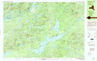
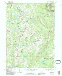
 1990 Piseco Lake1990 Print · USGSHamilton County's mountain wilderness and quiet lakefront communities are captured here in the 1990s. Genealogists and researchers can trace the small settlements of Piseco and Rudeston alongside landmarks like Higgins Bay and the local Cem.2 unique versions available
 - 1990 Map of Harrisburg
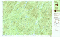
 1990 Harrisburg1990 Print · USGSThe Adirondack backcountry near the Warren and Hamilton county lines is shown here in the 1990s as a landscape of isolated hamlets and mountain lakes. Researchers can trace the layout of small settlements like Harrisburg, Griffin, and Bakertown or locate remote water bodies including Wilcox Lake and Lens Lake.
 - 1990 Map of Thirteenth Lake
 1990 Thirteenth Lake1990 Print · USGSThe Adirondack wilderness in the late twentieth century is preserved here through a dense network of peaks and high-country ponds. Genealogists and hikers can trace historic access routes like Old Farm Road or locate family-named landmarks including Edwards Hill and John Pond.2 unique versions available
 - 1990 Map of West Canada Lakes
 1990 West Canada Lakes1990 Print · USGSHamilton County's interior wilderness is captured here in the late twentieth century, showing the remote township lines of Arietta and Morehouse. Researchers can trace the network of back-country camps and water routes, from Millers Camp to the expansive Cedar Lakes and the headwaters of West Canada Creek.2 unique versions available
 - 1990 Map of Wakely Mountain
 1990 Wakely Mountain1990 Print · USGSHamilton County remains a high wilderness in the 1990s, defined by its complex river systems and private woodland retreats. Researchers can trace the headwaters of the Moose River and identify landmarks like Wakely Mountain and the Kamp Kill Kare estate.2 unique versions available
 - 1990 Map of Wells
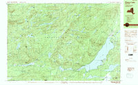
 1990 Wells1990 Print · USGSThe Adirondack wilderness around Speculator and Wells is shown here in the late twentieth century. Researchers can trace the development of Lake Algonquin and find local landmarks like Camp of the Woods and the Snowmobile Trail.2 unique versions available
 - 1990 Map of Morehouse Mountain
 1990 Morehouse Mountain1990 Print · USGSThe Adirondack wilderness of Hamilton, Herkimer, and Fulton counties is shown here in the late twentieth century. Researchers can trace the legacy of mountain life and prospecting through landmarks like Big Goldmine Hill, Powley Place, and Clockmill Corners.
 - 1990 Map of Three Ponds Mountain
 1990 Three Ponds Mountain1990 Print · USGSThe Adirondack wilderness in the early nineties is a landscape of high peaks and scattered outposts in Hamilton County. Genealogists and hikers can trace the paths near Upper Benson, the riverside at Whitehouse, and the historic Hell Devil Dam (Site).2 unique versions available
 - 1990 Map of Piercefield
 1990 Piercefield1990 Print · USGSPiercefield and the surrounding Adirondack wilderness are captured here in the early 1990s as the region maintained its quiet North Country character. Genealogists and hikers can trace old pathways around Conifer, the waters of Eagle Crag Lake, and the summit at Arab Mountain.2 unique versions available
 - 1990 Map of Indian Lake
 1990 Indian Lake1990 Print · USGSHamilton County's interior wilderness is captured here in the 1990s, centering on the expansive waters of Indian Lake. Local historians and hikers can locate the Indian Lake Fire Tower, trace the shoreline of Lewey Lake, and identify campsites around Sabael.
 - 1992 Map of Elmira, 1993 Print
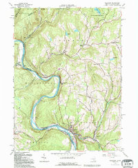
 1992 Elmira1993 Print · USGSThe Finger Lakes and Southern Tier regions are captured in the early nineties as industrial hubs like Elmira and Endicott thrived alongside university life in Ithaca. Genealogists and researchers can trace the CONRAIL rail corridors, family hilltops such as Hornby Hill, and the extensive Newtown Battlefield Reservation.
 - 1992 Map of Pond Eddy, 1994 Print
 1992 Pond Eddy1994 Print · USGSAlong the winding border of New York and Pennsylvania in the 1990s, this area shows a landscape of river-bend settlements and state forests. Genealogists can locate Pond Eddy and Glen Spey, or trace family sites at Hillside Cem and Sacred Heart Ch.
 - 1992 Map of Port Jervis North, 1994 Print
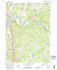
 1992 Port Jervis North1994 Print · USGSThe tri-state border region comes alive in this late twentieth-century study of the confluence of the Delaware and Neversink Rivers. Researchers can trace the path of the Erie Lackawanna railroad or locate family sites at Paradise Cem and the village of Sparrow Bush.
 - 1992 Map of Callicoon, 1994 Print
 1992 Callicoon1994 Print · USGSThe Upper Delaware River valley of New York and Pennsylvania is captured here in the early nineties, showing a landscape defined by river bends and high ridges. Genealogists can trace family roots through Holy Cross Cem, the streets of Hortonville, and the grounds of St Josephs Seminary.
 - 1992 Map of Long Eddy, 1995 Print
 1992 Long Eddy1995 Print · USGSAlong the Delaware River border in the early nineties, these valley and upland communities reflect a landscape defined by timber, stone, and recreation. Researchers can trace the layout of Equinunk, Long Eddy, and Pine Mill, or locate Union Church and Duck Harbor Pond.
 - 1992 Map of Great Bend, 1995 Print
 1992 Great Bend1995 Print · USGSSusquehanna County at the New York border shows a landscape of river loops and ridges in the early 1990s. Local researchers can locate family sites near Brushville, Hickory Grove, and Highland Cem or trace the Conrail line through Hallstead.
 - 1992 Map of Laurel Lake, 1995 Print
 1992 Laurel Lake1995 Print · USGSSusquehanna County highland life at the New York border is preserved here, showing a landscape defined by glacial waters and rural industry. Trace family roots at St Augustine Ch or Brackney Cem, and locate old landmarks like Fisk Mill and Silver Lake.
 - 1992 Map of Franklin Forks, 1995 Print
 1992 Franklin Forks1995 Print · USGSSusquehanna County near the New York border shows a landscape of small farming hamlets and active stone extraction in the mid-1990s. Genealogists and local researchers can locate Franklin Forks, Mountain Valley Cem, and the rural crossroads of Upsonville.
 - 1992 Map of Lake Como, 1995 Print
 1992 Lake Como1995 Print · USGSWayne County's lake country is captured here in the early 1990s, showing a landscape of seasonal camps and rural crossroads. Researchers can locate St Julianas Cem at Church Hill or trace the Old Railroad Grade near Dillontown.
 - 1992 Map of Hancock, 1995 Print
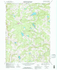
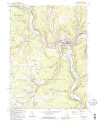 1992 Hancock1995 Print · USGSThe confluence of the Delaware River branches at the New York and Pennsylvania border highlights a landscape of river-town industry and highland lakes. Researchers can trace the rail lines through Hancock, locate family sites at Kingsbury Hill Cem, and explore the rural character of Starlight.2 unique versions available
 - 1993 Map of Waterbury
 1993 Waterbury1993 Print · USGSWestern Connecticut and the Hudson Valley appear in the early nineties as a landscape of established industrial cities and deep forest preserves. Researchers can trace the rail corridors of the Metro-North Railroad or locate family sites near the Taft School and Riverside Cemetery.
Showing maps 1-25 of 137
Top cities of New York
- New York historical maps
- Hempstead historical maps
- Brookhaven historical maps
- Islip historical maps
- Oyster Bay historical maps
- Buffalo historical maps
See more
Top counties of New York
- Kings County historical maps
- Queens County historical maps
- New York County historical maps
- Suffolk County historical maps
- Bronx County historical maps
- Nassau County historical maps
See more
Frequently asked questions
- What are the different types of historical maps available for New York?
- What is the oldest map of New York?
- Where can I purchase historical maps of New York for my home or office?
- Where can I download high-res historical maps of New York?
- Are there historical topographic maps available for New York?
- Is there historical aerial imagery available for New York?
- Where are historical maps of New York sourced from?