1920s Maps of Ohio
Explore 24 historic maps of Ohio from the 1920s. These maps offer a rare glimpse into what life looked like during the 1920s — showing old roads, neighborhoods, homes, and landmarks that have changed or disappeared over time.
Whether you're researching your family's past, planning a metal detecting trip, or studying how Ohio's landscape evolved across the 1920s, these high-resolution maps are a powerful tool for exploring the history of this region.
- Focus on a specific era: All maps on this page are from the 1920s, giving you a focused view of this time period.
- See what’s changed: Compare century-old streets, trails, and buildings to today's modern landscape using overlays and satellite layers.
- Research with precision: Use these maps for genealogy, historical research, land use analysis, or educational projects.
- View, download, or print: Maps are fully viewable online in high resolution, and can be downloaded or printed for your own records.
Start exploring Ohio's history through authentic maps from the 1920s. This is your window into the past.
Ohio maps
(24)- 1923 Map of West Columbus, 1955 Print
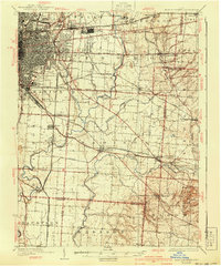
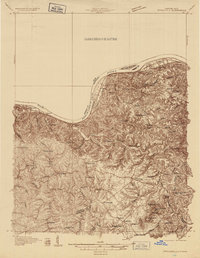
 1923 West Columbus1955 Print · USGSFranklin County in the early twenties shows the growing western edge of Columbus and its surrounding rural townships. Genealogists and historians can trace the paths of the National Road and find landmarks like Camp Chase, Urbancrest, and Pisgah School.
 - 1924 Map of Belleville, 1954 Print
 1924 Belleville1954 Print · USGSWood County’s riverfront settlements and rural school districts are captured here in the mid-twenties during the height of the rail era. Genealogists can locate long-lost family landmarks like Harris Ferry, Meldahl, and dozens of rural schoolhouses including Leafy Glen School.
 - 1924 Map of Delaware, 1954 Print
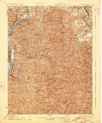
 1924 Delaware1954 Print · USGSDelaware and its surrounding townships thrive in the mid-twenties as vital rail and river hubs. Researchers can trace the heritage of rural communities through dozens of local landmarks like Cherry Ridge School, Bethlehem Church, and Warrensburg.
 - 1924 Map of St Marys, 1956 Print
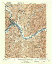
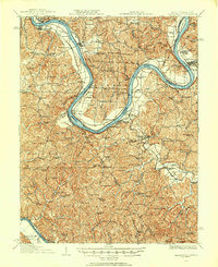
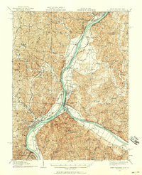
 1924 St Marys1956 Print · USGSPleasants County and the Ohio River valley are shown here in the mid-twenties, just as the local rail and river networks reached their peak. Genealogists can trace hundreds of family sites near St Marys, including Bibbys Chapel, Ellenboro, and the Willow Island School.
 - 1924 Map of New Martinsville, 1956 Print
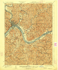
 1924 New Martinsville1956 Print · USGSThe Ohio River valley in the early twenties reveals a landscape of busy rail corridors and riverfront towns. Genealogists can locate family names and rural landmarks from Winders Mill to dozens of country schoolhouses like Democracy School and Wayne School.2 unique versions available
 - 1924 Map of New Matamoras, 1958 Print
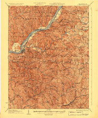
 1924 New Matamoras1958 Print · USGSThe Ohio River borderlands are shown in detail during the mid-1920s, featuring the winding valleys of the Muskingum rivers. Genealogists can trace family locations through named schools and rural post offices like Rinard Mills, Salem Hall, and Zion Church.
 - 1924 Map of Marietta, 1962 Print
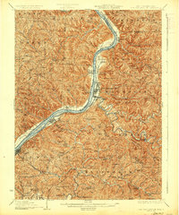
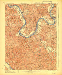
 1924 Marietta1962 Print · USGSThe Ohio River borderlands near the Muskingum confluence are captured here in the 1920s, showing a landscape of river-bend towns and hilltop farmsteads. Researchers can trace historic schools and rural meeting places like Rising Sun School, Social Chapel, and the Baltimore and Ohio RR line.
 - 1925 Map of East Columbus, 1940 Print
 1925 East Columbus1940 Print · USGSGreater Columbus and its eastern suburbs were rapidly expanding in the 1920s as industry and transit lines bridged the gap between city and farm. Genealogists and historians can trace the paths of the ABANDONED CANAL, the legacy of NORTON FIELD, and old village centers like Canal Winchester and Lithopolis.3 unique versions available
 - 1925 Map of Delaware, 1940 Print
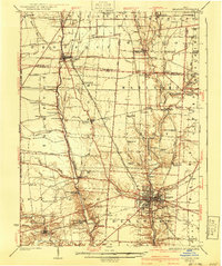 1925 Delaware1940 Print · USGSCentral Ohio in the mid-1920s is defined by its vibrant river valleys and shifting rail corridors. Genealogists can trace family roots through numerous country schools like Schoor School, rural parishes such as St James Church, and early settlements like Ostrander and Radnor.
 - 1925 Map of West Columbus, 1946 Print
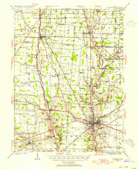
 1925 West Columbus1946 Print · USGSFranklin and Pickaway counties are shown here in the mid-twenties, when the growing state capital met a landscape of electric railways and rural schoolhouses. Researchers can trace the National Road and locate sites like the Pisgah School, Mt Calvary Cemetery, and the State Hospital.
 - 1926 Map of Greenup
 1926 Greenup1926 Print · USGSGreenup County in the mid-1920s is a landscape of riverfront rail towns and a high density of rural schoolhouses tucked into the Kentucky hollows. Genealogists and historians can trace family locations near Old Steam Furnace School, Nonchalanta, and Taylor Sta McCall PO.3 unique versions available
 - 1926 Map of Ravenswood
 1926 Ravenswood1926 Print · USGSThe Ohio River valley in the mid-1920s reveals a landscape of tight river bends and bustling waterfront towns like Ravenswood and Hartford. Researchers can trace the early rail network of the Baltimore and Ohio and locate numerous rural landmarks such as Jackson Chapel and the Mountain Flower School.
 - 1926 Map of Belleville
 1926 Belleville1926 Print · USGSThe Ohio River valley and its rugged Wood County hinterlands come into focus in the mid-twenties. Genealogists and historians can locate dozens of rural schools and churches like Leafy Glen School, Torch PO, and Serepta Church along the winding runs.2 unique versions available
 - 1926 Map of New Martinsville
 1926 New Martinsville1926 Print · USGSThe Ohio River valley in the mid-1920s reveals a bustling corridor of rail and river commerce connecting New Martinsville and Sistersville. Genealogists can trace hundreds of rural landmarks, from the County Infirmary to isolated hill schools like Rothlisberger School and Sugar Valley School.2 unique versions available
 - 1926 Map of New Matamoras
 1926 New Matamoras1926 Print · USGSThe Ohio River valley and the rugged interior of Monroe County appear here in the mid-1920s. Genealogists can trace early twentieth-century rural life through numerous small post offices and schools like Cochransville Centerview PO and Excelsior School.2 unique versions available
 - 1926 Map of Point Pleasant, 1958 Print
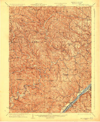
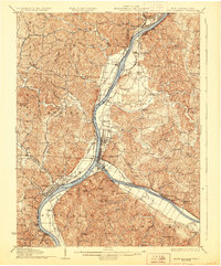
 1926 Point Pleasant1958 Print · USGSAt the meeting of the Ohio and Kanawha rivers, this 1920s landscape captures a bustling network of river commerce and railroad towns. Researchers can trace historic river crossings like the Gallipolis Ferry and locate early institutional landmarks including the Epileptic Home and State Industrial School.
 - 1927 Map of Marietta
 1927 Marietta1927 Print · USGSThe Mid-Ohio Valley comes alive in this mid-1920s survey of the river confluence at the Ohio River. Genealogists can trace family roots through numerous country schools and churches like Last Chance School and Shiloh Church.3 unique versions available
 - 1927 Map of Saint Marys
 1927 Saint Marys1927 Print · USGSPleasants and Ritchie counties come into focus during the mid-twenties as the Baltimore and Ohio railroad skirts the Ohio River. Researchers can trace ancestral locations through dozens of rural landmarks, from the Northwestern Turnpike to the Willow Island School and Mt Carmel Church.3 unique versions available
 - 1928 Map of Ravenswood
 1928 Ravenswood1928 Print · USGSThe Ohio River's great winding oxbows dominate the landscape in the late twenties, anchoring a world of river-town commerce and hilltop farming. Genealogists can trace hundreds of family-named landmarks, from the Mountain Flower School to the Antioch Church and the rails of the Baltimore & Ohio RR.3 unique versions available
 - 1928 Map of Higginsport
 1928 Higginsport1928 Print · USGSThe Kentucky side of the Ohio River is captured in the late twenties just as the rail-and-river economy flourished. Researchers can trace the riverbank rail lines of the Chesapeake and Ohio or locate early rural landmarks like Locust Grove Sch and the town of Augusta.
 - 1928 Map of Lawrenceburg, 1962 Print
 1928 Lawrenceburg1962 Print · USGSThe tri-state river valley at the end of the Roaring Twenties shows a landscape shaped by the Ohio River and bustling rail junctions. Researchers can trace historic ferries like the Lawrenceburg Ferry and find family-named landmarks like Commissary Corner or the Bullittsburg Ch.
 - 1929 Map of Springdale
 1929 Springdale1929 Print · USGSThe Ohio River valley and Kentucky's northern hills are captured here in the late twenties, showing a landscape defined by the Chesapeake and Ohio railroad. Genealogists can trace early homesteads and landmarks near Tollesboro, Ruggles Camp, and the many rural sites like Ebenezer Ch.2 unique versions available
 - 1929 Map of Point Pleasant
 1929 Point Pleasant1929 Print · USGSThe riverfronts of the Ohio and Kanawha serve as the industrial spine for this region during the late 1920s. Researchers can trace genealogical roots through dozens of local landmarks like Ambrosia PO, Clipper Mill, and the Morning Star School.2 unique versions available
 - 1929 Map of Alexandria
 1929 Alexandria1929 Print · USGSNorthern Kentucky and the Ohio River border appear here in the late twenties as a bustling landscape of ridge-top farms and river-valley rail towns. Genealogists can trace family roots through numerous local landmarks like Oak Island Ch, Grants Lick, and the many rural schools such as Carthage Sch.
End of results
Showing maps 1-24 of 24
Top cities of Ohio
- Columbus historical maps
- Cleveland historical maps
- Cincinnati historical maps
- Toledo historical maps
- Akron historical maps
- Dayton historical maps
See more
Top counties of Ohio
- Cuyahoga County historical maps
- Franklin County historical maps
- Hamilton County historical maps
- Summit County historical maps
- Montgomery County historical maps
- Lucas County historical maps
See more
Frequently asked questions
- What are the different types of historical maps available for Ohio?
- What is the oldest map of Ohio?
- Where can I purchase historical maps of Ohio for my home or office?
- Where can I download high-res historical maps of Ohio?
- Are there historical topographic maps available for Ohio?
- Is there historical aerial imagery available for Ohio?
- Where are historical maps of Ohio sourced from?