1980s Maps of Pennsylvania
Explore 45 historic maps of Pennsylvania from the 1980s. These maps offer a rare glimpse into what life looked like during the 1980s — showing old roads, neighborhoods, homes, and landmarks that have changed or disappeared over time.
Whether you're researching your family's past, planning a metal detecting trip, or studying how Pennsylvania's landscape evolved across the 1980s, these high-resolution maps are a powerful tool for exploring the history of this region.
- Focus on a specific era: All maps on this page are from the 1980s, giving you a focused view of this time period.
- See what’s changed: Compare century-old streets, trails, and buildings to today's modern landscape using overlays and satellite layers.
- Research with precision: Use these maps for genealogy, historical research, land use analysis, or educational projects.
- View, download, or print: Maps are fully viewable online in high resolution, and can be downloaded or printed for your own records.
Start exploring Pennsylvania's history through authentic maps from the 1980s. This is your window into the past.
Pennsylvania maps
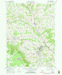
(45)- 1980 Map of Bradford, 1982 Print
 1980 Bradford1982 Print · USGSNorthern Pennsylvania's oil country and deep forests are captured here during the 1980s. Genealogists and researchers can trace rail-side settlements like Kushequa, Gifford, and Lewis Run or locate specific Oil and Gas Field sites across the plateau.
 - 1981 Map of Cumberland, 1982 Print
 1981 Cumberland1982 Print · USGSThe tri-state region of Maryland, Pennsylvania, and West Virginia is captured here in the early eighties as a landscape of industrial history and ridgeline geography. Researchers can trace the heritage of the C & O Canal and the B & O RR through mountain gaps and coal towns like Eckhart Mines and Frostburg.2 unique versions available
 - 1981 Map of Towanda, 1982 Print
 1981 Towanda1982 Print · USGSThe Susquehanna Valley at the turn of the 1980s reveals a region of mountain forests and busy river towns along the New York border. Researchers can trace the legacy of the CONRAIL lines through Sayre or locate remote landmarks like Armenia Mountain and Mt Pisgah State Park.
 - 1981 Map of Wellsboro, 1982 Print
 1981 Wellsboro1982 Print · USGSNorthern Pennsylvania in the early eighties shows a landscape of deep river gorges and vast state forests. Trace the rail lines of Conrail and explore old settlements from Coudersport to the Pine Creek Gorge.
 - 1981 Map of Johnstown, 1983 Print
 1981 Johnstown1983 Print · USGSSouth Central Pennsylvania is captured here in the early eighties, from the industrial heart of the Conemaugh Valley to the ridges of the Allegheny Front. Local historians can trace the rail corridors of Conrail and the growth of mountain communities like Ebensburg, Nanty Glo, and Windber.
 - 1982 Map of Trenton, 1983 Print
 1982 Trenton1983 Print · USGSCentral New Jersey and the Delaware River valley are captured in the early eighties during a time of major highway expansion and suburban maturation. Researchers can trace the grounds of Princeton University, the historic Monmouth Battlefield, and the sprawling Fort Dix.
 - 1983 Map of Indiana
 1983 Indiana1983 Print · USGSWestern Pennsylvania in the early eighties shows a landscape of industrial river towns and expanding university campuses. Genealogists can trace family roots through Lucernemines and Spring Church, or locate ancestors in Oakland Cemetery.
 - 1983 Map of Clearfield, 1984 Print
 1983 Clearfield1984 Print · USGSPennsylvania's coal and timber heartland is captured in the early eighties as industrial hubs like Du Bois and Saint Marys thrived among the state forests. Genealogists can locate family landmarks like Morningside Cemetery, the old works at Dagus Mines, and the rural community of Byrnedale.
 - 1983 Map of Oil City, 1984 Print
 1983 Oil City1984 Print · USGSThe Allegheny and Clarion river valleys are shown in the early eighties as a hub of rail lines and conservation lands. Genealogists can trace family connections in Oil City and Franklin or locate rural sites like the Pennsylvania State Hospital and School and Coal City.
 - 1983 Map of York, 1984 Print
 1983 York1984 Print · USGSSouth Central Pennsylvania and Northern Maryland meet along the Susquehanna during the early eighties. Genealogists and local historians can trace the transit networks of Conrail and Amtrak through towns like Red Lion and Seven Valleys.2 unique versions available
 - 1983 Map of Hagerstown, 1984 Print
 1983 Hagerstown1984 Print · USGSThe tri-state borderlands of Maryland, Pennsylvania, and West Virginia are shown in the early eighties as a hub of military installations and valley towns. Genealogists and historians can trace the landscape from Gettysburg National Military Park to the banks of the Potomac River.2 unique versions available
 - 1983 Map of Warren, 1984 Print
 1983 Warren1984 Print · USGSNorthwestern Pennsylvania at the dawn of the 1980s reveals a landscape defined by the petroleum industry and expansive public lands. Trace the legacy of early oil at Drake Well Memorial Park and Pithole City Historical Site, or locate family sites near Warren State Hospital and Kellettville.
 - 1983 Map of Troy, 1991 Print
 1983 Troy1991 Print · USGSTroy and the surrounding Bradford County uplands are documented here in the early 1980s. Researchers can trace the Penn Central rail line and locate numerous family-named burial sites like Chase-Newbury Cem and Glenwood Cem.
 - 1984 Map of Moundsville
 1984 Moundsville1984 Print · USGSThe Ohio River valley and the Appalachian interior meet in the mid-eighties as a hub of rail and river commerce. Genealogists and historians can trace the development of river towns like New Martinsville, inland hubs like Waynesburg, and the path of the B & O RR.
 - 1984 Map of Allentown, 1985 Print
 1984 Allentown1985 Print · USGSThe Lehigh Valley and southern Poconos are captured in the mid-eighties as industry and academic life converge along the river corridor. Trace the rail-and-water networks connecting Jim Thorpe and Bethlehem, or explore landmarks like Lehigh University and the Delaware Water Gap.3 unique versions available
 - 1984 Map of Harrisburg, 1985 Print
 1984 Harrisburg1985 Print · USGSCentral Pennsylvania in the mid-eighties shows a landscape defined by the winding Susquehanna River and the industrial growth of its river towns. Researchers can trace the rail corridors of Amtrak and Conrail or explore the bounds of Fort Indiantown Gap Military Reservation.2 unique versions available
 - 1984 Map of Tyrone, 1985 Print
 1984 Tyrone1985 Print · USGSCentral Pennsylvania in the mid-eighties shows a rugged landscape defined by the industry of Altoona and the ridges of the Appalachians. Genealogists and historians can trace the rail corridors of CONRAIL and locate vanished family homes near Glendale Lake or within Sinking Valley.
 - 1984 Map of Williamsport East, 1985 Print
 1984 Williamsport East1985 Print · USGSThe Susquehanna River valley and Allegheny highlands come together in this mid-eighties survey of central Pennsylvania. Trace family roots at Muncy Cem or locate institutional landmarks like Lycoming College and the State Correctional Institution at Retreat.2 unique versions available
 - 1984 Map of Carlisle, 1985 Print
 1984 Carlisle1985 Print · USGSSouth-central Pennsylvania is shown during the mid-eighties as a hub of military activity and mountain transit. Genealogists and historians can trace the development of Carlisle Barracks and Letterkenny Army Depot, alongside rail routes like Conrail.2 unique versions available
 - 1984 Map of State College, 1985 Print
 1984 State College1985 Print · USGSCentral Pennsylvania’s Ridge-and-Valley province is captured here in the mid-eighties, showing the deep connection between the mountain terrain and the region's historic settlements. Researchers can trace the layout of Pennsylvania State University and follow old rail corridors like the Bellefonte Historical RR and Conrail.
 - 1984 Map of Williamsport West, 1985 Print
 1984 Williamsport West1985 Print · USGSCentral Pennsylvania in the mid-eighties was a landscape of dense state forests and industrious river towns along the West Branch Susquehanna River. Trace the rail lines of Conrail through Renovo or locate the historic grounds of Lock Haven State College.2 unique versions available
 - 1984 Map of Sunbury, 1985 Print
 1984 Sunbury1985 Print · USGSPennsylvania coal country and the Susquehanna valley appear here in the early eighties, showcasing a landscape defined by industrial ridges and river towns. Genealogists and historians can trace rail corridors like Conrail and explore mountain settlements from Mahanoy City to Elizabethville.2 unique versions available
 - 1984 Map of Wilmington, 1986 Print
 1984 Wilmington1986 Print · USGSThe Delaware Valley in the mid-eighties was a powerhouse of transit and industry where Delaware, New Jersey, Pennsylvania, and Maryland meet. Researchers can trace the sprawling rail networks of SEPTA and PATCO or locate historic sites like Fort Delaware State Park and Valley Forge State Forest.2 unique versions available
 - 1984 Map of Reading, 1986 Print
 1984 Reading1986 Print · USGSSoutheastern Pennsylvania in the mid-eighties shows a landscape of established industrial hubs and rapid suburban expansion. Trace local history through landmarks like Valley Forge National Historical Park, the Willow Grove Naval Air Station, and Kutztown University.2 unique versions available
 - 1985 Map of Erie, 1986 Print
 1985 Erie1986 Print · USGSThe Pennsylvania lakefront and the city of Erie are documented here in the mid-eighties, highlighting the region's transition from industrial hub to regional center. Genealogists and researchers can trace the neighborhoods of Wesleyville and Lake City or locate landmarks like Waldameer Park and the Conrail lines.
Showing maps 1-25 of 45
Top cities of Pennsylvania
- Philadelphia historical maps
- Pittsburgh historical maps
- Allentown historical maps
- Erie historical maps
- Reading historical maps
- Upper Darby historical maps
See more
Top counties of Pennsylvania
- Philadelphia County historical maps
- Allegheny County historical maps
- Montgomery County historical maps
- Bucks County historical maps
- Delaware County historical maps
- Chester County historical maps
See more
Frequently asked questions
- What are the different types of historical maps available for Pennsylvania?
- What is the oldest map of Pennsylvania?
- Where can I purchase historical maps of Pennsylvania for my home or office?
- Where can I download high-res historical maps of Pennsylvania?
- Are there historical topographic maps available for Pennsylvania?
- Is there historical aerial imagery available for Pennsylvania?
- Where are historical maps of Pennsylvania sourced from?