1910s Maps of Pennsylvania
Explore 40 historic maps of Pennsylvania from the 1910s. These maps offer a rare glimpse into what life looked like during the 1910s — showing old roads, neighborhoods, homes, and landmarks that have changed or disappeared over time.
Whether you're researching your family's past, planning a metal detecting trip, or studying how Pennsylvania's landscape evolved across the 1910s, these high-resolution maps are a powerful tool for exploring the history of this region.
- Focus on a specific era: All maps on this page are from the 1910s, giving you a focused view of this time period.
- See what’s changed: Compare century-old streets, trails, and buildings to today's modern landscape using overlays and satellite layers.
- Research with precision: Use these maps for genealogy, historical research, land use analysis, or educational projects.
- View, download, or print: Maps are fully viewable online in high resolution, and can be downloaded or printed for your own records.
Start exploring Pennsylvania's history through authentic maps from the 1910s. This is your window into the past.
Pennsylvania maps
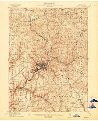
(40)- 1910 Map of New Kensington
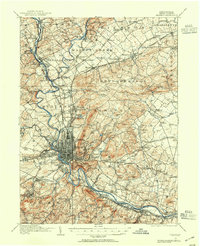
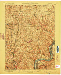 1910 New Kensington1910 Print · USGSThe industrial Allegheny River corridor and its rugged hinterlands come alive in this 1910 survey of the Westmoreland and Butler County borders. Genealogists and historians can trace family roots through labels for Sandy Hill School, Clinton Church, and the settlement at Saxonburg.7 unique versions available
 - 1910 Map of York
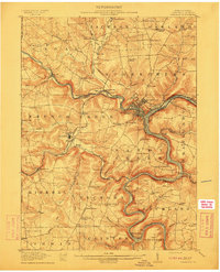
 1910 York1910 Print · USGSYork County at the turn of the century reveals a landscape shaped by rail expansion and deep-rooted rural industry. Genealogists and historians can trace family-named sites like Sechrist Mill, Klein School, and Hopewell Church along the winding Maryland & Pennsylvania RR.6 unique versions available
 - 1910 Map of Zelienople
 1910 Zelienople1910 Print · USGSWestern Pennsylvania in the early twentieth century is a landscape of thriving creek-side towns and intersecting rail lines. Genealogists can trace family roots through numerous rural landmarks like McConnells Mill, Zion Church, and the many country schoolhouses including American School.5 unique versions available
 - 1910 Map of Bedford
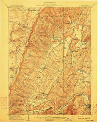 1910 Bedford1910 Print · USGSBedford County's agrarian valleys and mountain ridges are captured here during the peak of the rural schoolhouse era. Researchers can trace ancestral locations at Weyant PO, Schellsburg, and Mowrys Mills, or locate early landmarks like Eight Square School.4 unique versions available
 - 1910 Map of Hilliards, 1956 Print
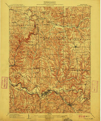
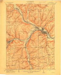
 1910 Hilliards1956 Print · USGSButler and Venango Counties come into focus during this early twentieth-century survey of western Pennsylvania's hill country. Researchers can trace the era's rural infrastructure through dozens of sites like Mechanicsville Wesley PO, Rankin Church, and the Boyer's Annandale Sta.
 - 1910 Map of Paw Paw, 1959 Print
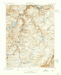
 1910 Paw Paw1959 Print · USGSMaryland and West Virginia meet along the serpentine Potomac River in the early twentieth century as railroads and canals compete for the valley. Trace the industrial landscape from the Ohio and Chesapeake Canal to the river towns of Paw Paw and Little Orleans.
 - 1911 Map of Franklin
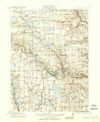
 1911 Franklin1911 Print · USGSVenango County at the peak of the rail era shows the busy confluence of the Allegheny River and French Creek. Trace the legacy of early industrial settlements like Coal City, family landmarks at McKenzie Cors, and the grounds of the State Institute for Feeble Minded.4 unique versions available
 - 1911 Map of Taneytown
 1911 Taneytown1911 Print · USGSCarroll County and the Maryland-Pennsylvania borderlands are captured here just after the turn of the century, showing a network of rail-linked towns and water-powered mills. Trace local history through Taneytown, Union Mills, and Pipe Creek Church, or find early school sites like Centennial Hall School.6 unique versions available
 - 1911 Map of Hamburg
 1911 Hamburg1911 Print · USGSBerks and Schuylkill counties are captured here at a peak of rail-driven rural life just before the Great War. Researchers can trace family roots through specific locales like New Ringgold, Dorset Sta, and the historic Five Locks along the Schuylkill River.5 unique versions available
 - 1911 Map of Emmitsburg
 1911 Emmitsburg1911 Print · USGSMaryland's northern borderlands and the Catoctin mountains thrived in the early twentieth century as a hub for institutions, railroads, and milling. Genealogists and historians can locate family homes and old crossroads near St Josephs Academy, Sabillasville, and the Western Maryland RR.6 unique versions available
 - 1911 Map of Butler
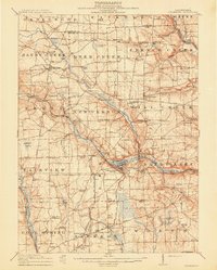
 1911 Butler1911 Print · USGSButler emerges as a bustling rail and trolley hub during the first decade of the twentieth century. Genealogists and local historians can trace the paths of the Pittsburg and Butler Electric Railway or locate family homesteads near Frazier Mill and White Church.5 unique versions available
 - 1911 Map of Stoneboro, 1960 Print
 1911 Stoneboro1960 Print · USGSMercer County at the height of its rural rail era was a dense network of farming hamlets and local schools. Genealogists can trace family names at Williams Corners, find many one-room schools like Ross School, or locate the hamlet of Fiddlers Green.
 - 1912 Map of Quarryville
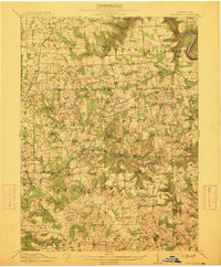
 1912 Quarryville1912 Print · USGSLancaster County's agrarian and industrial character is frozen in time here, shortly after the 1910 survey. Researchers can trace the heavy influence of the rail network through Nickel Mines or locate rural landmarks like Wheatland Mills and Mechanic Grove.6 unique versions available
 - 1912 Map of Hagerstown
 1912 Hagerstown1912 Print · USGSMaryland's Cumberland Valley flourished as a rail and milling corridor during the early twentieth century. Genealogists can trace family names across dozens of rural landmarks like Strites Mill, Hallowell Church, and the Paradise School.9 unique versions available
 - 1912 Map of Hilliards
 1912 Hilliards1912 Print · USGSButler and Venango Counties at the height of the rail era are shown here in intricate detail. Genealogists can trace family names across dozens of rural institutions, from Wesley PO and Sutton Mill to the remote Whiskerville.4 unique versions available
 - 1912 Map of Williamsport
 1912 Williamsport1912 Print · USGSUpper Maryland and the West Virginia panhandle were bustling centers of river and rail transit before the First World War. Researchers can trace the path of the Chesapeake and Ohio Canal and locate family landmarks like Cushwa Mill or the St James School.3 unique versions available
 - 1912 Map of Mc Calls Ferry
 1912 Mc Calls Ferry1912 Print · USGSThe Susquehanna River valley near Safe Harbor is caught at a peak of rail-and-mill development during this pre-war survey. Genealogists and historians can trace the foundations of Martic Forge, find remote country schools like Red Hill School, and locate old stops on the Pennsylvania RR.5 unique versions available
 - 1913 Map of Stoneboro
 1913 Stoneboro1913 Print · USGSMercer County at the turn of the century shows a landscape of river-valley agriculture and developing rail lines. Researchers can trace family history through dozens of rural schools like Pike School and settlements such as Sheakleyville or Fiddlers Green.5 unique versions available
 - 1913 Map of Mercer
 1913 Mercer1913 Print · USGSMercer and Grove City anchor this early twentieth-century landscape during a period of coal mining and railway expansion. Genealogists can trace family roots through numerous local schools like Bottle Hill School and rural settlements such as Pardoe and Amsterdam.6 unique versions available
 - 1913 Map of Reading, 1954 Print
 1913 Reading1954 Print · USGSThe Schuylkill valley near the turn of the century shows a landscape transitioning between its colonial iron roots and a modern rail-driven economy. Genealogists and historians can trace family locations near the Friends Meetinghouse, Van Reeds Mill, or the many district schoolhouses like Neff School.
 - 1913 Map of Milford, 1958 Print
 1913 Milford1958 Print · USGSBefore the Tri-State area was suburbanized, this early twentieth-century survey captures the rugged river economy of the Delaware valley. Genealogists can trace family roots at McCartys Corner or locate vanished rural schoolhouses like the McCain School and Woodtown School.
 - 1913 Map of Somerset, 1961 Print
 1913 Somerset1961 Print · USGSSomerset County was a rugged crossroads of rail and mountain ridges in the decade before the First World War. Local historians can trace the Pittsburgh and Philadelphia Road and find vanished local landmarks like Rectors Mill, the Quemahoning Tunnel, and Sipesville Station.
 - 1913 Map of North East, 1962 Print
 1913 North East1962 Print · USGSThe Lake Erie shoreline and the Pennsylvania-New York border come alive in this survey of the pre-war lakefront and interior. Genealogists can locate dozens of early district schools and family landmarks like Colts Station, Lowville, and the McCord School.
 - 1914 Map of Corning
 1914 Corning1914 Print · USGSSteuben County is a thriving rail and river hub during the early twentieth century, centered on the strategic confluence at Painted Post. Genealogists and local historians can locate dozens of neighborhood landmarks, including French's Mill, Lumber City School, and the remote Liberty Pole School.6 unique versions available
 - 1914 Map of Windber, 1955 Print
 1914 Windber1955 Print · USGSSomerset County coal and rail towns thrive along the Allegheny front during the height of the early industrial era. Genealogists and historians can trace the foundations of Windber, locate the Old Shade Furnace, and map family-named schools like Keafer School.3 unique versions available
Showing maps 1-25 of 40
Top cities of Pennsylvania
- Philadelphia historical maps
- Pittsburgh historical maps
- Allentown historical maps
- Erie historical maps
- Reading historical maps
- Upper Darby historical maps
See more
Top counties of Pennsylvania
- Philadelphia County historical maps
- Allegheny County historical maps
- Montgomery County historical maps
- Bucks County historical maps
- Delaware County historical maps
- Chester County historical maps
See more
Frequently asked questions
- What are the different types of historical maps available for Pennsylvania?
- What is the oldest map of Pennsylvania?
- Where can I purchase historical maps of Pennsylvania for my home or office?
- Where can I download high-res historical maps of Pennsylvania?
- Are there historical topographic maps available for Pennsylvania?
- Is there historical aerial imagery available for Pennsylvania?
- Where are historical maps of Pennsylvania sourced from?