1950s Maps of Utah County, Utah
Explore 35 historic maps of Utah County from the 1950s. These maps offer a rare glimpse into what life looked like during the 1950s — showing old roads, neighborhoods, homes, and landmarks that have changed or disappeared over time.
Whether you're researching your family's past, planning a metal detecting trip, or studying how Utah County's landscape evolved across the 1950s, these high-resolution maps are a powerful tool for exploring the history of this region.
- Focus on a specific era: All maps on this page are from the 1950s, giving you a focused view of this time period.
- See what’s changed: Compare century-old streets, trails, and buildings to today's modern landscape using overlays and satellite layers.
- Research with precision: Use these maps for genealogy, historical research, land use analysis, or educational projects.
- View, download, or print: Maps are fully viewable online in high resolution, and can be downloaded or printed for your own records.
Start exploring Utah County's history through authentic maps from the 1950s. This is your window into the past.
Utah County, UT maps
(35)- 1950 Map of Orem
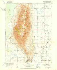
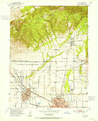
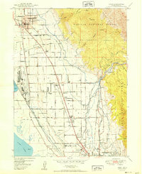 1950 Orem1950 Print · USGSIn the shadow of the Wasatch Range after the war, this area shows the heavy industrialization of the lakeshore and the complex irrigation of the benchlands. Trace the footprint of the Geneva Steel Plant, the rail lines at Orem Sta, and local landmarks like Lincoln High Sch.
 - 1950 Map of Aspen Grove
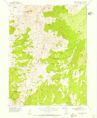
 1950 Aspen Grove1950 Print · USGSThe high Wasatch Range at the mid-point of the century shows a landscape defined by mountain recreation and education. Genealogists and historians can trace the foundations of Aspen Grove, the Alpine Summer School (B. Y. U.), and the early rail route of the Rio Grande and Western.
 - 1950 Map of Timpanogos Cave
 1950 Timpanogos Cave1950 Print · USGSThe high Wasatch Range comes into sharp focus during the mid-twentieth century, centered on the dramatic American Fork Canyon. Geologists and local historians can trace early mountain infrastructure including the Salt Lake City Aqueduct, Mutual Dell, and Timpooneke Guard Sta.
 - 1950 Map of Provo
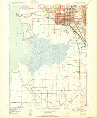 1950 Provo1950 Print · USGSProvo and the surrounding valley are captured here at a moment of significant mid-century expansion between the lake and the forest. Researchers can trace the layout of the B. Y. U. (Upper Campus), locate the City Cemetery, and find smaller settlements like Palmyra.
 - 1950 Map of Bridal Veil Falls
 1950 Bridal Veil Falls1950 Print · USGSThe Provo River canyon was a bustling corridor for the Denver & Rio Grande Western and mountain travelers in the 1950s. Trace old settlements like Vivian Park, Springdell, and the landmark Bridal Veil Falls.
 - 1950 Map of Springville
 1950 Springville1950 Print · USGSSpringville and Mapleton sit at the foot of the Wasatch Range in the 1950s, showing a transition from town life to mountain wilderness. Genealogists can locate family sites near Evergreen Cem or trace industry along the Utah Railway and Ironton.
 - 1950 Map of Spanish Fork
 1950 Spanish Fork1950 Print · USGSThe Utah Valley at mid-century shows a thriving agricultural and industrial corridor shaped by irrigation and rail. Researchers can trace family roots through the Benjamin Cem, locate old schoolhouses like Rees Sch, or find the historic Sugar Refinery.
 - 1950 Map of West Mountain, 1951 Print
 1950 West Mountain1951 Print · USGSThe foothills of the Wasatch Range meet the shores of Utah Lake in the early 1950s. Genealogists and industrial historians can trace the tracks of the Denver and Rio Grande Western through Goshen Gap to the Keigley Quarry.3 unique versions available
 - 1950 Map of Goshen Valley North, 1952 Print
 1950 Goshen Valley North1952 Print · USGSThe western shores of Utah Lake meet the Goshen Valley in the early fifties, showing a landscape of transition. Trace historical water use through the Abandoned Canal, Pinyon Creek, and early Genola Town Boundary.3 unique versions available
 - 1950 Map of Soldiers Pass, 1952 Print
 1950 Soldiers Pass1952 Print · USGSThe western shores of Utah Lake appear at mid-century, featuring the remnants of early settlement and mountain passage. Genealogists and historians can trace the Mosida (Site) area and locate industrial markers like the Mine Tunnel and Pumice Pit.3 unique versions available
 - 1950 Map of Pelican Point, 1958 Print
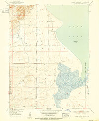
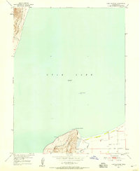
 1950 Pelican Point1958 Print · USGSThe western shores of Utah Lake and the northern outskirts of American Fork are shown here during the early fifties. Genealogists and historians can trace the paths of the Union Pacific through Wing or locate the Calcite Quarry and waterfront Pumping Sta.3 unique versions available
 - 1950 Map of Lincoln Point, 1958 Print
 1950 Lincoln Point1958 Print · USGSUtah Lake's southern shores are captured here at mid-century, showing the relationship between the rising terrain and the water. Researchers can trace the path of an Abandoned Canal and locate benchmarks near Lincoln Point and West Mountain.2 unique versions available
 - 1950 Map of West Mountain, 1959 Print
 1950 West Mountain1959 Print · USGSThe shores of Utah Lake and the industrial corridors of the southern valley come into focus during the mid-century. Genealogists and historians can trace the rail lines of the Union Pacific and locate historic sites like Mosida (Site) and the Keigley Quarry.2 unique versions available
 - 1951 Map of Spanish Fork Peak
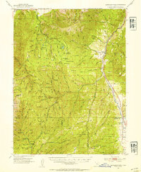
 1951 Spanish Fork Peak1951 Print · USGSThe foothills of the Wasatch Range come alive in this early 1950s record of the settlement and industry near Mapleton. Trace the path of the Denver and Rio Grande Western Railway past the Dream Mine and the mineral waters of Castilla.
 - 1951 Map of Pelican Point
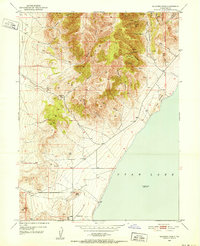
 1951 Pelican Point1951 Print · USGSThe northern reaches of Utah Lake are captured here in the early fifties, showing the area's transition between agricultural life and heavy industry. Researchers can trace the dual rail paths of the Union Pacific and the Denver and Rio Grande Western or locate the Calcite Quarry near Pelican Point.
 - 1951 Map of Jordan Narrows, 1952 Print
 1951 Jordan Narrows1952 Print · USGSThe Jordan River valley at the Salt Lake and Utah County border was a hub of irrigation and rail in the early fifties. Genealogists and local historians can trace the foundations of Bluffdale, the boundaries of Camp Williams, and the site of the Utah State Prison.6 unique versions available
 - 1951 Map of Saratoga Springs, 1952 Print
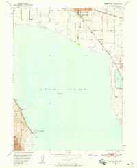
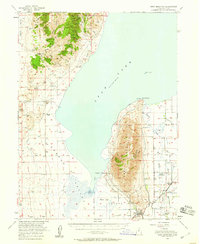
 1951 Saratoga Springs1952 Print · USGSThe northern shore of Utah Lake and the foothills of the Lake Mountains appear here in the early fifties. Researchers can trace the water works of the Murdock Pumping Sta and locate the historic Clay Pits or the settlement at Landrock.6 unique versions available
 - 1951 Map of Lehi, 1953 Print
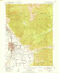
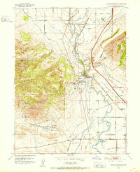
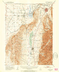
 1951 Lehi1953 Print · USGSThe northern Utah County valley in the early fifties reveals a landscape of expanding towns and intricate irrigation. Genealogists can trace family sites from Lehi to Alpine, including the American Fk Training Sch and the Pioneer Mem Cem.5 unique versions available
 - 1951 Map of Santaquin, 1953 Print
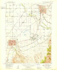
 1951 Santaquin1953 Print · USGSThe orchards and rail junctions of central Utah appear here in the early fifties, from the grid of Santaquin to the valley farms of Mona. Researchers can trace the legacy of the Privateer Mine and family landmarks like Lunt-Lattimer Spring and Burriston Ponds.3 unique versions available
 - 1952 Map of Lincoln Point
 1952 Lincoln Point1952 Print · USGSUtah Lake and the northern tip of West Mountain are captured here in the early fifties, showing the area's natural state before late-century growth. Researchers can trace the rugged shoreline around Lincoln Point and locate the isolated Bird Island.
 - 1952 Map of Santaquin Peak, 1954 Print
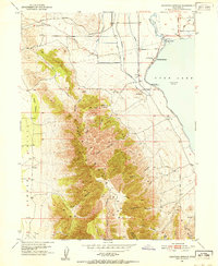
 1952 Santaquin Peak1954 Print · USGSThe high peaks and forest canyons of central Utah are mapped here in the early fifties, showing the mountain corridor before modern development. Researchers can find old rail routes along Thistle Creek, the Wimmer Ranch homestead, and the remote Payson Guard Station.3 unique versions available
 - 1952 Map of Draper, 1954 Print
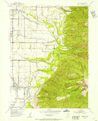 1952 Draper1954 Print · USGSThe Salt Lake Valley at the start of the fifties reveals a landscape of irrigation canals, early private airfields, and rail spurs. Genealogists and local historians can trace the foundations of Draper, Union, and Sandy, or locate the Union Cemetery and the Historic Mon Temple Granite Quarry.2 unique versions available
 - 1953 Map of Tooele, 1968 Print
 1953 Tooele1968 Print · USGSTooele County is shown here in the 1950s, a vast landscape transitioning between the industrial growth of the Salt Lake Valley and isolated military testing grounds. Researchers can trace the routes of the Western Pacific railroad and locate historic outposts like Iosepa Ranch and St John Station.3 unique versions available
 - 1953 Map of Delta, 1969 Print
 1953 Delta1969 Print · USGSWest-central Utah in the early fifties shows a landscape of vast desert playas and rising mountain ranges. Genealogists and historians can trace rail sidings like Champlin Siding, local industry at the Tungsten Mill, and historic outposts such as Fort Deseret.3 unique versions available
 - 1954 Map of Tintic Mountain, 1956 Print
 1954 Tintic Mountain1956 Print · USGSThe Tintic Mountains in the mid-1950s reveal a high-desert landscape defined by remote mining claims and isolated ranching. Researchers can trace historic operations like the Evelyn Mine or locate landmarks such as Hancock Ranch and the geological curiosity Paul Bunyans Woodpile.3 unique versions available
Showing maps 1-25 of 35
Top cities of Utah County
- Provo historical maps
- Orem historical maps
- Lehi historical maps
- Eagle Mountain historical maps
- Saratoga Springs historical maps
- Spanish Fork historical maps
See more
Frequently asked questions
- What are the different types of historical maps available for Utah County?
- What is the oldest map of Utah County?
- Where can I purchase historical maps of Utah County for my home or office?
- Where can I download high-res historical maps of Utah County?
- Are there historical topographic maps available for Utah County?
- Is there historical aerial imagery available for Utah County?
- Where are historical maps of Utah County sourced from?