1970s Maps of Utah County, Utah
Explore 14 historic maps of Utah County from the 1970s. These maps offer a rare glimpse into what life looked like during the 1970s — showing old roads, neighborhoods, homes, and landmarks that have changed or disappeared over time.
Whether you're researching your family's past, planning a metal detecting trip, or studying how Utah County's landscape evolved across the 1970s, these high-resolution maps are a powerful tool for exploring the history of this region.
- Focus on a specific era: All maps on this page are from the 1970s, giving you a focused view of this time period.
- See what’s changed: Compare century-old streets, trails, and buildings to today's modern landscape using overlays and satellite layers.
- Research with precision: Use these maps for genealogy, historical research, land use analysis, or educational projects.
- View, download, or print: Maps are fully viewable online in high resolution, and can be downloaded or printed for your own records.
Start exploring Utah County's history through authentic maps from the 1970s. This is your window into the past.
Utah County, UT maps
(14)- 1975 Map of Cedar Fort, 1986 Print
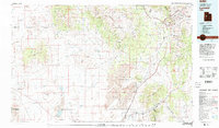
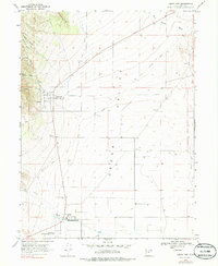 1975 Cedar Fort1986 Print · USGSThe western Cedar Valley in the mid-1970s remains a landscape shaped by early frontier history and military outposts. Researchers can trace the legacy of the Old West at the Stage Coach Inn and Camp Floyd, or follow the path of the Old Grade Railroad.
 - 1978 Map of Soldier Summit, 1979 Print
 1978 Soldier Summit1979 Print · USGSHigh in the Wasatch Range during the 1970s, this area centers on the vital mountain pass used by the Denver and Rio Grande Western railroad. Researchers can trace the Old Indian Treaty Boundary and locate infrastructure like the Soldier Summit Water Tank and remote Prospect mines.2 unique versions available
 - 1978 Map of Scofield Reservoir, 1979 Print
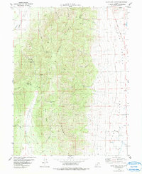
 1978 Scofield Reservoir1979 Print · USGSThe high Utah plateau during the late 1970s reveals a landscape of industrial transitions and mountain recreation. Follow the Old Railroad Grade past The Backswitch or locate legacy sites like Bennion and the Bear Prospect.
 - 1979 Map of Colton
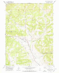
 1979 Colton1979 Print · USGSCarbon and Utah counties are captured in the late seventies, showing the industrial pulse of the high plateau. Genealogists and historians can trace the rail lines of the Denver and Rio Grande Western through Colton or locate specific Quarries and Prospects.2 unique versions available
 - 1979 Map of Goshen
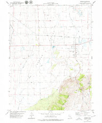 1979 Goshen1979 Print · USGSGoshen and Elberta are captured here in the late 1970s, showcasing the agricultural development and water systems of the southern Utah Valley. Researchers can trace irrigation networks like Warm Springs Ditch or locate local landmarks including the Rodeo Ground and the town Cem.
 - 1979 Map of Lynndyl
 1979 Lynndyl1979 Print · USGSThe Tintic mining district and the West Desert come alive in this late 1970s survey of central Utah. Genealogists and historians can trace the rail-and-mine economy through settlements like Eureka, Silver City, and the Union Pacific siding at Soma.2 unique versions available
 - 1979 Map of Payson Lakes
 1979 Payson Lakes1979 Print · USGSHigh mountain ridges south of Provo are captured here in the late seventies as a landscape of mining and recreation. Researchers can trace historic family holdings like Wimmer Ranch alongside the Golden Relief Mine and Payson Lake Guard Sta.
 - 1979 Map of Birdseye
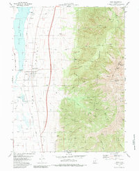
 1979 Birdseye1979 Print · USGSThe Thistle Creek canyon and the high ridges of Utah County are captured here in the late seventies, just before major geological changes. Family historians and researchers can trace the Denver and Rio Grande Western rail line past Birdseye and the Birdseye Quarry.
 - 1979 Map of Rush Valley
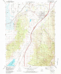
 1979 Rush Valley1979 Print · USGSTooele and Utah Counties during the late seventies reveal a unique transition from historic mining and ranching to modern military operations. Researchers can trace the Union Pacific Railroad past historic sites like Fairfield and mining camps such as Ophir.2 unique versions available
 - 1979 Map of Slate Jack Canyon
 1979 Slate Jack Canyon1979 Print · USGSThe high terrain of the Juab and Utah county line comes into focus in the late seventies, showing a landscape defined by seasonal springs and deep canyons. Researchers can trace historic ranching and transit marks like Goshen Canyon Road, Lunt-Lattimer Spring, and the unique The Devils Stairs.
 - 1979 Map of Mona, 1983 Print
 1979 Mona1983 Print · USGSJuab Valley and the slopes of Mount Nebo are captured in the late seventies as a landscape of mountain trails and valley agriculture. Researchers can trace early Pioneer roots at Pioneer Memorial Park (Cem) or locate historical mining sites like the Privateer Mine.
 - 1979 Map of Santaquin, 1984 Print
 1979 Santaquin1984 Print · USGSSantaquin and the fertile valleys of central Utah are captured in the late seventies as the region balanced its mining heritage with a growing rail-and-water economy. Genealogists and historians can trace the footprint of Genola, local mines in Santaquin Canyon, and the routes of the Union Pacific railroad.
 - 1979 Map of Spencer Canyon, 1985 Print
 1979 Spencer Canyon1985 Print · USGSThe high canyons of the Utah and Sanpete county border are documented here in the late seventies. You can trace the Denver and Rio Grande Western rail line and locate high-mountain water sources like Madsen Lake and Hartney Lake.
 - 1979 Map of Nebo Basin, 1985 Print
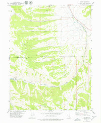
 1979 Nebo Basin1985 Print · USGSThe high basins and forest ridges of the Uinta range are captured here in the late seventies, showing the area's recreation and grazing infrastructure. Trace the historic route of the Nebo Loop Road past the Devils Kitchen and the Cottonwood Campground.
End of results
Showing maps 1-14 of 14
Top cities of Utah County
- Provo historical maps
- Orem historical maps
- Lehi historical maps
- Eagle Mountain historical maps
- Saratoga Springs historical maps
- Spanish Fork historical maps
See more
Frequently asked questions
- What are the different types of historical maps available for Utah County?
- What is the oldest map of Utah County?
- Where can I purchase historical maps of Utah County for my home or office?
- Where can I download high-res historical maps of Utah County?
- Are there historical topographic maps available for Utah County?
- Is there historical aerial imagery available for Utah County?
- Where are historical maps of Utah County sourced from?