1960s Maps of Utah County, Utah
Explore 24 historic maps of Utah County from the 1960s. These maps offer a rare glimpse into what life looked like during the 1960s — showing old roads, neighborhoods, homes, and landmarks that have changed or disappeared over time.
Whether you're researching your family's past, planning a metal detecting trip, or studying how Utah County's landscape evolved across the 1960s, these high-resolution maps are a powerful tool for exploring the history of this region.
- Focus on a specific era: All maps on this page are from the 1960s, giving you a focused view of this time period.
- See what’s changed: Compare century-old streets, trails, and buildings to today's modern landscape using overlays and satellite layers.
- Research with precision: Use these maps for genealogy, historical research, land use analysis, or educational projects.
- View, download, or print: Maps are fully viewable online in high resolution, and can be downloaded or printed for your own records.
Start exploring Utah County's history through authentic maps from the 1960s. This is your window into the past.
Utah County, UT maps
(24)- 1960 Map of Salt Lake City
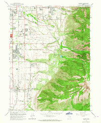
 1960 Salt Lake City1960 Print · USGSThe Wasatch Front and High Uintas are captured mid-century as the Salt Lake Valley underwent significant postwar expansion. Genealogists and historians can trace rail lines like the Union Pacific and locate established landmarks such as Fort Douglas, Camp Williams, and the Bingham Canyon Mine.
 - 1960 Map of Price
 1960 Price1960 Print · USGSCentral Utah in the late fifties was a landscape of coal-hauling railroads and high plateau settlements. Genealogists and local historians can trace the rail-to-river economy from Price to the mountain mining camps of Hiawatha, Dragerton, and Sunnyside.2 unique versions available
 - 1962 Map of Price
 1962 Price1962 Print · USGSCentral Utah during the early sixties shows a landscape balancing high-mountain forestry with valley agriculture and coal mining. Genealogists and historians can trace the Denver and Rio Grande Western rail lines through industrial hubs like Price or locate formerly active sites like Coal City (abandoned).
 - 1962 Map of Delta
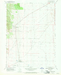
 1962 Delta1962 Print · USGSWest Central Utah in the early sixties reveals a landscape of desert agriculture and military testing grounds. Researchers can trace the Union Pacific line through Delta or locate historic sites like the Pony Express Monument and Silver City.
 - 1963 Map of Draper, 1964 Print
 1963 Draper1964 Print · USGSThe Salt Lake Valley undergoes rapid change in the early sixties as residential growth reaches toward the Wasatch range. Genealogists and historians can trace family locations near Draper and Butlerville, or locate the Temple Granite Quarry and early airfields like Alta Airpark.3 unique versions available
 - 1966 Map of Strawberry Reservoir NW, 1968 Print
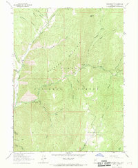
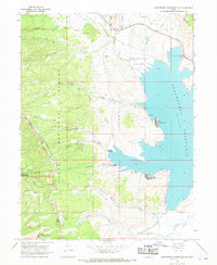 1966 Strawberry Reservoir NW1968 Print · USGSHigh in the Wasatch Range during the mid-sixties, this map documents the critical water infrastructure and early recreational camps of the Strawberry Valley. Researchers can trace the path of the Strawberry Tunnel and locate historical sites like Clarks Camp and the Bryants Fork Guard Station.2 unique versions available
 - 1966 Map of Strawberry Reservoir SW, 1969 Print
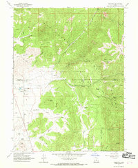
 1966 Strawberry Reservoir SW1969 Print · USGSThe high ridges of the Wasatch and Utah County border are captured in the mid-1960s, showing a landscape shaped by water and forest management. Researchers can trace remote routes like the Treaty Bdy Trail and locate the historic Willow Creek Guard Station.3 unique versions available
 - 1967 Map of Two Tom Hill, 1969 Print
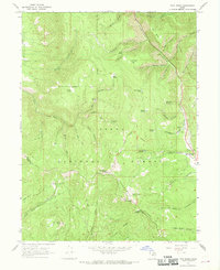
 1967 Two Tom Hill1969 Print · USGSThe high backcountry of the Wasatch Range is captured here in the late sixties, highlighting the intersection of forest management and early recreation. Researchers can locate the Diamond Fork Guard Station, trace the INDIAN TREATY BOUNDARY, and find remote sites like Springville Crossings.2 unique versions available
 - 1967 Map of Granger Mtn, 1969 Print
 1967 Granger Mtn1969 Print · USGSThe canyons and ridgelines of the Wasatch Range come into focus in the late 1960s, showing a landscape managed for recreation and watershed. You can trace early forest infrastructure like the Hobble Cr Guard Sta and several camps including Kolob Campground and Sulphur Campground.2 unique versions available
 - 1967 Map of Indianola, 1969 Print
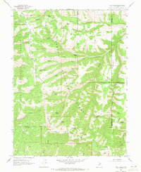
 1967 Indianola1969 Print · USGSThe Sanpete Valley and the high ridges of the Manti National Forest come into focus during the late 1960s. Genealogists and local historians can locate the Spencer Cem near Indianola and trace old industrial sites like the Crayons Mine and Gravel Pit.3 unique versions available
 - 1967 Map of Mill Fork, 1969 Print
 1967 Mill Fork1969 Print · USGSUpper Spanish Fork Canyon was a critical mountain corridor for the Denver and Rio Grande Western railroad in the 1960s. Trace the old tracks and water sources through the mountains past the Mill Fork settlement, Terry Flat, and the Narrows.
 - 1967 Map of Twin Peaks, 1969 Print
 1967 Twin Peaks1969 Print · USGSThe high ridges of the Wasatch Range come into focus in the late sixties, showing a landscape defined by forest boundaries and remote trails. Trace early land divisions and mountain landmarks like the Old Indian Treaty Boundary, Strawberry Peak, and Barrys Reservoir.2 unique versions available
 - 1967 Map of Thistle, 1969 Print
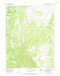
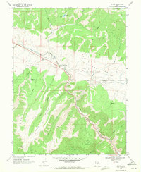
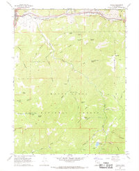 1967 Thistle1969 Print · USGSThe rail junction at Thistle and the winding canyons of the late sixties come alive in this survey. Map collectors can trace the Denver & Rio Grande Western line past the Thistle Substation and search for family landmarks like Smiths Reservoir.2 unique versions available
 - 1967 Map of Wallsburg Ridge, 1969 Print
 1967 Wallsburg Ridge1969 Print · USGSWasatch and Utah County mountain lands are documented here in the late sixties, showing the rugged backcountry of the Uinta National Forest. Researchers can trace old mountain routes like the Sheep Canyon Trail and find family-named landmarks like Fullmer Hollow and Johns Hollow.
 - 1967 Map of Billies Mtn., 1969 Print
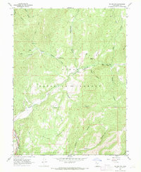 1967 Billies Mtn.1969 Print · USGSUtah County during the late sixties showcases a high-altitude wilderness managed by the Uinta National Forest and intersected by vital rail lines. You can trace the path of the D & R G W RR or locate remote sites like Patrick Place and the Diamond Battle Historical Monument.3 unique versions available
 - 1967 Map of Rays Valley, 1969 Print
 1967 Rays Valley1969 Print · USGSThe Uinta National Forest in the late 1960s is a landscape of numbered mountain creeks and deep canyons centered on Rays Valley. Researchers can locate remote outposts like the First Water Cabin or trace old routes including the Pack Trail near Teat Mountain.2 unique versions available
 - 1967 Map of C Canyon, 1970 Print
 1967 C Canyon1970 Print · USGSThe high ridges of the Manti-La Sal National Forest are captured here in the late sixties, showing the rugged intersection of Utah and Sanpete Counties. Researchers can trace historic paths like the Wagon Road and locate landmarks such as Browns Peak and Rock Spring.
 - 1968 Map of Mercur, 1970 Print
 1968 Mercur1970 Print · USGSThe Oquirrh Mountains mining district comes into sharp focus during the late 1960s, revealing a landscape of industrial extraction and high-altitude settlements. Trace the legacy of gold and silver production at the Geyser Marion Mine or locate the historical footprints of Sunshine (Site) and Manning (Site).2 unique versions available
 - 1968 Map of Cedar Fort, 1970 Print
 1968 Cedar Fort1970 Print · USGSCedar Valley and the Oquirrh foothills appear here in the late sixties, capturing a landscape deeply rooted in pioneer and military history. Trace the legacy of the Old West at the Stage Coach Inn and find the Old Railroad Grade running through Fairfield.
 - 1968 Map of Lowe Peak, 1971 Print
 1968 Lowe Peak1971 Print · USGSThe Oquirrh Mountains at the end of the sixties reveal a landscape defined by military boundaries and mining history. Trace the high-altitude Old Military Road or locate historical extraction sites like the Old Mayflower Mine and Queen Mine.
 - 1969 Map of Flat Ridge, 1971 Print
 1969 Flat Ridge1971 Print · USGSThe high ridges and deep hollows of the Wasatch-Duchesne border are shown in the late sixties as a network of forest boundaries and jeep trails. Researchers can locate remote high-country landmarks like the Indian Guard Station, the Old Indian Treaty Bdy, and Bown Corral Reservoir.
 - 1969 Map of Kyune, 1971 Print
 1969 Kyune1971 Print · USGSThe industrial corridor of Carbon County is captured here in the late sixties, where the railroad and river define the landscape. Local historians can trace the Denver and Rio Grande Western line past the settlement of Kyune and locate old Mines and Gravel Pits tucked into the canyons.2 unique versions available
 - 1969 Map of Gray Head Peak, 1971 Print
 1969 Gray Head Peak1971 Print · USGSThe high ridges of Duchesne County are captured here in the late sixties, highlighting the intersection of the Ashley National Forest and tribal lands. Researchers can trace the Old Indian Treaty Boundary across Fossil Ridge and locate numerous named water sources like Olsen Spring and Mud Spring.
 - 1969 Map of Matts Summit, 1971 Print
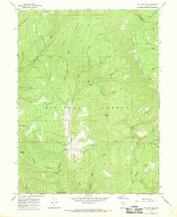
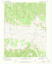 1969 Matts Summit1971 Print · USGSHigh-altitude ranching and forest lands in the late sixties define this portion of the Utah interior. Researchers can locate remote landmarks like the Downard Cabin and Matts Summit or trace the early water systems of Little Boulder Dam.
End of results
Showing maps 1-24 of 24
Top cities of Utah County
- Provo historical maps
- Orem historical maps
- Lehi historical maps
- Eagle Mountain historical maps
- Saratoga Springs historical maps
- Spanish Fork historical maps
See more
Frequently asked questions
- What are the different types of historical maps available for Utah County?
- What is the oldest map of Utah County?
- Where can I purchase historical maps of Utah County for my home or office?
- Where can I download high-res historical maps of Utah County?
- Are there historical topographic maps available for Utah County?
- Is there historical aerial imagery available for Utah County?
- Where are historical maps of Utah County sourced from?