1920s Maps of Virginia
Explore 206 historic maps of Virginia from the 1920s. These maps offer a rare glimpse into what life looked like during the 1920s — showing old roads, neighborhoods, homes, and landmarks that have changed or disappeared over time.
Whether you're researching your family's past, planning a metal detecting trip, or studying how Virginia's landscape evolved across the 1920s, these high-resolution maps are a powerful tool for exploring the history of this region.
- Focus on a specific era: All maps on this page are from the 1920s, giving you a focused view of this time period.
- See what’s changed: Compare century-old streets, trails, and buildings to today's modern landscape using overlays and satellite layers.
- Research with precision: Use these maps for genealogy, historical research, land use analysis, or educational projects.
- View, download, or print: Maps are fully viewable online in high resolution, and can be downloaded or printed for your own records.
Start exploring Virginia's history through authentic maps from the 1920s. This is your window into the past.
Virginia maps
- 1920 Map of Holland
 1920 Holland1920 Print · USGSCoastal plain life at the end of the Great War centers on the river-and-rail hubs of Franklin and Holland. Genealogists can trace family footprints across dozens of country schools like Holmes School and river crossings such as Joyners Bridge and Manning Ferry.2 unique versions available
 - 1920 Map of Ivor
 1920 Ivor1920 Print · USGSCoastal plain life in Southampton and Isle of Wight counties is captured here just after the Great War, when rail and river travel still shaped the landscape. Genealogists can locate family landmarks like Tucker Swamp Church, Crumplers School, and Millfield Millpond.2 unique versions available
 - 1920 Map of Wicomico
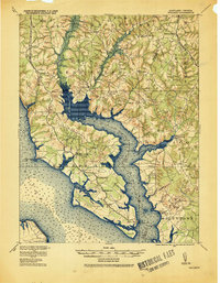 1920 Wicomico1920 Print · USGSThe Potomac and Wicomico riverfronts appear here as they were just after the Great War, when steamboat wharves and ferries still anchored local commerce. Trace the old rail lines to Bel Alton Cox Sta or locate long-standing landmarks like Charlotte Hall and Ludlow Ferry.
 - 1920 Map of Homeville
 1920 Homeville1920 Print · USGSCoastal plain life in Sussex and Southampton counties thrived along the rails and rivers in the early twentieth century. Researchers can trace the legacy of small communities and crossroads schools like Sebrell, Hickory Hill School, and the Union Hill Church near the Nottoway River.3 unique versions available
 - 1920 Map of Wise
 1920 Wise1920 Print · USGSThe coal and rail country of Southwest Virginia is captured here in the years following the Great War. Genealogists can locate family landmarks such as Fort Blackmore, Grays School, and the scattered settlements of Dunbar and Esserville.
 - 1920 Map of Lawrenceville
 1920 Lawrenceville1920 Print · USGSBrunswick County at the height of the steam-rail era shows a landscape crisscrossed by three major rail lines and dozens of small rural communities. Genealogists can trace family connections to many churches and schools, such as Little Mount Church (Colored), Masons Mill School, and the County Poor Farm.
 - 1920 Map of King William
 1920 King William1920 Print · USGSCoastal Virginia during the late teens and early twenties reveals a landscape of river-bend settlements and tidal swamps. Researchers can trace the Pamunkey Indian Reservation, early river crossings like Piping Tree Ferry, and rail depots at Tunstall.4 unique versions available
 - 1920 Map of White Plains
 1920 White Plains1920 Print · USGSThe Virginia and North Carolina borderlands come to life in this 1920 survey of the Meherrin and Roanoke river basins. Genealogists can trace family names at Drumgoole Store and Phipps Store, or locate old schoolhouse sites like Meherrin School and Webb School.4 unique versions available
 - 1920 Map of Coeburn
 1920 Coeburn1920 Print · USGSSouthwest Virginia during the height of its rail and timber era reveals a complex network of company towns and mountain settlements. Genealogists can trace family footprints near Dante, St Paul, and Castlewood, or locate rural institutions like the Greenwood School and Carter School.5 unique versions available
 - 1920 Map of Petersburg
 1920 Petersburg1920 Print · USGSThe West Virginia and Virginia borderlands were a network of tight-knit mountain communities just after the Great War. Genealogists can locate family-named sites like Schmuckers School and Sites Chapel or trace the early Smoke Hole Settlement.3 unique versions available
 - 1920 Map of Boykins
 1920 Boykins1920 Print · USGSCoastal plain settlements near the Virginia and North Carolina line thrive along the river systems and railroads of the post-WWI era. Genealogists can trace family roots at Ebenezer Church, Johnsons School, and mills like Smiths Mill.2 unique versions available
 - 1920 Map of Arringdale
 1920 Arringdale1920 Print · USGSCoastal plain life at the state line centered on the river and rail just after the Great War. Genealogists can locate family-named landmarks like Pearsons Millpond and several rural centers including Rising Star School, Hebron Church, and Arringdale.3 unique versions available
 - 1920 Map of Crisfield
 1920 Crisfield1920 Print · USGSMaryland's seafood capital and the isolated island communities of the Chesapeake are captured just after the First World War. Researchers can trace the waterfront rail lines of the N.Y.P. & N. R.R. or locate ancestral homes in Sackertown, Birdtown, and Ewell.
 - 1921 Map of Callaghan
 1921 Callaghan1921 Print · USGSThe West Virginia and Virginia borderlands come alive in this early 1920s survey of the mountain gaps and valley drafts. Researchers can trace rural life through numerous country schools like Bound School and landmarks such as Columbia Sulphur Springs and Wileys Crossing.
 - 1921 Map of Mc Kenney
 1921 Mc Kenney1921 Print · USGSSouthern Virginia at the turn of the decade reveals a landscape of tobacco-country schools, churches, and river crossings. Trace the old rail lines of the Virginian and find local landmarks like Smoky Ordinary, Barnes and Parsons Store, and Laxottes Ford.2 unique versions available
 - 1921 Map of Newport News
 1921 Newport News1921 Print · USGSThe Virginia tidewater area comes alive in the early twentieth century, showing a landscape defined by maritime industry and massive military installations. Genealogists and historians can trace rail lines and early settlements from Camp Stuart down to Jolliff School and the Dismal Swamp.4 unique versions available
 - 1921 Map of Orkney Springs
 1921 Orkney Springs1921 Print · USGSHardy County life in the early 1920s was centered in the valley between the high ridges of Shenandoah and South Fork mountains. Genealogists can trace family footprints through a dense network of rural schools and churches, including Jenkins Chapel, Mathias, and the Lumber RR.2 unique versions available
 - 1921 Map of Big Stone Gap
 1921 Big Stone Gap1921 Print · USGSIn the early 1920s, the coal and rail networks of Wise and Lee Counties were at their peak. Genealogists and historians can trace old settlements and rural hubs like Keokee, Johnsons Mill PO, and Stonega along the Southern RR and the Powell River.
 - 1921 Map of Petersburg
 1921 Petersburg1921 Print · USGSEastern West Virginia at the start of the twenties shows a landscape of mountain hollows tied together by the Baltimore and Ohio at Petersburg. Genealogists can trace family names through landmarks like Hedrick Church, Crites School, and Ketterman.
 - 1921 Map of White Sulphur Springs
 1921 White Sulphur Springs1921 Print · USGSThe Greenbrier Valley in the early twenties reveals a landscape of dense rural settlements and early mountain thoroughfares. Genealogists can trace family footprints across dozens of local sites like Germany School, Balm of Gilead Church, and White Sulphur Springs.2 unique versions available
 - 1921 Map of Wise
 1921 Wise1921 Print · USGSWise County in the early twentieth century was a landscape of coal-town industry and mountain schools. Search for family roots in settlements like Norton, Big Stone Gap, and Glamorgan, or locate rural landmarks such as Cox Chapel and Buffalo School.2 unique versions available
 - 1921 Map of Chatham
 1921 Chatham1921 Print · USGSPittsylvania County's rural heartland is captured here in the early twenties, anchored by the railway and the ridge of White Oak Mountain. Genealogists and historians can locate dozens of country landmarks like Tight Squeeze, Whittles Depot, and Mountain Spring Church.
 - 1921 Map of Ronceverte
 1921 Ronceverte1921 Print · USGSThe West Virginia and Virginia borderlands come alive in this early 1920s record of the Greenbrier Valley and Allegheny ridges. Genealogists can trace family roots through numerous local landmarks like Organ Cave, Red Mill, and the Highland Green School.2 unique versions available
 - 1921 Map of Lawrenceville
 1921 Lawrenceville1921 Print · USGSBrunswick County in the years following the Great War shows a landscape defined by its bustling rail junctions and riverside mills. Genealogists and local historians can trace family-named sites like Meredithville P.O., Barrows Store, and the County Poor Farm.2 unique versions available
 - 1922 Map of Fort Seybert
 1922 Fort Seybert1922 Print · USGSPendleton County's South Fork Valley is captured in the early 1920s, showing a landscape of remote mountain homesteads and small valley hamlets. Genealogists can locate family landmarks like Locust Grove School, New Bethel Church, and the high peaks of Shenandoah Mountain.2 unique versions available
Showing maps 1-25
Top cities of Virginia
- Virginia Beach historical maps
- Chesapeake historical maps
- Arlington historical maps
- Norfolk historical maps
- Richmond historical maps
- Newport News historical maps
See more
Top counties of Virginia
- Fairfax County historical maps
- Virginia Beach historical maps
- Prince William County historical maps
- Loudoun County historical maps
- Chesterfield County historical maps
- Henrico County historical maps
See more
Frequently asked questions
- What are the different types of historical maps available for Virginia?
- What is the oldest map of Virginia?
- Where can I purchase historical maps of Virginia for my home or office?
- Where can I download high-res historical maps of Virginia?
- Are there historical topographic maps available for Virginia?
- Is there historical aerial imagery available for Virginia?
- Where are historical maps of Virginia sourced from?