Old Maps of Wisconsin for Academic Research
Study the evolution of Wisconsin with 3,569 high-resolution historic maps. Whether you're teaching, researching, or modeling changes in land use, these maps provide essential visual documentation of urban, environmental, and geographic change.
- Analyze long-term change: Track patterns in development, transportation, and natural features.
- Ideal for environmental or urban studies: Support academic projects with primary historical map data.
- Use in the classroom or lab: Educators and researchers rely on these maps to bring historical context to life.
These maps are a powerful tool for teaching, research, and visualizing how Wisconsin has changed over the decades.
Wisconsin maps
(3,569)- 1889 Map of Evansville
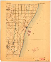
 1889 Evansville1889 Print · USGSSouthern Wisconsin at the end of the nineteenth century was a landscape of growing rail towns and post offices scattered across glacial drumlins. Genealogists can trace family roots through the early plats of Evansville, Oregon, and the Lake View Post Office.
 - 1890 Map of Madison
 1890 Madison1890 Print · USGSMadison and its surrounding lake country are captured in the late 1880s as the capital city began to dominate the central isthmus. Researchers can trace early rail corridors like the Madison and Northern Railroad and locate settlements such as Mendota and Token Creek.
 - 1890 Map of Sun Prairie
 1890 Sun Prairie1890 Print · USGSEastern Dane County was a landscape of budding rail towns and glacial ridges in the late nineteenth century. Genealogists and local historians can trace the early footprints of Sun Prairie, Deerfield, and Marshall along the active corridors of the Chicago and Northwestern Railroad.2 unique versions available
 - 1890 Map of Stoughton
 1890 Stoughton1890 Print · USGSSouthern Wisconsin during the 1890s shows a landscape of thriving river towns and expanding rail networks. Researchers can trace early family homesteads near Stebbinsville, Cooksville, and Fulton Center while following the historic route of the Chicago Milwaukee and St Paul Railroad.6 unique versions available
 - 1891 Map of Waterloo
 1891 Waterloo1891 Print · USGSJefferson County was an agricultural and rail landscape during the 1890s, defined by its winding river systems and glacial lakes. Genealogists can trace property locations near Lake Mills, Aztalan, and the Crawfish River during this period of early growth.
 - 1891 Map of Koshkonong
 1891 Koshkonong1891 Print · USGSJefferson County was an evolving hub of river power and rail transit in the 1890s. Researchers can trace the early footprints of Jefferson and Fort Atkinson or locate rural landmarks like Busseyville and Cold Spring.
 - 1891 Map of Bayview
 1891 Bayview1891 Print · USGSSouthern Wisconsin at the close of the nineteenth century reveals a landscape of burgeoning rail corridors and quiet farming townships along the Lake Michigan shore. Genealogists and local historians can trace early settlements like Paynesville, Caledonia, and Franksville.2 unique versions available
 - 1891 Map of Muskego, 1896 Print
 1891 Muskego1896 Print · USGSSoutheast Wisconsin in the early 1890s was a landscape of expansive lake systems and rural townships connected by early rail and river routes. Genealogists can trace family holdings and vanished crossroads like Big Bend, Prospect Hill, and Denoon.
 - 1891 Map of Janesville, 1956 Print
 1891 Janesville1956 Print · USGSThe Rock River corridor in the 1890s appears as a burgeoning industrial landscape anchored by the rail hubs of Janesville and Beloit. Genealogists and historians can trace old property sites near Hanover, Afton, and the early settlements of Stevens and Fellows.
 - 1892 Map of Milwaukee
 1892 Milwaukee1892 Print · USGSWisconsin’s industrial heartland is documented here during a period of rapid rail expansion and urban growth along the western shore of Lake Michigan. Genealogists and historians can trace the early rail junctions and settlements such as Schwartzburg Junction, Mequon Sta., and Thiensville.2 unique versions available
 - 1892 Map of Waukesha
 1892 Waukesha1892 Print · USGSSoutheast Wisconsin in the 1890s was a critical junction of rail lines and river valleys connecting small industrial settlements. Trace the early development of Waukesha and Wauwatosa before suburban expansion, or locate vanished stops like Templeton and Brookfield Junction.
 - 1892 Map of Racine
 1892 Racine1892 Print · USGSSoutheastern Wisconsin's lakeshore was a hub of rail and river industry at the close of the nineteenth century. Genealogists and historians can trace the early street grids of Racine and Kenosha or locate vanished rail stops at Western Union Junction and Windsor.2 unique versions available
 - 1892 Map of Watertown
 1892 Watertown1892 Print · USGSJefferson and Dodge counties at the close of the nineteenth century are defined by their winding river valleys and newly established rail corridors. Genealogists can trace family roots in early settlements like Watertown, Ixonia, and Sullivan, or follow the Rock River to its junction with the Oconomowoc River.
 - 1892 Map of Madison
 1892 Madison1892 Print · USGSDane County in the late nineteenth century centers on the emerging isthmus city of Madison and its surrounding glacial lakes. Genealogists and historians can trace rail-aligned settlements like Waunakee, De Forest, and Mac Farland alongside the banks of Lake Mendota.3 unique versions available
 - 1892 Map of Oconomowoc
 1892 Oconomowoc1892 Print · USGSWaukesha County's lake country is captured in the early 1890s, revealing a landscape defined by glacial waters and nascent rail lines. Researchers can trace the early development of Delafield and Hartland or locate old stops like Lakeside Station and Giffords.4 unique versions available
 - 1892 Map of Whitewater
 1892 Whitewater1892 Print · USGSSoutheastern Wisconsin's glaciated landscape is revealed in the late nineteenth century as the rail network began to shape local growth. Trace the path of the Chicago Milwaukee And St. Paul Railroad through Whitewater, Palmyra, and the marshes of the Bark River.
 - 1892 Map of Port Washington
 1892 Port Washington1892 Print · USGSOzaukee County’s lakefront and river valleys are captured here during the 1890s as the railroad era transformed the Wisconsin coast. Researchers can trace historic property locations and vanished stops like Ulao Station, Deekers, and Hamilton along the banks of the Milwaukee River.
 - 1892 Map of Eagle
 1892 Eagle1892 Print · USGSSoutheast Wisconsin's glaciated landscape is captured here in the late nineteenth century as new rail lines transformed the frontier into a network of dairy and mill towns. Genealogists can trace early homesteads and rail stops like Genesee Depot, Caldwell Prairie, and Eagleville near the shores of Phantom Lake.
 - 1893 Map of Delavan
 1893 Delavan1893 Print · USGSWalworth County at the close of the nineteenth century reveals a landscape of growing lakefront communities and vital rail junctions. Genealogists and historians can trace the early footprints of Delavan, Elkhorn, and Sharon, alongside lakeside landmarks like Williams Bay and Fontana.6 unique versions available
 - 1893 Map of Whitewater
 1893 Whitewater1893 Print · USGSThe dairy lands and glacial lake districts of southeastern Wisconsin are captured here in the late nineteenth century. Trace the early village footprints of Whitewater and Palmyra, or follow the iron path of the Prairie Du Chien Division Railroad past Lauderdale Lakes.7 unique versions available
 - 1893 Map of Janesville
 1893 Janesville1893 Print · USGSRock County at the close of the nineteenth century is a bustling hub of rail activity and river commerce. Genealogists and local historians can trace the early city footprints of Janesville and Beloit or locate vanished rural stops like Fellows and Stevens.4 unique versions available
 - 1893 Map of Silver Lake
 1893 Silver Lake1893 Print · USGSSoutheastern Wisconsin at the end of the nineteenth century is a land of emerging rail hubs and numerous glacial lakes. You can trace the path of the Chicago Milwaukee and St. Paul Railroad through Union Grove or explore the water-rich landscape around Silver Lake and Camp Lake.2 unique versions available
 - 1893 Map of Brodhead
 1893 Brodhead1893 Print · USGSSouthern Wisconsin is captured in the late nineteenth century as rail lines and river valleys shaped the landscape. Genealogists and historians can trace early village sites like Brodhead, Magnolia Station, and Orford along the Chicago Milwaukee and Saint Paul Railroad.5 unique versions available
 - 1893 Map of Shopiere
 1893 Shopiere1893 Print · USGSRock County's rural landscape is captured here in the 1890s, when steam rail dominated the local economy and travel. Genealogists and researchers can trace the early footprints of Clinton Junction, the winding path of Turtle Creek, and small rural centers like Emerald Grove.5 unique versions available
 - 1893 Map of Geneva
 1893 Geneva1893 Print · USGSSoutheastern Wisconsin thrived as a rail and lakeside hub in the 1890s. Genealogists and historians can trace old homesteads near Geneva, Slades Corners, and Springfield, or follow the routes of the Wisconsin Central Railroad.2 unique versions available
Showing maps 1-25 of 3,569
Top cities of Wisconsin
- Milwaukee historical maps
- Madison historical maps
- Green Bay historical maps
- Kenosha historical maps
- Racine historical maps
- Appleton historical maps
See more
Top counties of Wisconsin
- Milwaukee County historical maps
- Dane County historical maps
- Waukesha County historical maps
- Brown County historical maps
- Racine County historical maps
- Outagamie County historical maps
See more
Frequently asked questions
- What are the different types of historical maps available for Wisconsin?
- What is the oldest map of Wisconsin?
- Where can I purchase historical maps of Wisconsin for my home or office?
- Where can I download high-res historical maps of Wisconsin?
- Are there historical topographic maps available for Wisconsin?
- Is there historical aerial imagery available for Wisconsin?
- Where are historical maps of Wisconsin sourced from?