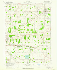
1960 Map of Arcadia
USGS Topo · Published 1962About this map
The Blanchard River meanders across this Hancock County landscape, providing a natural southern boundary for Marion township. To the east, the village of Arcadia sits at a junction of the New York Chicago and St Louis railroad and the Washington township line. This 1960 era survey reveals an agricultural region dotted with numerous family-named landmarks and rural institutions, including Salem Ch and the Memory Gardens Cem.
Find a feature on this map
35 named features on this map. Tap any name to fly to it.
Don’t see what you’re looking for? This feature index may not catch every label — zoom into the map to look around manually.
Map Details
Editions of this 1960 Arcadia Map
Other maps of this area

1901 · Fostoria
USGS Topo · 1:62,500

1903 · Fostoria
USGS Topo · 1:62,500

1903 · Findlay
USGS Topo · 1:62,500

1905 · Arlington
USGS Topo · 1:62,500

1907 · Arlington
USGS Topo · 1:24,000

1907 · Upper Sandusky
USGS Topo · 1:62,500

1950 · Marion
USGS Topo · 1:250,000

1956 · Toledo
USGS Topo · 1:250,000

1960 · Bloomdale
USGS Topo · 1:24,000

1960 · Alvada
USGS Topo · 1:24,000