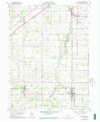
1960 Map of Arlington
USGS Topo · Published 1973About this map
The agricultural landscape of Hancock County transitions toward established villages in this mid-century survey. Arlington and Jenera serve as the primary hubs, with the latter situated along the Akron Canton and Youngstown rail corridor. The map reveals a dense network of rural community landmarks, including numerous family-named cemeteries such as Powell Cem, Hartman Cem, and Keller Cem.
Find a feature on this map
34 named features on this map. Tap any name to fly to it.
Don’t see what you’re looking for? This feature index may not catch every label — zoom into the map to look around manually.
Map Details
Editions of this 1960 Arlington Map
4 editions found
Other maps of this area

1903 · Findlay
USGS Topo · 1:62,500

1905 · Arlington
USGS Topo · 1:62,500

1907 · Bluffton
USGS Topo · 1:62,500

1907 · Arlington
USGS Topo · 1:24,000

1950 · Marion
USGS Topo · 1:250,000

1956 · Toledo
USGS Topo · 1:250,000

1960 · Rawson
USGS Topo · 1:24,000

1960 · Arlington
USGS Topo · 1:24,000
1960 · Findlay
USGS Topo · 1:24,000

1960 · Mt Blanchard
USGS Topo · 1:24,000