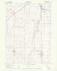
1960 Map of Arlington
USGS Topo · Published 1973About this map
Arlington and Jenera anchor this Hancock County landscape, where the agricultural grid of Northwest Ohio is punctuated by an active oil-and-gas industry. The 1960s terrain is heavily influenced by the drainage patterns of Eagle Creek and Tiderishi Creek, which wind through the townships of Eagle and Jackson. Numerous family and community landmarks are documented, including the Hartman Cem, Bishop Cem, and Keller Cem, along with social centers like the Grange Hall.
Find a feature on this map
29 named features on this map. Tap any name to fly to it.
Don’t see what you’re looking for? This feature index may not catch every label — zoom into the map to look around manually.
Map Details
Editions of this 1960 Arlington Map
4 editions found
Other maps of this area

1903 · Findlay
USGS Topo · 1:62,500

1905 · Arlington
USGS Topo · 1:62,500

1907 · Bluffton
USGS Topo · 1:62,500

1907 · Arlington
USGS Topo · 1:24,000

1950 · Marion
USGS Topo · 1:250,000

1956 · Toledo
USGS Topo · 1:250,000

1960 · Rawson
USGS Topo · 1:24,000

1960 · Arlington
USGS Topo · 1:24,000
1960 · Findlay
USGS Topo · 1:24,000

1960 · Mt Blanchard
USGS Topo · 1:24,000