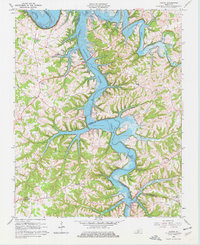
1965 Map of Austin
USGS Topo · Published 1977About this map
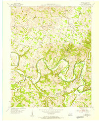
Barren River Lake dominates the central landscape of this mid-1960s survey, its winding branches reaching into the deep hollows of Barren and Allen counties. The map reflects a rural economy in transition, where numerous Oil Wells are scattered across the western uplands near Cedar Springs. The distribution of local landmarks like Cedar Cross Ch, Hopewell Ch, and Corinth Ch indicates a dispersed population typical of the region before the consolidation seen in the Austin-Tracy Sch at Austin. The intricate shoreline of the reservoir is marked by recreational access points, including the Austin Boat Ramp and Browns Ford Boat Ramp, illustrating the transformation of the Barren River valley into a managed waterway. Traditional landforms like Manley Ridge and the prominent Capitol Hill remain key navigational points above the inundated creek mouths of Walnut Creek and Peter Creek.
Find a feature on this map
38 named features on this map. Tap any name to fly to it.
Don’t see what you’re looking for? This feature index may not catch every label — zoom into the map to look around manually.
Map Details
Editions of this 1965 Austin Map
4 editions found
Other maps of this area

1926 · Scottsville
USGS Topo · 1:62,500

1931 · Lafayette
USGS Topo · 1:62,500

1931 · Red Boiling Springs
USGS Topo · 1:62,500

1953 · Tracy
USGS Topo · 1:24,000

1953 · Glasgow South
USGS Topo · 1:24,000

1954 · Austin
USGS Topo · 1:24,000

1954 · Fountain Run
USGS Topo · 1:24,000

1954 · Petroleum
USGS Topo · 1:24,000

1954 · Scottsville
USGS Topo · 1:24,000
1954 · Meador
USGS Topo · 1:24,000