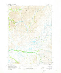
1954 Map of Bethel B-3
USGS Topo · Published 1973About this map
The Kilbuck Mountains dominate this portion of the Alaskan interior, carved by a complex network of waterways during the mid-1950s. The Kisaralik River serves as the primary drainage, featuring both Lower Falls and Upper Falls as prominent navigational and topographic markers. This 1954 field-annotated survey reveals a landscape defined by its hydrography, where Quicksilver Creek and Crooked Creek join a series of smaller tributaries like Salomon Creek and Akoswift Creek. The drainage patterns suggest a terrain of varied elevation, transitioning from the higher peaks of the Kilbuck range down to the marshy lowlands shown in the southeastern quadrant. The lack of roads or established settlements at the time of mapping emphasizes the remote character of this region, where Swift Creek and the Little Swift watercourses were the primary geographic identifiers.
Find a feature on this map
11 named features on this map. Tap any name to fly to it.
Don’t see what you’re looking for? This feature index may not catch every label — zoom into the map to look around manually.
Map Details
Editions of this 1954 Bethel B-3 Map
3 editions found
Other maps of this area

1950 · Bethel
USGS Topo · 1:250,000

1954 · Bethel C-4
USGS Topo · 1:63,360

1954 · Bethel C-3
USGS Topo · 1:63,360

1954 · Bethel A-4
USGS Topo · 1:63,360

1954 · Bethel B-3
USGS Topo · 1:63,360

1954 · Bethel B-4
USGS Topo · 1:63,360

1979 · Bethel A-3
USGS Topo · 1:63,360

1979 · Bethel A-2
USGS Topo · 1:63,360

1979 · Bethel C-2
USGS Topo · 1:63,360

1979 · Bethel B-2
USGS Topo · 1:63,360