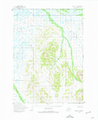
1954 Map of Bethel C-5
USGS Topo · Published 1977About this map
The Kasigluk River and its tributary, the Little Kasigluk River, dominate this mid-century landscape east of the Kuskokwim River basin. The terrain transitions from the water-heavy lowlands of the northwest, where Columbia Creek and the Kushluk River meander through a dense network of small ponds, to the more pronounced elevations of the southeast. Prominent peaks like Shining Dome and Napmi rise above the river valleys, providing a clear view of the topographical shift from the wet tundra to the interior uplands. The Akulikutak River cuts through the southwestern corner, illustrating the complex drainage patterns that define this Alaskan interior during the 1950s. This survey represents a period when much of the land remained unsurveyed and unmarked by the Bureau of Land Management, showing the wilderness before modern development or formal land division reached this part of the Bethel region.
Find a feature on this map
7 named features on this map. Tap any name to fly to it.
Don’t see what you’re looking for? This feature index may not catch every label — zoom into the map to look around manually.
Map Details
Editions of this 1954 Bethel C-5 Map
Other maps of this area

1950 · Bethel
USGS Topo · 1:250,000

1954 · Bethel B-6
USGS Topo · 1:63,360

1954 · Bethel D-4
USGS Topo · 1:63,360

1954 · Bethel C-6
USGS Topo · 1:63,360

1954 · Bethel C-5
USGS Topo · 1:63,360

1954 · Bethel D-6
USGS Topo · 1:63,360

1954 · Bethel C-4
USGS Topo · 1:63,360

1954 · Bethel D-5
USGS Topo · 1:63,360

1954 · Bethel B-4
USGS Topo · 1:63,360

1954 · Bethel B-5
USGS Topo · 1:63,360