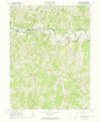
1958 Map of Blacksville
USGS Topo · Published 1973About this map
Dunkard Creek winds through the hills of the West Virginia and Pennsylvania border, defining the settlement patterns of Blacksville and Pentress. In the late 1950s, the landscape was defined by an extensive network of Gas Wells and numerous pipelines cutting across the ridges between Dunkard Creek and Indian Creek. For those tracing local family roots, the map provides a remarkable density of family-named burial grounds including Tennant Cem, Strosnider Cem, and Chisler Cem. Notable community landmarks of the era include a Covered Bridge on Brock Run and a Drive-in Theater near Macdale. The topography is punctuated by distinctive peaks like Minnie Knob and Catherines Knob, while small crossroads such as Daybrook and Jakes Run anchor the rural valleys.
Find a feature on this map
79 named features on this map. Tap any name to fly to it.
Don’t see what you’re looking for? This feature index may not catch every label — zoom into the map to look around manually.
Map Details
Editions of this 1958 Blacksville Map
4 editions found

Other maps of this area

1901 · Waynesburg
USGS Topo · 1:62,500

1904 · Blacksville
USGS Topo · 1:62,500

1904 · Waynesburg
USGS Topo · 1:62,500

1905 · Mannington
USGS Topo · 1:62,500

1905 · Rogersville
USGS Topo · 1:62,500

1923 · Blacksville
USGS Topo · 1:62,500

1923 · Mannington
USGS Topo · 1:62,500

1925 · Blacksville
USGS Topo · 1:62,500

1926 · Mannington
USGS Topo · 1:62,500

1949 · Clarksburg
USGS Topo · 1:250,000