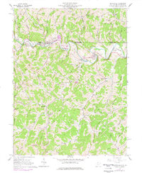
1958 Map of Blacksville
USGS Topo · Published 1977About this map
Blacksville and its surrounding Monongalia County hamlets sit along the winding course of Dunkard Creek, a landscape defined by sharp ridges and deep runs during the late 1950s. The region's economy and lifestyle are visible through specific landmarks like the Drive-in Theater near Macdale and a Covered Bridge crossing Rudolph Run. This topography is heavily marked by the extraction industry, with dozens of Gas Wells peppered across the hillsides of Clay and Battelle districts, alongside a Strip Mine near Days Run. For those tracing local families, numerous small burial grounds such as Tennant Memorial Cem, Strosnider Cem, and Wade Cem are meticulously documented. Educational and social hubs of the era are represented by the High School in Blacksville and the Jakes Run Sch further south.
Find a feature on this map
79 named features on this map. Tap any name to fly to it.
Don’t see what you’re looking for? This feature index may not catch every label — zoom into the map to look around manually.
Map Details
Editions of this 1958 Blacksville Map
4 editions found

Other maps of this area

1901 · Waynesburg
USGS Topo · 1:62,500

1904 · Blacksville
USGS Topo · 1:62,500

1904 · Waynesburg
USGS Topo · 1:62,500

1905 · Mannington
USGS Topo · 1:62,500

1905 · Rogersville
USGS Topo · 1:62,500

1923 · Blacksville
USGS Topo · 1:62,500

1923 · Mannington
USGS Topo · 1:62,500

1925 · Blacksville
USGS Topo · 1:62,500

1926 · Mannington
USGS Topo · 1:62,500

1949 · Clarksburg
USGS Topo · 1:250,000