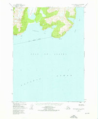
1952 Map of Blying Sound D-5
USGS Topo · Published 1976About this map
Excelsior Glacier dominates the northern coastline of this maritime survey, illustrating the glacial reach toward Johnstone Bay in the early 1950s. The landscape is defined by its dramatic coastal landmarks, including Cape Fairfield and the prominent Mt Fairfield rising above the shore. These features, along with the secluded Puget Bay to the east, suggest a wilderness largely shaped by ice and sea, where land access was restricted by the topography. Compiled from 1950 aerial photographs, the map records the position of Pinnacle Rock and the southern reaches of the Kenai Peninsula Borough as they meet the Gulf of Alaska. The absence of roads or trails on this sheet emphasizes the maritime nature of the region, where navigation relied on points like Cape Junken.
Find a feature on this map
10 named features on this map. Tap any name to fly to it.
Don’t see what you’re looking for? This feature index may not catch every label — zoom into the map to look around manually.
Map Details
Editions of this 1952 Blying Sound D-5 Map
4 editions found
Other maps of this area

1946 · Blying Sound
USGS Topo · 1:250,000

1950 · Seward A-6
USGS Topo · 1:63,360

1950 · Blying Sound D-6
USGS Topo · 1:63,360

1950 · Blying Sound D-4
USGS Topo · 1:63,360

1950 · Blying Sound D-5
USGS Topo · 1:63,360

1951 · Blying Sound
USGS Topo · 1:250,000

1951 · Seward
USGS Topo · 1:250,000

1951 · Seward A-6
USGS Topo · 1:63,360

1951 · Seward A-5
USGS Topo · 1:63,360

1951 · Seward A-4
USGS Topo · 1:63,360