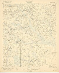
1921 Map of Bowman
USGS Topo · Published 1921About this map
Four Hole Swamp dominates this South Carolina landscape, its sprawling wetlands fed by tributaries like Cow Castle Creek and Goodbys Swamp. The town of Bowman serves as a central hub where the Atlantic Coast Line railroad intersects with significant local thoroughfares, including the historic Five Chop Road. The region is defined by a dense network of early 20th-century rural infrastructure, characterized by an exceptionally high number of neighborhood schools such as Livingston Mill School, Felderville School, and Indian Camp School. These small educational outposts, alongside numerous country churches like Jericho Church and Andrews Chapel, reflect the dispersed agricultural settlement pattern of the coastal plain before mid-century modernization. The presence of Campmeeting Grounds and family landmarks like the Bochette Cemetery provides specific points of interest for genealogists tracing families in the area between Felderville and Whetsell.
Find a feature on this map
81 named features on this map. Tap any name to fly to it.
Don’t see what you’re looking for? This feature index may not catch every label — zoom into the map to look around manually.
Map Details
Editions of this 1921 Bowman Map
4 editions found

Other maps of this area

1919 · Ridgeville
USGS Topo · 1:48,000

1919 · Lodge
USGS Topo · 1:62,500

1920 · Eutawville
USGS Topo · 1:48,000

1920 · Bowman
USGS Topo · 1:48,000

1920 · Lodge
USGS Topo · 1:48,000

1920 · Ridgeville
USGS Topo · 1:62,500

1920 · Orangeburg
USGS Topo · 1:48,000

1920 · St. George
USGS Topo · 1:48,000

1921 · Orangeburg
USGS Topo · 1:62,500

1921 · Lodge
USGS Topo · 1:62,500