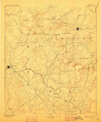
1894 Map of Brownwood
USGS Topo · Published 1918About this map
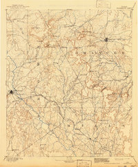
The Gulf Colorado and Santa Fe Railroad cuts a prominent path across the Central Texas landscape, connecting the growing hubs of Brownwood and Comanche during the late nineteenth century. This reconnaissance survey, conducted by Henry Gannett and his team, illustrates a frontier transitioning into a structured cattle and agricultural region. Significant early settlements like Williams Ranch and Blanket are situated among a complex network of watercourses including Pecan Bayou and the Leon River. The terrain is defined by distinct gaps and peaks, such as Mercers Gap and Star Mountain, which historically dictated travel routes before the arrival of the rail. For those researching local lineages, the map identifies small, scattered communities like Zephyr, May, and Hydesport that served as the social centers for early homesteaders in Brown and Comanche counties.
Find a feature on this map
64 named features on this map. Tap any name to fly to it.
Don’t see what you’re looking for? This feature index may not catch every label — zoom into the map to look around manually.
Map Details
Editions of this 1894 Brownwood Map
6 editions found

Other maps of this area

1885 · San Saba
USGS Topo · 1:125,000

1887 · Lampasas
USGS Topo · 1:125,000

1887 · Coleman
USGS Topo · 1:125,000

1888 · Hamilton
USGS Topo · 1:125,000

1889 · Brownwood
USGS Topo · 1:125,000

1889 · Coleman
USGS Topo · 1:125,000

1890 · Stephenville
USGS Topo · 1:125,000

1894 · Brady
USGS Topo · 1:125,000

1894 · Hamilton
USGS Topo · 1:125,000

1894 · Lampasas
USGS Topo · 1:125,000