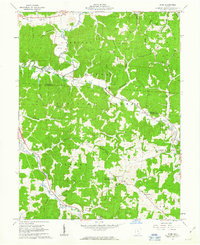
1961 Map of Byer
USGS Topo · Published 1963About this map
Wayne National Forest and the Richland Furnace State Forest dominate this early 1960s landscape, where small southern Ohio settlements are tied together by the winding tracks of the Baltimore and Ohio railroad. The map highlights a rural economy transitioning through the mid-20th century, with numerous strip mines and a Gravel Pit interspersed among family-named ridges like Fairview Ridge and McCune Ridge.
Find a feature on this map
66 named features on this map. Tap any name to fly to it.
Don’t see what you’re looking for? This feature index may not catch every label — zoom into the map to look around manually.
Map Details
Editions of this 1961 Byer Map
4 editions found
Other maps of this area

1906 · Waverly
USGS Topo · 1:62,500

1906 · Chillicothe
USGS Topo · 1:62,500

1908 · Chillicothe
USGS Topo · 1:62,500

1908 · Waverly
USGS Topo · 1:62,500

1910 · Laurelville
USGS Topo · 1:62,500

1912 · Laurelville
USGS Topo · 1:62,500

1913 · Jackson
USGS Topo · 1:62,500

1944 · Jackson
USGS Topo · 1:62,500

1944 · Laurelville
USGS Topo · 1:62,500

1947 · Columbus
USGS Topo · 1:250,000