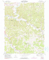
1961 Map of Byer
USGS Topo · Published 1990About this map
The Baltimore and Ohio railroad corridor anchors this survey of southern Ohio, tracing a path through the steep hollows where the border of Vinton and Jackson counties meets. This rugged pocket of the Harrison Wayne National Forest reveals a landscape defined by natural resources and early preservation, featuring the Leo Petroglyph State Memorial near the settlement of Leo. The map documents a period of active land use, with numerous strip mines dotting Fairview Ridge and Richland Ridge, alongside established timberlands in the Richland Furnace State Forest.
Find a feature on this map
64 named features on this map. Tap any name to fly to it.
Don’t see what you’re looking for? This feature index may not catch every label — zoom into the map to look around manually.
Map Details
Editions of this 1961 Byer Map
4 editions found
Other maps of this area

1906 · Waverly
USGS Topo · 1:62,500

1906 · Chillicothe
USGS Topo · 1:62,500

1908 · Chillicothe
USGS Topo · 1:62,500

1908 · Waverly
USGS Topo · 1:62,500

1910 · Laurelville
USGS Topo · 1:62,500

1912 · Laurelville
USGS Topo · 1:62,500

1913 · Jackson
USGS Topo · 1:62,500

1944 · Jackson
USGS Topo · 1:62,500

1944 · Laurelville
USGS Topo · 1:62,500

1947 · Columbus
USGS Topo · 1:250,000